📽️FRIDAY’S FORECAST | The flooding rain and severe weather is gone today, but not for long. I got your weekend weather details on another flooding threat, here. Tune in!
🏈 Your Rutgers tailgate headquarters! Parking at St. George is only 500 yards from SHI Stadium and features 500+ spots, clean restrooms, and quick access to River Road. It’s where Joe parks! Purchase at: www.rutgersparking.com.
WEDNESDAY’S FORECAST | Humid. Muggy. Swampy. Sticky! Call it whatever you want but this will be our most humid stretch of 2026 so far. With the humidity comes the storms but it won’t be a washout.
Jolt your brand with the Shore’s top weather media company. Advertise today! advertise@cupajoe.live
A rare tornado touched down in Cape May Point on Tuesday as part of an unusually active month of severe weather across New Jersey.
The storm began as a waterspout over Delaware Bay before moving onto land. It crossed several streets and faded near Lake Lily, not far from the beach. The tornado remained on the ground for about one minute and produced estimated winds of 70 mph. Trees were damaged along several roads.
It was the first recorded tornado in Cape May Point since reliable records began in 1950. Three other tornadoes were confirmed in Morris County on Tuesday, bringing the statewide total to four for the day. New Jersey typically averages about two tornadoes during an entire year, though the number can vary widely.
Heavy rain also flooded parts of Cape May County. Wildwood received 2.52 inches of rain. PJ Hondros, vice president of ShorelySafe and a Wildwoods resident, called it the area’s worst rain flooding in a long time.
Tuesday’s tornado was the first confirmed in Cape May County since an EF1 struck Woodbine in 2021. Only nine tornadoes have been recorded in the county since 1950. The strongest were F2 tornadoes in 1956 and 1971. Since 1950, the county’s tornadoes have caused only one injury and no deaths.
Sea Isle City, Avalon, Stone Harbor and the Wildwoods have not recorded a tornado during that period, according to the Office of the New Jersey State Climatologist.
The Cape May Point tornado was only one part of a stormy July. Through July 24, the Storm Prediction Center placed at least part of New Jersey under a severe-weather risk on 12 days. That is half of the month so far.
Three days reached an enhanced risk, which is Level 3 on a five-level scale. Those included July 4, when damaging winds and intense rain struck the state; July 18, when several tornado warnings were issued; and July 21, when four tornadoes touched down.
The National Weather Service issued a combined 18 severe-thunderstorm or tornado watches and warnings in New Jersey from July 1 through July 24. The average for that period is about 14.
Extreme heat is one reason for the active weather. Strong thunderstorms often develop as heat waves begin to break. Temperatures across the state have been at least 2 degrees above average this July. Atlantic City International Airport is on pace for one of its three hottest Julys on record.
An unusual weather pattern several miles above the ground has also added more spin to the atmosphere. This type of pattern is more common during spring or fall. When it combines with intense summer heat and humidity, the risk of severe thunderstorms and tornadoes can rise.
There has been one benefit from the repeated storms: Drought conditions have improved. New Jersey remains under a state drought warning, but the share of the state experiencing drought fell by 12 percentage points between the beginning of July and July 23.
Extreme (level 3/4) drought returned to NJ in Cape May and southern Cumberland counties, according to June 11th’s update from the United States Drought Monitor. It’s now the worst statewide drought since March 2025. However, with it being summer, and water usage at its peak for the year, mandatory water restrictions are closer than ever.
Nancy Adler Nutrition has practiced nutrition weight loss, naturally, for 30 years . Listen every Saturday to Nancy Adler Nutrition Live Saturday 11AM-1PM on WOND radio. Ready to lose the weight? Call Nancy at 609-653-4900.
THURSDAY’S FORECAST | Temperatures are 20 to 30F cooler today than they were yesterday. Such is like near Memorial Day Weekend. Much needed rain comes for MDW, that’s the silver lining. I do NOT believe it’s a full washout, though. It even gets warm! Let’s talk.
Why settle for big chains? Choose Just4Wheels’ family-owned locations all across NJ! Rent brand-new sedans, passenger vans, box trucks and more today! Visit www.just4wheels.com or call 877-650-3500.
A “severe” drought (level 2/4) drought now engulfs 50% of New Jersey, including most of the Jersey Shore, according to the United States Drought Monitor on May 14. That’s 30% increase from last week.
The NJ Department of Environmental Protection put the state in a drought warning in November. However, if widespread, soaking rain does not come in the next month, mandatory water restrictions would be possible. That comment comes from State Climatologist Dr. Dave Robinson from our Monthly Weather Roundup show on May 5.
Drought continues for the sixth month in a row in New Jersey, according to the state’s Department of Environmental Protection. Now, though, other indicators are showing warning signs of a crippling drought, too.
Believe it or not, April was in the top 10 for warmest Aprils since records started in 1895. That’s true even though April 21 brought a killing freeze to most of New Jersey only seen once or twice a decade.
Recap the month of weather that was. It’s all Jersey, with two of Jersey’s best weather guys. New Jersey State Climatologist Dr. Dave Robinson as well as Meteorologist Joe Martucci, owner of Cup A Joe Weather and Drone, take you through it all.
"Doesn’t really get more humid than this" | August 2026 MWU
When I talk about this in my weather videos, or post about it on social media, some variation of the same question comes up.
“How could the Jersey Shore be in drought? We had so much snow last winter.”
While yes, we did have well-above-average snowfall (26.1 inches at Atlantic City International Airport, 18.6 inches in Margate, and 39.2 inches in Long Branch), but lots of snow doesn’t necessarily cure a drought. The correlation is pretty weak.
Drought is defined as “a period of abnormally dry weather sufficiently long enough to cause a serious hydrological imbalance,” according to the American Meteorological Society. In other words, if the water going into the environment is less than the water being taken out of the environment (by humans, animals, evaporation, etc.) for a long period of time, you go into drought.
Water comes into the environment by precipitation. Snow is precipitation, so is rain. However, on average in New Jersey, it takes 11 inches of snow to get 1 inch of precipitation. Meanwhile, 1 inch of rain equals 1 inch of precipitation.
Snow to liquid ratio climatology. On average for New Jersey, it takes 10 to 11 inches of snow to produce one inch of precipitation. (via the National Weather Service)
Here’s a look at how much snow, precipitation and average precipitation fell at Atlantic City International Airport from December to February:
In December, there were 2.2 inches of snow, 3.03 inches of precipitation, vs. 3.76 inches of average precipitation.
January saw 6.7 inches of snow, 3.78 inches of precipitation, vs. 3.44 inches of average precipitation.
February recorded 17.2 inches of snow, 3.53 inches of precipitation, vs. 3.12 inches of average precipitation.
Snowfall was about 75% above average during this time. Precipitation was about 5% below average.
What about the snowpack?
This winter probably felt extra long because the snow was on the ground for so long. Twenty-nine days had at least 1 inch of snow covering the ground at Atlantic City International Airport, according to the National Oceanic and Atmospheric Administration, the sixth longest since records began in 1945.
default
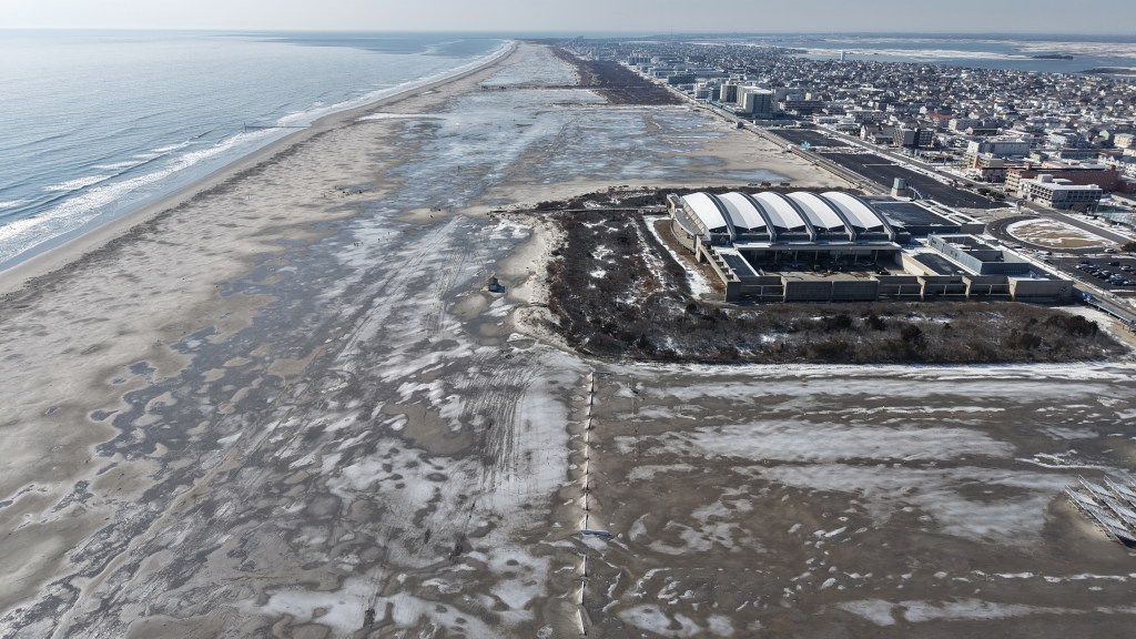
Snow on the ground helps prevent drought from worsening. It allows for snow to slowly melt and seep into the ground. It also prevents the sun from pulling water from the ground and evaporating into the atmosphere.
However, the snowpack wasn’t deep enough nor did it hang around long enough to have a significant impact on the drought.
All things considered, it was a lack of precipitation in March that slid the Jersey Shore into a deeper drought.
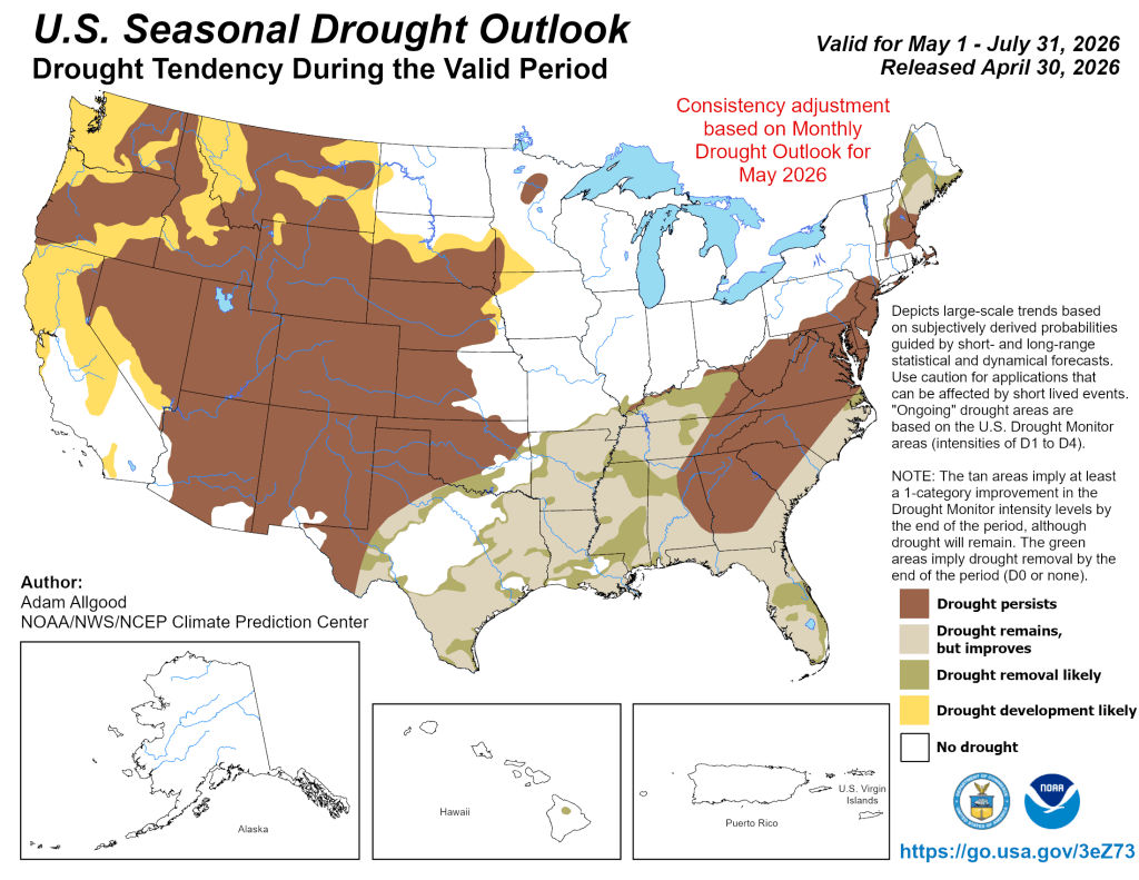
Drought outlook for NJ
NOAA is forecasting that drought conditions will persist through the end of July, according to its April 30 update.
Precipitation across the Jersey Shore, not just in a town or two, needs to average at least 5 inches during this time in order to drown out the drought. More than 4 inches of evaporation occurs during June and July.
We’ll need a few coastal storms, or a very gloomy next month or two, in order to do that. If not, don’t be surprised to see mandatory water restrictions by the end of the summer.
After 3 straight months with colder than average temperatures, March winds up not just warm, but in the top 20 warmest going back to 1895! One thing that didn’t change was precipitation. The Jersey Shore wound up much drier than average and NJ State Climatologist Dr. Dave Robinson is concerned about wildfire season.
Recap the month of weather that was. It’s all Jersey, with two of Jersey’s best weather guys. New Jersey State Climatologist Dr. Dave Robinson as well as Meteorologist Joe Martucci, owner of Cup A Joe Weather and Drone take you through the temperatures, rain, snow, coastal flooding and much more every episode.
New episodes come out the beginning of every month.
FRIDAY’S FORECAST | We go from the 60s this morning to the 40s this afternoon! A nationwide cold front will sag through the Jersey Shore, which is bringing the rain. This weekend has plenty of strong March sun but it’ll be chilly. Let’s talk!