
Tag: el nino

  • EARLIEST forecast polar vortex disruption meets El Niño: NJ forecast

    EARLIEST forecast polar vortex disruption meets El Niño: NJ forecast

    New Jersey’s weather from Thanksgiving to near Christmas could have a wildcard this year, and it starts miles above the North Pole.

    In the video, I explain the likely earliest disruption of the polar vortex. This sudden stratospheric warming event would shape our weather during the holidays. But before you picture snow covering the Parkway, there are a few pieces to understand.

    The stratospheric polar vortex is a ring of strong winds surrounding bitterly cold Arctic air, roughly 10 to 30 miles above Earth. It sits well above the jet stream that helps steer our daily weather. The two can influence each other, but they are separate features.
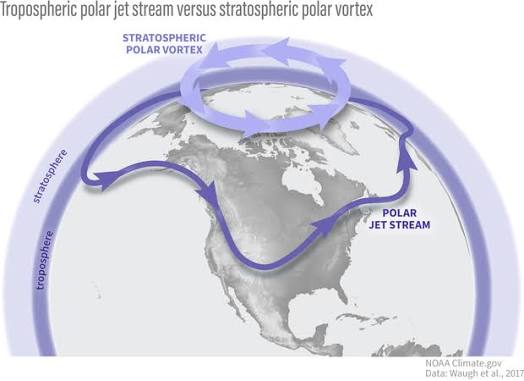
    Image via NOAA

    Sometimes, waves of energy from the atmosphere below disturb that ring. The winds weaken as the polar stratosphere warms quickly. During a major sudden stratospheric warming (SSW), those winds reverse direction. Changes in the weather closer to the ground can follow over the next several weeks, though the results vary.

    This is forecast to happen between Halloween and Nov. 10. It doesn’t matter when. This would be the earliest SSW on record, and it’s not particularly close.
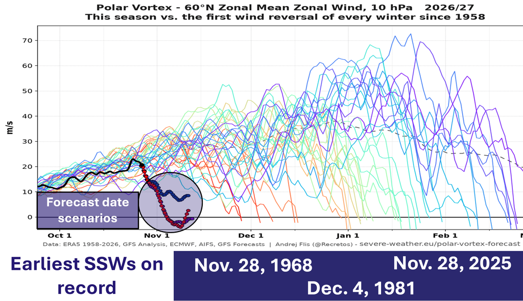
    Via severe-weather.eu

    For New Jersey, that raises questions about cold air and future storm tracks. It does not give us a snowstorm date. A disruption high above the Arctic does not automatically send its effects straight to our state.

    Meanwhile, El Niño is part of the picture. NOAA’s October 8 update confirmed a strengthening El Niño and favored strong to very strong conditions lasting into early 2027. That is a seasonal influence, not a promise about any single storm.

    For snow lovers from Sussex County to Cape May, the key is whether moisture arrives while the air is cold enough. Temperatures through the atmosphere matter: a warm layer can melt falling snow before it reaches your driveway.

    Along the Jersey Shore, keep tidal flooding in the conversation. Persistent onshore winds, waves and high tides can flood coastal communities even without snow. A dry backyard does not always mean a dry road near the bay.

    I’m watching whether the disruption develops, whether its influence reaches the lower atmosphere, and where cold air settles.

    WeatherFront is your one-stop shop for weather data. Experience the game-changing user interface on iOS, Android, or web today at www.weatherfront.com

    Know More: Watch the coupling, then the storm track

    The key diagnostic for a major sudden stratospheric warming is the daily mean zonal wind at 60°N and 10 hPa reversing from westerly to easterly. NOAA’s SSW compendium applies that criterion during November through March. A stretched or split vortex on a map, by itself, does not establish a major warming.

    Next comes downward coupling. Does the stratospheric disturbance influence circulation in the troposphere? NOAA notes that a disrupted vortex can be followed by a wavier jet stream, but the surface response varies. The stratospheric vortex itself does not descend onto New Jersey.

    For NJ forecasting, my next checks are Atlantic blocking, the Pacific pattern, cold-air placement and individual storm tracks. Even with a favorable large-scale setup, precipitation type still depends on the temperature profile. Shore impacts also require a separate look at onshore wind duration and tide timing.

    Treat Thanksgiving into December as a window to monitor, rather than a verified period of major storms.
  • Days of tidal flooding likely in NJ next week, again.

    Days of tidal flooding likely in NJ next week, again.

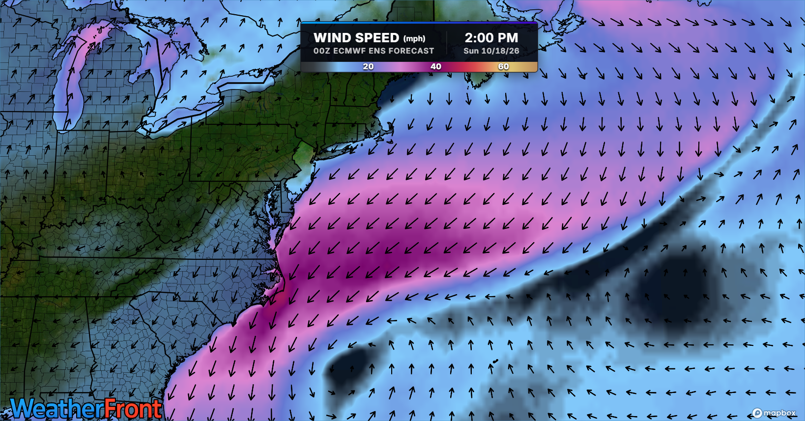
    This *will not* be as high as the nor’easter but it could last as long for NJ.

    Sponsor: ShorelySafe

    📅 As early as next Monday, lasting as long as next Saturday.

    ⚠️You can beat the tidal floods. If you’re a ShorelySafe town, use our Flood Mapper for your town to know when to move your cars and property. If not, have a plan for when water rises, don’t drive through it.

    📏 Right now this looks like minor to borderline moderate flood stage.

    🙏 The moon is helping us out big time. The quarter moon will bring naturally lower tides.

    🤦Expect more of these set ups in our El Nino winter. A low pressure system (storm) stays to our north. High pressure in Ontario and Quebec prevents it from moving north or escaping east. The result? Lots of onshore winds.

  • “Very strong” El Nino most likely this Fall & Winter. What does it mean for NJ?

    “Very strong” El Nino most likely this Fall & Winter. What does it mean for NJ?

    This is a look at our El Niño forecast from Columbia University. You’re looking at all the different computer model runs here, with those lines that kind of peak around September–October–November and then go down as we head toward February–March–April.

    Notice that more than half of them are showing that this is going to be a very strong El Niño, which is a 2°C or greater sea surface temperature anomaly in certain parts of the equatorial Pacific Ocean.

    But let’s look at the record — that’s 3.0°C — and there are even some model runs forecasting that as well. Either way, a very strong El Niño is certainly within the realm of possibility, and it’s virtually guaranteed that this will at least be a strong El Niño.

    What Is El Niño?

    El Niño is when you have warmer-than-average water temperatures across the equatorial Pacific Ocean, from roughly the coast of Peru in South America over to south of the Hawaiian Islands. You see a lot of those reds there in that circle.

    How Does That Impact Our Weather?

    In the next couple of months, it actually means fewer hurricanes. If you look at our hurricane forecasts from the National Hurricane Center or Colorado State University, you see fewer hurricanes due to stronger vertical wind shear (changes in wind direction and height) and greater trade winds. The stronger those east-to-west trade winds are, they can churn up the ocean and bring cooler water up to the surface — meaning again, fewer hurricanes.

    Now, what does this mean for our winter?

    We take a look at our Jersey Shore temperatures during the winter based on El Niño strength. Here’s one thing you notice: when you get to the strong and especially very strong categories, our temperatures get milder. There is a clear trend that as you move toward a stronger/very strong El Niño, you have a mild winter — particularly in the very strong case.

    What About Snowfall?

    We look at the snowfall anomaly (snow compared to average) at Atlantic City International Airport, which averages 17.4 inches. There’s a clear trend for a moderate El Niño to have a much snowier winter. But look at the very strong category — it’s kind of around the average.

    This is where we have to dive in a little bit further. Even though a very strong El Niño shows about average snowfall, it’s really varied. The graphic here shows the average snowfall in that white shaded box for ACY Airport and in Long Branch (pretty much the Jersey Shore). We saw back in 2015–16 above-average snowfall, but 1972–73 as well as 1997–98 saw next to nothing.

    So while generally I do believe that a very strong El Niño trends toward a less snowy than average winter, there are exceptions to this — and in some cases, pretty significant snowy exceptions like we saw in 2015–16.

    Short-Term Outlook

    In the short term, there’s not much to worry about. We’re going to have a less active than usual hurricane season — that’s good news. It doesn’t really have too much of an impact on our summer temperatures or precipitation.

    However, as we go into the winter, we’re going to have to pay close attention to what strength of El Niño we end up with.Quick Recap:

    A very strong El Niño means a much milder than average winter, but has mixed results as to how snowy our winter could be here in New Jersey.

    A strong El Niño means a slightly milder than average winter and well below average snowfall.

    • A strong El Niño means a slightly milder than average winter and well below average snowfall.
    • A very strong El Niño means a much milder than average winter, but has mixed results as to how snowy our winter could be here in New Jersey.