Tag: nor’easter

  • Analysis: Near record high-tides flooded the Jersey Shore Saturday morning

    Analysis: Near record high-tides flooded the Jersey Shore Saturday morning

    Key Points

    • Tuckerton hit second-highest tide in its available record.
    • Thirteen Shore gauges ranked fifth-highest or higher.
    • Atlantic City’s tide ranked 12th since 1911.

    Major stage tidal flooding gripped the entire Jersey Shore Saturday morning, bringing flooding people haven’t experienced in years.

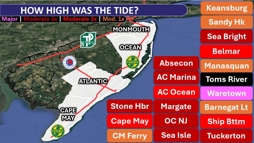
    Water levels rose high enough to rank among the five highest tides in the available record at 13 gauges according to an analysis by PJ Hondros, our Vice President of ShorelySafe,

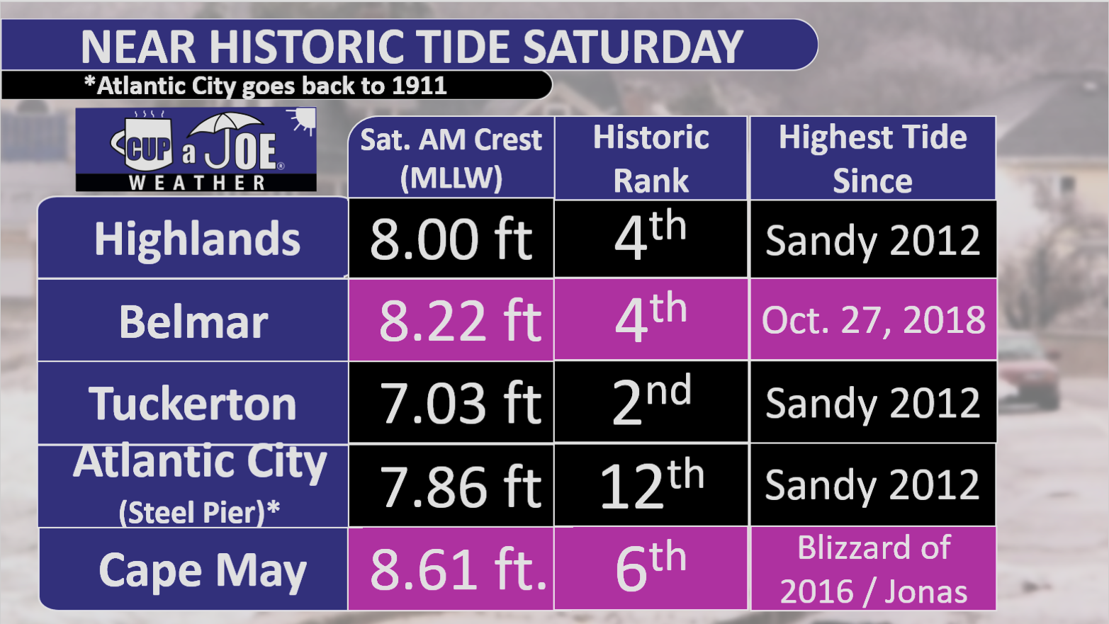
    Tuckerton was one of the biggest standouts. The tide reached 7.03 feet above Mean Lower Low Water, making it the second-highest level in its available record. Ship Bottom also recorded its second-highest tide. Farther north, Highlands reached 8.00 feet and Belmar climbed to 8.22 feet, both ranking fourth in their respective records.

    The flooding was also significant farther south. Cape May reached 8.61 feet, its sixth-highest tide on record. Thankfully, only 1 water rescue was needed in the city.

    Meanwhile, Atlantic City reached 7.86 feet at the long-running NOAA gauge near Steel Pier. That ranked 12th in a record that goes back to 1911.

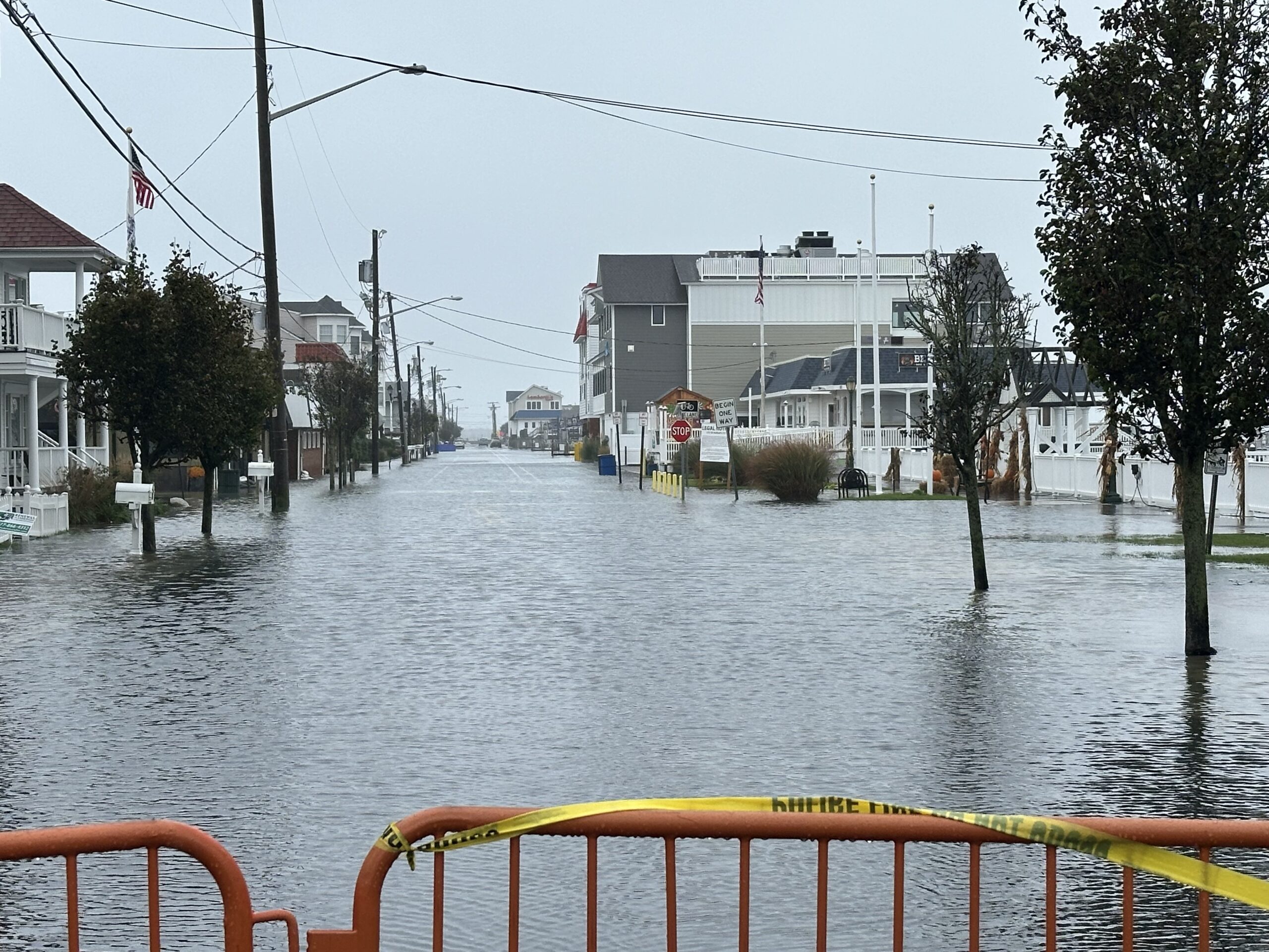
    The numbers help put into perspective what residents saw Saturday morning: water covering low-lying roads, difficult travel in bayside communities and flooding that spread well beyond the spots that take on water during more common high tides.
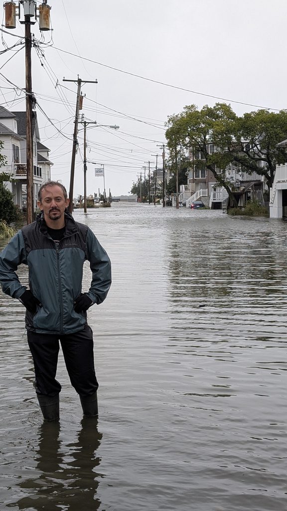
    Take Highlands for example. Nearly every street bayward of Bay Avenue was underwater. That’s as much as four blocks inland. Even cross streets out to Shore Road, another block further inland, had water in spots.

    In my (Joe Martucci’s) 9 years of covering Jersey Shore weather, this was the first tidal flooding I’ve seen with my own two eyes. The only one that rivals it was standing on Melrose Avenue in Atlantic City during the February 2021 nor’easter with two feet of water. One woman in Highlands carried her baby to higher ground. When she got out of the water, you saw it went to her upper thigh. She was about five and a half feet tall.
    Every town floods differently depending on elevation, drainage, bulkheads and local geography. Still, taken together, the gauge data show that Saturday morning was one of the more significant and widespread tidal flooding events to affect the Jersey Shore in recent decades.

    Last High Tide as Significant as 9/26/2026 (oldest to newest)

    Sea Isle City – October 25, 1980

    Margate – December 11, 1992

    Stone Harbor – March 3, 1994

    Cape May Harbor – Superstorm Sandy (2012)

    Atlantic City (Inside Thorofare) – Superstorm Sandy

    Barnegat Light – Superstorm Sandy

    Atlantic City (Steel Pier) – Jan. 23, 2016 (Jonas)

    Tuckerton – Jonas

    Atlantic City (Absecon Channel) – Jonas

    Ocean City – Jonas

    Absecon – Oct. 27, 2018

    Manasquan – Oct. 27, 2018

    Keansburg – Dec. 23, 2022

    Sandy Hook – Jan. 13, 2024

    Cape May – Hurricane Erin (Aug. 2025)

    South Dennis – Hurricane Erin

    Waretown – 2025 Columbus Day Nor’easter

    Sea Bright, Ship Bottom and Avalon did not have a flood on record within 0.25 feet of 9/26’s morning high tide.

    Highest High Tide Since (Oldest to Newest)

    Superstorm Sandy (Oct. 29, 2012) – Atlantic City (Inside Thorofare and Steel Pier), Margate, Sea Bright, Ship Bottom, Tuckerton,

    Blizzard of 2016 / Jonas (Jan. 23, 2016) – Absecon, Atlantic City (Absecon Channel), Avalon, Cape May, Ocean City, Sea Isle City, Stone Harbor.

    Oct. 27, 2018 – Belmar, Manasquan

    Dec. 23, 2022 – Keansburg, Sandy Hook

    Hurricane Erin (Aug. 2025) – South Dennis

    2025 Columbus Day Nor’easter – Waretown

    Know More

    This was a five-day water-loading event, not a one-tide surprise. Since Tuesday, a strengthening coastal low offshore and strong high pressure over eastern Canada have kept a persistent northeast-to-north wind along the Jersey Shore.

    By Wednesday, coastal northeast winds were reaching 30 to 35 mph. That repeated onshore push forced Atlantic water through the inlets and into the back bays.

    Just as important, the bays could not fully drain between high tides, so each new tide started with more water already in the system. The National Weather Service specifically noted water piling up in tidal tributaries and back bays.
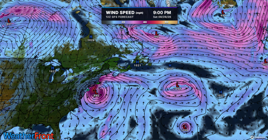
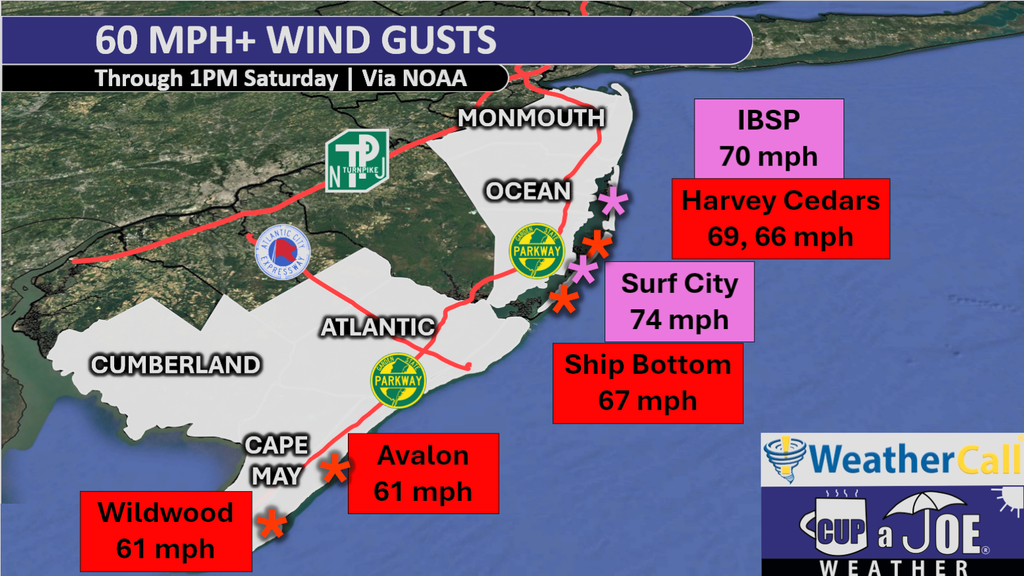
    Then the setup intensified heading into Saturday. The nor’easter deepened and moved closer to New Jersey, tightening the pressure gradient. Winds gusts Friday night went over 60 mph in a number of locations from Ocean County on south. Winds were from the onshore direction.
    Seas built to 15 to 20 feet come Saturday morning. At the same time, Saturday’s full moon was raising the astronomical tide.

    Put it all together you had: days of accumulated water, strong north/northeast winds, low pressure, very rough seas and a higher astronomical tide all peaked at roughly the same time.

    Rain and runoff added to the problem in some back bays, but the main story was storm surge plus the astronomical tide.

    This was similar to Superstorm Sandy in 2012. The storm’s landfall came at high tide on a full moon. In this case, the storm didn’t make landfall, but the high tide was just after a period of the strongest onshore winds on the same day as a full moon.

    Why was this the highest tide since Sandy at some gauges, but since Winter Storm Jonas (2016) at others? Geography.

    Sandy make landfall near Brigantine, just north of Atlantic City. As a result, the most extreme surge was from Atlantic City northward to Raritan Bay, setting an enormous benchmark for central and northern New Jersey.

    Jonas was especially potent farther south: Cape May reached 9.0 feet MLLW in 2016, slightly higher than Sandy’s 8.9 feet there.

    In other words, this storm behaved more like Jonas in 2016 — a prolonged water-piling nor’easter — while each gauge’s historical comparison depends on its local geography and which past storm hit that location hardest.

  • GFS vs. Euro: Where we stand on weekend nor’easter weather forecast in NJ

    A coastal storm will linger near New Jersey into the weekend, but exactly how close it gets will determine the impacts at the Jersey Shore.

    The American GFS model keeps the storm farther offshore. That scenario would mean breezy and mainly dry weather for much of the Shore, although significant tidal flooding, beach erosion, high surf and dangerous rip currents would remain concerns.

    The European model brings the storm closer to New Jersey. That could produce major-stage tidal flooding Friday evening, especially from Long Beach Island south, followed by periods of rain Saturday night into Sunday. Rain could be heavy at times, particularly north of the Atlantic City Expressway.

    The exact track remains uncertain, so keep checking the forecast before making weekend plans.

  • Mostly dry weekend now. LONG stretch of tidal flooding, wind, showers to come

    Mostly dry weekend now. LONG stretch of tidal flooding, wind, showers to come

    🥳SATURDAY’S FORECAST | Some parts of the Jersey Shore will be totally dry until Sunday night! Yes, I said it. Either way, enjoy what we got today, it’ll be the nicest day up and down the coast until at least…. next Sunday?

    Come visit Headley Family Farm at 120 Province Road in West Creek! It’s where farming the pines meets the Jersey Shore. Get your Jersey Fresh produce here. Open weekends and some weekdays. Call us at 609-848-3763 or follow us on Facebook, too!

  • NJ Nor’easter brings top 10 highest tide, record rain, erosion

    NJ Nor’easter brings top 10 highest tide, record rain, erosion

    This article initially appeared in Shore Local magazine on Oct. 16

    It ripped, roared and, most consequentially, flooded. The first nor’easter of the 2025-2026 cool-weather season may very well turn out to be the most powerful one. Here are the most impressive storm stats to me for the Jersey Shore and beyond.

    – The Sunday or Monday afternoon high tide was in the top 10 highest on record for nearly everywhere, from Cape May up to southern Monmouth County, according to the National Oceanic and Atmospheric Administration.

    – Most of Cape May and Atlantic counties saw three consecutive tides in moderate flood stage.

    – Sen. Frank S. Farley State Marina broke a daily rainfall record that had stood since 1927.

    Plus, while we will remember this as a nor’easter, there were tropical characteristics to this storm, too. Let’s explain the details for all of this.

    How severe were the tides at the Jersey Shore?

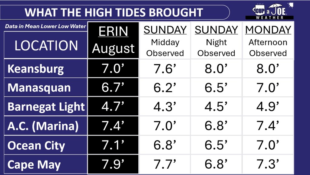
    Atlantic City Marina had its fifth highest tide on record, peaking at 7.4 feet above mean lower low water, the average height of the two lowest low tides Monday afternoon.

    Ocean City had its sixth highest tide on record, reaching 7.0 feet above mean lower low water Monday.

    Down near Exit 0 in Cape May, the ninth highest tide on record, peaking at 7.7 feet above mean lower low water, was experienced on Sunday.

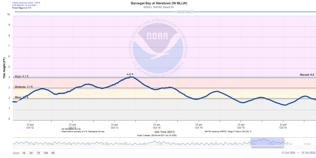
    Ocean County ended up having the highest tides. Barnegat Light in the northern part of Long Beach Island, had the fourth highest tide on record. Meanwhile, across the Barnegat Bay in Waretown, 3 feet of water was recorded in the lowest-lying areas — their worst recorded tide.

    Tide heights in Waretown, Ocean County, on the Barnegat Bay from Oct. 12 to Oct. 15. The 4.21 foot above mean lower low water is the highest in its recorded history (data via the National Oceanic and Atmospheric Administration).

    Farther north Manasquan, Monmouth County, had its 10th highest tide. The least severe flooding was on the Raritan Bayshore. They stayed in minor flood stage.

    There is a caveat to all of this. These records only go back to 2000 at the earliest. So it doesn’t count the 1991 or 1992 nor’easters, the 1962 Ash Wednesday storm or the 1944 hurricane, among others. However, there have been roughly 9,100 days between 2000 and fall 2025. This tide ranks in the top 0.1%. That’s impressive.

    To put things in perspective, it helps to have a recent event with which to compare the storm, so let’s consider Hurricane Erin.

    In late August, Erin brought the highest storm surge on record to the following locations: Absecon, Atlantic City (Inside Thorofare), Sea Isle City, Avalon, Stone Harbor and Cape May (bayside), according to NOAA.

    For the South Jersey shore, south of Long Beach Island, the highest tide stayed near Erin’s height, whether it happened on Sunday or Monday afternoon. North of LBI, at least one of the two tides from the nor’easter were higher than Erin.

    The South Jersey shore could have been worse. Thankfully, winds on Monday morning were from the northwest — offshore — which pushed some of the water out. Had they been northeast, like the rest of the Jersey Shore was, towns like Ocean City and Somers Point would have had tides higher than Erin on Monday afternoon, pushing into major flood territory.

    How much beach erosion occurred at the Jersey Shore?

    The exact details won’t be known until towns and the Army Corps of Engineers complete their post-storm surveys. However, expect to hear that issues are widespread and severe for a few.

    Towns already have stark cliffs of sand on the beach from Erin in August. Tack on additional erosion from a storm in September, and our sand infrastructure was already worse than it would be this time of the year going into the Oct. 12-13 storm.

    I imagine every beach town has more erosion than they’d like to stomach for it being so early in the erosion season. Hopefully, this winter and next spring will have fewer nor’easters than usual.

    Gusts over 60 mph

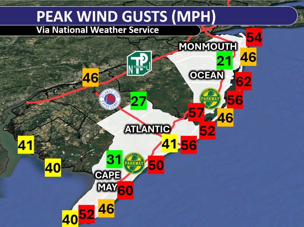
    Wind gusts over 45 mph were widespread east of the Garden State Parkway, and on the bayshores. Island Beach State Park in Ocean County had the highest reported wind gusts, with 62 mph recorded at an Office of the New Jersey State Climatologist weather station. However, Avalon in Cape May County and Surf City in Ocean County also touched 60 mph.

    Here are some other top gusts:

    Atlantic City – 56 mph

    Brigantine – 52 mph

    Cape May Harbor – 52 mph

    Ocean City – 50 mph

    The sustained winds, or constantly blowing ones, made for whistling trees and rattling outdoor furniture Sunday and Monday. Generally, it was 20 to 30 mph at the shore.

    Gusts were much weaker inland. Woodbine in Cape May County reached 31 mph, and Hammonton in Atlantic County only got up to 27 mph.

    Rain was heavy, too

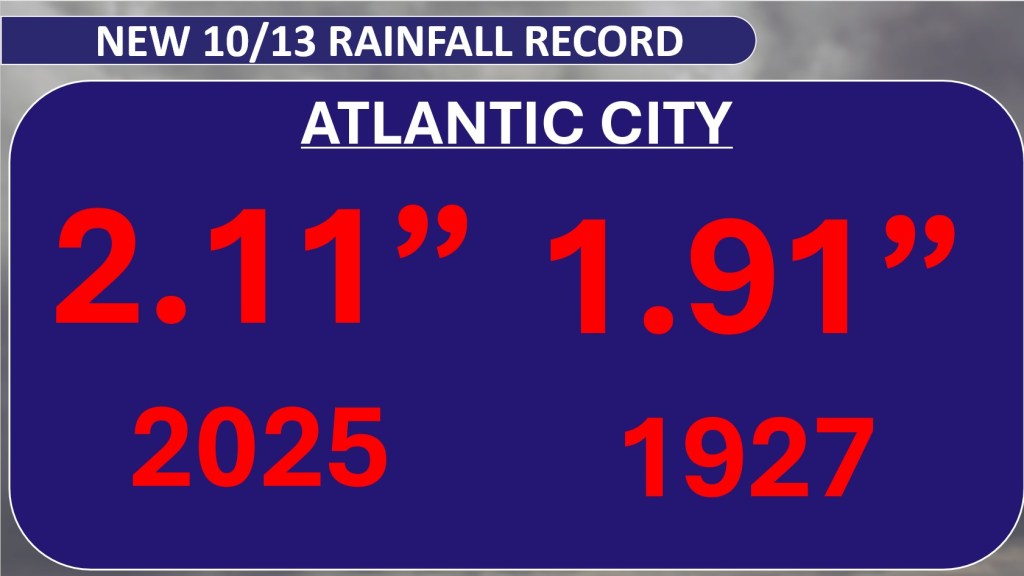
    Rain was the least of our concerns with this storm, but we still had a soaking; that is, east of the Garden State Parkway. Atlantic City Marina broke an Oct. 13 daily rainfall record with 2.11 inches of rain, beating the previous record set back in 1927, according to the NOAA.

    Generally, rainfall totals were between 2 and 3 inches in Atlantic County. Cape May County generally had 1 to 2 inches of rain.

    Once you got away from the four coastal counties — Cape May, Atlantic, Ocean and Monmouth — rainfall measured only up to an inch. Out near Trenton and Philadelphia, it was less than a half inch.

    Jersey Shore streaming weather channel

    I am targeting a launch date between Oct. 18 to 21 for the Jersey Shore’s streaming weather channel. Thanks to Sparkable (who also run the Shore Local website), everything Jersey Shore weather, with a little drone, will be on my YouTube channel and website for your viewing pleasure.

    Tide and marine forecasts, current conditions, forecast videos, radar and support from our sponsors will all be on there. I also want to see your Jersey Shore photos! Submit your sunrises, snow, thunderstorms and fall foliage to be featured in a special shot on the livestream.

    Keep it on your smart TV or computer all day long. Stay tuned for more details.