⚠️MONDAY EVENING UPDATE | The tornado watch is over. Thankfully, no tornadoes at the Jersey Shore (I really didn’t think they’d hit here anyway).
However, we’re not done with the nasty weather yet. Power outages and wind damage are still a concern.
Never worry about missing severe weather warnings again. Get a call from me, text, or email when your location is impacted. WeatherCall ensures you stay informed for just $15 a year. Sign up: https://ngorder.wxriskalerts.com/db_app2.php?station=cajx
MONDAY PM UPDATE | The tornado watch is in effect for the Jersey Shore through 7PM. A wind advisory is in effect until 2AM Tuesday. I still believe the highest severe weather threat is well away from the beaches. Either way, it’ll be worth watching this weather very closely.
Never worry about missing severe weather warnings again. Get a call from me, text, or email when your location is impacted. WeatherCall ensures you stay informed for just $15 a year. Sign up: https://ngorder.wxriskalerts.com/db_app2.php?station=cajx
SUNDAY’S FORECAST | This is a special update on Monday. A wind alert is out for 50+ mph gusts that can knock out power and be a nuisance. That’s before any line of strong storms rumble through that can bring a tornado.
Be safe, be prepared, especially west of the Parkway. Here’s what you need to know.
Never worry about missing severe weather warnings again. Get a call from me, text, or email when your location is impacted. WeatherCall ensures you stay informed for just $15 a year. Sign up: https://ngorder.wxriskalerts.com/db_app2.php?station=cajx
Never worry about missing severe weather warnings again. Get a call from me, text, or email when your location is impacted. WeatherCall ensures you stay informed for just $15 a year. Sign up: https://ngorder.wxriskalerts.com/db_app2.php?station=cajx
From summer heat to winter snow, Mother Nature dropped the Jersey Shore down TWO seasons on the thermometer between 3/11 to 3/13. Let’s recap it all here.
Nancy Alder Nutrition has practiced nutrition weight loss, naturally, for 30 years . Listen every Saturday to Nancy Adler Nutrition Live Saturday 11AM-1PM on WOND radio. Ready to lose the weight? Call Nancy at 609-653-4900.
Yes, it was a cold and snowy winter at the Jersey Shore, for real. Every month had at least one snowstorm, the biggest one being the Feb. 22-23 nor’easter, which the National Weather Service officially classified as a blizzard on March 6.
Climatological winter ended on Feb. 28, but winter cold isn’t done yet as a parting shot of cold air is likely during the middle of March.
Let’s look back at a winter to remember, because we may not get something like this for a long time. (Most of the information here is taken from my Monthly Weather Roundup show with New Jersey State Climatologist Dave Robinson).
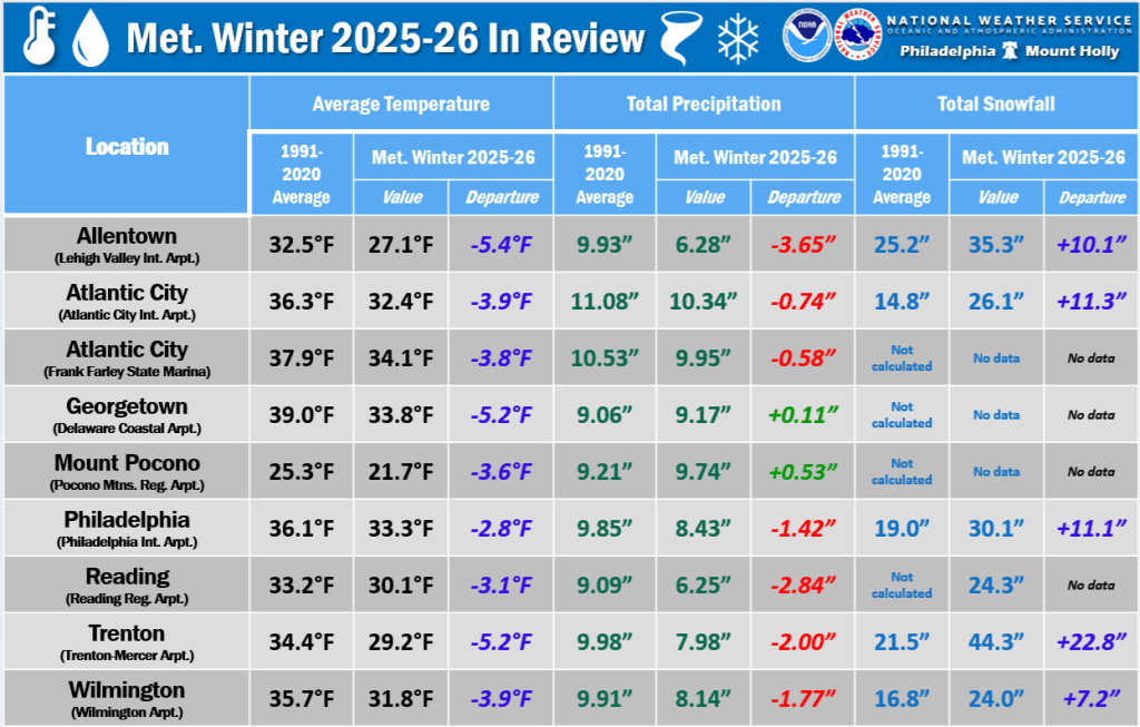
It was a persistently cold and snowy winter for the Jersey Shore. December, January and February were all colder than average, with snow events each month. Temperatures were in the coldest third going back to 1895. However, it was not a top-10 or record-breaking winter because winters have warmed over time.
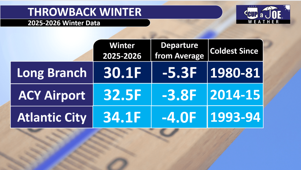
Atlantic City International Airport had its coldest winter since 2014-2015. Go to the beaches and the cold was more impressive. The Sen. Frank S. Farley State Marina in Atlantic City had its chilliest winter since 1993-’94, staying 4 degrees below the 1991-2020 average.
Up the coast, Long Branch lived through its coldest winter since 1980-’81.
Each county in our region reported above-average snowfall. Typically, the Jersey Shore was 10 to 20 inches above seasonal snowfall. There was, however, a noteworthy jump in totals once you went to the northern part of the Jersey Shore, as follows:
Cape May: Woodbine (25.0 inches)
Atlantic: Hamilton (29.4 inches)
Ocean: Manchester (42.4 inches)
Monmouth: Red Bank (49.6 inches)
For snow lovers, it was a great winter.
The drought continues
Despite the heavy snow, it stayed dry overall. Precipitation (including melted snow) was below normal every month. Drought warnings continued from the New Jersey Department of Environmental Protection, with low groundwater levels persisting.
We need more rain or snow soon to avoid worse drought problems this summer.
February nor’easter
The biggest story from February was the nor’easter that hit Feb. 22-23. This storm dropped heavy snow up and down the Shore. Almost everywhere saw double-digit snowfall totals of 10 inches or more.
The storm hugged the coast so eastern New Jersey got the heaviest snow. It stayed mostly snow without switching to rain or ice in many places, which made it feel more like a classic New Jersey winter storm.
It turns out that it was officially a blizzard. It met the criteria of 35 mph or greater winds, and visibility under a quarter of a mile from falling or blowing snow lasting three hours or more.
Interestingly, the slushy cold ocean may have brought higher shore snow totals. Mid-latitude cyclones like this nor’easter intensify along boundaries of cold and mild air. With the cold ocean, the storm had to go out farther east in search of the warmer Gulf Stream.
Sunday snow record
Atlantic City International Airport tied a record for the most snow on a Sunday with 19.6 inches, matching a previous record.
Is it luck? Maybe. Is it a shame? Maybe. That’s up to you to decide.
Lots of snow, but not a record
The Jan. 25 nor’easter and the weather to follow was a unique set of circumstances that led to snow staying on the ground for weeks, literally.
Atlantic City International Airport had the fourth longest stretch with at least an inch of snow on the ground, according to the National Weather Service. Snow stayed on the ground from Jan. 25 to Feb. 14. Up the coast, in Long Branch, the streak was for 27 days.
However, neither of these were records. ACY’s longest stretch was February – March, 2003, with 26 straight days of snow cover. The record in Long Branch is more than twice as long as what we just experienced – 58 days of snow cover made the city look like a glacier from Dec. 23, 1947, to Feb. 18, 1948.
Going a step further, when you look at the greatest number of days with snow cover in a climatological winter (December to February), Atlantic City International Airport ranked fourth, and Long Branch ranked seventh. Thanks to Ray Martin at the National Weather Service in Mount Holly for that.
A winter to remember
Overall, the winter of 2025-2026 reminded people of older, snowier New Jersey winters, but it wasn’t the most extreme ever. It was just reliably cold and white – a fun one for snow fans, but we still need more water to end the dry spell.
Ice and snow covered the beach in Wildwood nine days after the January nor’easter. Photo taken on Feb. 4, 2026 by Joe Martucci.
Joe Martucci, a Certified Broadcast Meteorologist and Digital Meteorologist, is the President and Director of Meteorology for Cup A Joe Weather and Drone. You can connect with him at cupajoe.live/.
📹THURSDAY’S FORECAST: Weather whiplash! Warm this morning, SNOW this evening?! Yeah, it’s possible. There will definitely be a cold rain starting around 12PM though.
Why settle for big chains? Choose Just4Wheels’ family-owned locations all across NJ! Rent brand-new sedans, passenger vans, box trucks and more today! Visit www.just4wheels.com or call 877-650-3500.
WEDNESDAY’S FORECAST: We could break more heat records today! However, what goes up must go down and it will, big time. Temperatures Thursday afternoon will be in the 30s. In between? A big ol’ cold front this will bring our possible severe weather of the season.
If your personal forecast feels uncertain this winter, support is available. See You Through It Counseling offers in-person and virtual therapy for children, adults, and couples. Invest in healing that lasts. Visit seeyouthroughitcounseling.com or call 856-335-1352.
📹TUESDAY’S FORECAST: March is still coming in like a lion. We got 70s today, the possibility of strong thunderstorms tomorrow and then a return to winter later this week! Tune in.
If your personal forecast feels uncertain this winter, support is available. See You Through It Counseling offers in-person and virtual therapy for children, adults, and couples. Invest in healing that lasts. Visit seeyouthroughitcounseling.com or call 856-335-1352.
📹SATURDAY’S FORECAST | Happy Spring Forward weekend! We’ll spring forward on the clocks and the temperatures this weekend. Plus, we have breaking weather news, too! Tune in…