
Joe Martucci, Cup A Joe Weather and Drone President, was happy to join Jersey’s biggest news source to talk about the upcoming winter storm. See the interview below.
Tag: meteorology
-

Winter Storm WARNING now in effect for NJ Sunday (1/25). It’s a wintry mess.
FRIDAY NIGHT UPDATE | There’s a change in the forecast. The snow/sleet is the same but it’s looking more likely that freezing rain is going to create ice rinks on untreated roads and sidewalks Sunday… Don’t forget the bitter cold too. I have it all here.
Also, I’ll be on LiveNOW by Fox at 915PM Friday to discuss the winter storm. You can stream it live on YouTube or your Smart TV.
Our 24×7 Jersey Shore Weather Channel: https://youtube.com/live/_TUjvdihY4s?feature=share
Jolt your brand, advertise here: now-and -
Winter Storm Jonas, 10 years later
I was going to write this column anyway, but with the 2016 Challenge spreading throughout the internet, this came at a perfect time.
The Blizzard of 2016 happened Jan. 22 to 24 of that year. The Weather Channel named it Winter Storm Jonas, which is how many of us know it today.
It came with high winds, rounds of significant coastal flooding, extreme cold and, of course, snow. This nor’easter had it all, enough to make this the fifth most impactful northeast winter storm since records began in 1956, according to the National Oceanic and Atmospheric Administration (NOAA). For context, that’s between the slightly weaker Presidents Day II Blizzard of 2003 and the much stronger Blizzard of 1996.
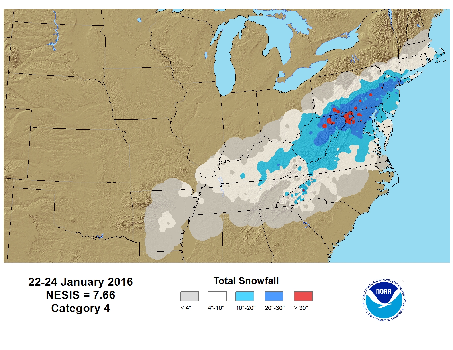
Regional wide snowfall totals from the Blizzard of 2016 (via the National Oceanic and Atmospheric Administration) Sadly, at least eight people died, according to NJ.com, and over 100,000 homes and businesses were without power. Moody’s Analytics estimated $4 billion in damage on the East Coast, in December 2025 dollars.
Jonas is a good reason why my weather dad, Jim Eberwine, always says that we have a 12-month hurricane season here at the shore. Nor’easters around here are feared more for their flooding and wind than the snow itself.
Flooding rivaling Sandy
For those south of Brigantine, where Superstorm Sandy made landfall four years earlier in 2012, the Blizzard of 2016 brought even more significant flooding.
Two rounds of flooding affected the Jersey Shore the mornings of Jan. 23 and 24. The combination of powerful, onshore winds, and the near-full moon drove feet of saltwater into beach towns in some locations.
In Cape May Harbor, the NOAA tide gauge reached a record 9.36 feet above mean lower low water. That was more than a half foot higher than Sandy. Below are others that had a higher crest than Sandy.
Delaware Bay (Cape May):
- 8.98 feet in Jonas
- 8.89 feet in Sandy
- North Wildwood:
- 9.44 feet in Jonas
- 8.9 feet in Sandy
Nearly every tide gauge, from Cape May to Tuckerton, was in major flood stage on Jan. 23. That made travel nearly impossible around the high tide (snow and ice aside) and brought water into homes and businesses that rarely see it.
Farther north through Sandy Hook saw moderate flooding, similar to the flooding we had during the October 2025 nor’easter. Generally the flood level was 3 to 4 feet above normally high ground along the South Jersey shoreline.
There were concerns about saltwater freezing on the roads on the nights of Jan. 23 and 24, as temperatures fell into the 20s. However, that mostly did not occur.
Whipping winds
Power outages were a problem for many at the Jersey Shore. Onshore winds were fierce and drove tidal flooding.
Strathmere had the highest gusts at the South Jersey Shore, topping out at 64 mph at 6:28 a.m. on Jan. 23, according to the National Weather Service. Several places gusted at or over 60 mph, including Ocean City, Cape May and Pleasantville.
However, the strongest winds were in Ocean County. Good Luck Point in Bayville took the top mark statewide at 72 mph. Good luck standing in that. Other Ocean County gusts on Jan. 23 included:
- Tuckerton: 68 mph
- Harvey Cedars: 64 mph
- Beach Haven: 62 mph
- Lakewood: 61 mph
- Seaside Heights: 61 mph
- Holgate: 61 mph
- Beach Haven: 60 mph
Beyond that, many beach towns, from Sea Bright to Cape May, gusted to at least 50 mph once.
A decent amount of snow
The fierce winds blew and snow drifted feet high. However, snow was more of a concern for inland folks rather than people in shore and beach towns.
The highest snowfall totals reported in Atlantic and Cape May counties were 17.5 inches in Buena Vista Township. Closer to the coast, Atlantic City International Airport picked up 12.9 inches. Wildwood Crest had 11.3 inches and Woodbine had 8.6 inches, according to data gathered by the Office of the New Jersey State Climatologist.
In typical Jersey Shore fashion, we had a smorgasbord of precipitation types.
“Snow began falling in the south during the early evening of the 22nd, moving steadily northward,” said Dave Robinson, the New Jersey state climatologist at the time.
“The intensity of the storm grew overnight, with heavy snow falling by the morning of the 23rd, winds howling and ocean waters pouring into coastal communities at times of high tide… Early snow turned over into a mix of snow, sleet and rain in… coastal areas, before turning back to snow toward the storm’s end.”
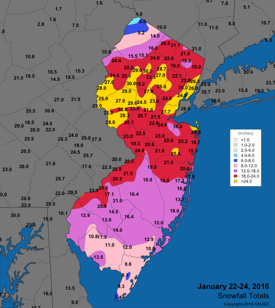
Snowfall totals from the Blizzard of 2016, via the Office of the New Jersey State Climatologist Farther north, it was a high-end snowstorm. Ocean County picked up 12 to 21 inches of snow. Monmouth County’s lower snowfall total was just 16.5 inches in Colts Neck. Rumson picked up 25.5 inches while on the beach, Long Branch saw up to 21 inches. NOAA’s fifth-place ranking aside, the Jersey Shore hasn’t had a winter storm bring quite the combination of snow, wind and tidal flooding since.
For reference, The Blizzard of January 2022 saw 12 to 21 inches up and down the Jersey Shore. Drifts of snow were all around. Thankfully, there was no tidal flooding.
Just a few weeks before that, there was significant flooding and wind in the snowy nor’easter of Jan. 3, 2022 (I was freezing in my rain boots in a foot of water off the White Horse Pike in Atlantic City). Snowfall totals of 9 to 15 inches buried South Jersey in snow. Once you got to Exit 88 on the Garden State Parkway, barely an inch fell.
Is a big snow expected this winter?
I don’t believe so. As mentioned in our winter outlook column, this looks more like the season for medium-sized snows without major tidal flooding, like the one 1/25 to 1/26 for the Jersey Shore. The prevailing storm track doesn’t favor the types of low-pressure systems that form off the Florida or Georgia Coast, and increase in strength as they move north.
That being said, another bitterly cold outbreak is expected late in January through the first half of February. This may be a case of it being too dry to snow much. We’ll keep you updated.
Joe Martucci, a Certified Broadcast Meteorologist and Digital Meteorologist, is the President and Director of Meteorology for Cup A Joe Weather and Drone. You can connect with him at cupajoe.live/.
-
⚠️ MULTI-IMPACT winter storm, bitter cold grip NJ this weekend.
FRIDAY MORNING UPDATE: My snow/sleet forecast remains the same for this Sunday. However, now freezing rain will be added into the mix, not good. Before the winter storm, it’ll be bitterly cold. You’ll need the hat, jacket, scarves and gloves with wind chills around 0F!
Our 24×7 Jersey Shore Weather Channel: https://youtube.com/live/_TUjvdihY4s?feature=share
Jolt your brand, advertise here: joe@cupajoe.live -
Winter storm WATCH for much of NJ: Here are the least, most snowy scenarios.
THURSDAY AM FORECAST: It’s finally time to talk about how much snow will fall across the Jersey Shore. This looks to be a snow to sleet/rain and possibly back to snow for the AC Expressway south. North of there? Mostly snow. Coastal flooding is likely at least once, too.
Our 24×7 Jersey Shore Weather Channel: https://youtube.com/live/_TUjvdihY4s?feature=share
Jolt your brand, advertise here: joe@cupajoe.live
-
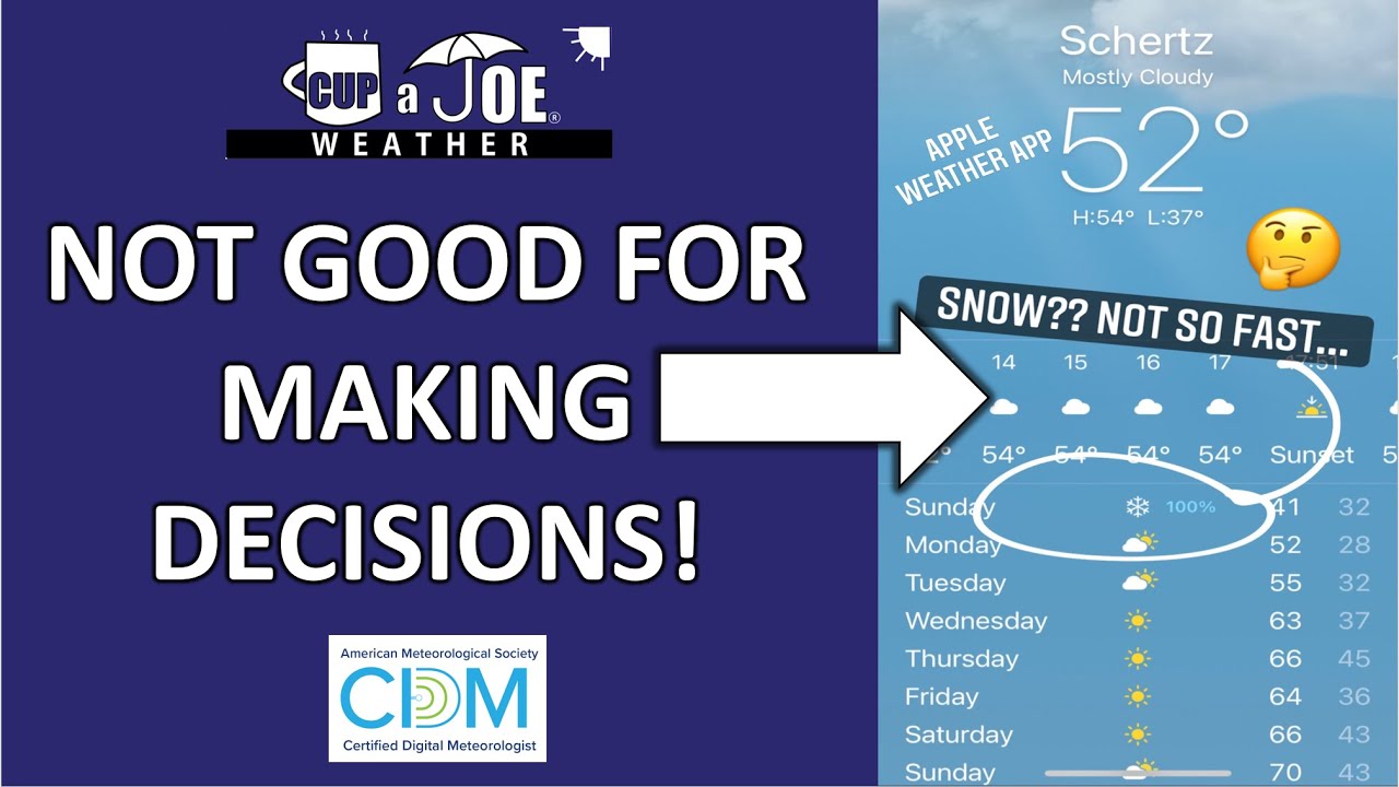
Why generic weather apps are NOT useful for making decisions
Your weather app pre-loaded on Apple, Samsung, etc are made for you to engage with your phone more, not actually give you reliable, trusted weather information. There are no human Meteorologists even involved in that forecast! That’s why they switch so often when the forecast is severe. Only use weather apps that have a real meteorologist(s) behind it!
Local news stations, as well as the Everything Weather apweatyhe are good examples.
Our 24×7 Jersey Shore Weather Channel: https://youtube.com/live/_TUjvdihY4s?feature=share
Jolt your brand, advertise here: joe@cupajoe.live
-
✅ STORM ON: Winter snowstorm likely for NJ Sunday into Monday
WEDNESDAY’S FORECAST: Looking at the data, I’m confident saying a winter storm is ON Sunday into Monday. Plan on cancelling plans. Here’s what I can tell you know.
If your personal forecast feels uncertain this winter, support is available. See You Through It Counseling offers in-person and virtual therapy for children, adults, and couples. Invest in healing that lasts. Visit seeyouthroughitcounseling.com or call 856-335-1352.
-
🥶POLAR PUNCHES: Bitterly cold air hits NJ Tuesday, this weekend
TUESDAY’S FORECAST | Brrrrr. That’s all I can say. Wind chills are in the teens all day long. We’re 20 degrees colder than average. An even longer polar plunge is on the way this weekend and for a long while after. Snow? Too early for that. If your personal forecast feels uncertain this winter, support is available.
See You Through It Counseling offers in-person and virtual therapy for children, adults, and couples. Invest in healing that lasts. Visit seeyouthroughitcounseling.com or call 856-335-1352.
-
How much snow did the Jersey Shore get Sunday 1/18? Compare it to the forecast.
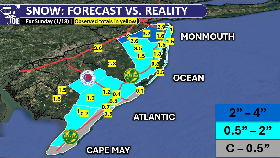
This was a tough system. It took until my very last snowfall forecast early Sunday morning to get it to a good place. It paid off.
The highest snowfall totals were along the New Jersey Turnpike corridor. Generally, two to four inches of snow fell from Salem County, northeast to Bergen County.
Closer to the coast, inland Monmouth County also saw two to four inches of snow. Elsewhere was less. However, everywhere, even Cape May, did get a coating of snow.
View more snowfall reports send into the National Weather Service here.