Tag: snow

  • Canadian Wildfire Smoke Returns: Hazy Skies, Poor Air Quality Ahead for NJ

    Canadian Wildfire Smoke Returns: Hazy Skies, Poor Air Quality Ahead for NJ

    Wildfire smoke from Canada will bring hazy skies and poor air quality to New Jersey this week.

    The first round of smoke is expected Tuesday afternoon and evening. A second, stronger round should arrive Wednesday afternoon and continue into the evening. Some people may even notice a campfire-like smell Wednesday.

    A high-pressure system over the central United States is creating northwest winds. Those winds are carrying smoke from wildfires in Ontario and other parts of Canada toward New Jersey.

    About 800 wildfires were active across Canada as of Tuesday, July 14.

    The smoke will arrive as New Jersey also deals with high heat and humidity Wednesday. The combination could produce milky skies, reduced air quality and the smell of smoke across parts of the state.

  • Waving goodbye to retired NJ State Climatologist Dr. Dave Robinson in June’s Weather Roundup

    Waving goodbye to retired NJ State Climatologist Dr. Dave Robinson in June’s Weather Roundup

    On June 30, 2026 Dave Robinson, the New Jersey State Climatologist since 1991 and Distinguished Professor at Rutgers University, retired.

    Dave Robinson is my birthday buddy (May 13th), research advisor (2013), Monthly Weather Roundup co-host, weather dad and friend.

    He is New Jersey climate. In the science world, knowing your stuff and communicating that stuff doesn’t always go hand in hand. He mastered both. He’d just ask quickly do a Zoom call for an interview as he would spit off a list of the top 10 most humid years in New Jersey’s history.

    “What I find incredibly inspiring about Dave is that he really was the essence of the office for several decades,” John Krasting, the incoming state climatologist said. “I’m going to be inheriting a wonderful program that has developed over the years into one of the leading state climate offices in the nation.”

    From left to right: Joe Martucci, Shawnie Martucci, Dr. Missy Holtzer, Dr. Dave Robinson, Christina Marguccio and Nick Marguccio during Dave’s retirement symposium in April 2026 at Rutgers University.

    My journey with Dr. Robinson began in 2013, during my last semester at Rutgers, when I wanted to do research for credit. The topic was dew point climatology, looking at moisture in the air across different parts of New Jersey.

    That report is still somewhere at the State Climate Office, or maybe at Dave’s home. Either way, it became a valuable learning experience. It also gave me the chance to meet Mat Gerbush, the assistant state climatologist, and a young Dan Zarrow, now Chief Meteorologist for NJ 101.5 and Townsquare New Jersey.

    After I graduated, it would be six years before Dave and I connected again.

    We were both at the New Jersey Emergency Preparedness Association conference in Atlantic City. He was there to give a talk. I was there to cover it as the new meteorologist for The Press of Atlantic City.

    For months, I had wanted to talk with him about New Jersey weather and climate. He had long been such a positive, trusted voice for science in the state. Still, I was nervous. We hadn’t talked in years. Would he remember me?

    I’m pretty sure he did.

    I walked up to him, we made small talk, and he asked about my career. Then I asked if he would be interested in doing a podcast episode with me for The Press. The show was called Something in the Air, and the idea was to look back at the previous month’s weather and place it in the larger context of climate.

    He said yes.

    The issue was figuring out how to do it remotely. He was in Piscataway. I was in Galloway. It was 2019: pre-COVID, pre-work-from-home, pre-remote-everything.

    We ended up using Stockton University’s TV program, where The Press produced its newsmagazine show, -30-. The first couple of episodes were shaky, but they worked. I can’t find video from those early days.

    Then COVID happened.

    No more TV studio. Instead, I used a new program called Zoom to interview him. No virtual backgrounds, no polished setup. Just my apartment and his kitchen.

    It worked, but it a far cry from today.

    There were many early struggles then, mainly my fault. I couldn’t get my external mic to work on Zoom. We’d have weird black spots on the video from the video boxes being the wrong space. I think one time I forgot to hit record. Still, he kept recording with me giving grace (perhaps having the same birthday helped).

    Eventually, the Something in the Air podcast turned into the Monthly Weather Roundup. We did it almost every month for years! Two of them, my other weather dad, Jim Eberwine, filled in.

    The longest break was after Lee Enterprises laid me off in June 2024. I took the summer off to regroup and when I started Cup A Joe Weather and Drone, the Monthly Weather Roundup came back in October 2024.

    The publicity of the episode has only grown since then. We’re back into audio podcasts, we create vertical videos from the episodes and break out parts of the show. Subtitles were added earlier in 2026 to increase your experience. All was good.

    When Dave told me he was retiring, I was happy for him. He loved his work. The days (and nights) were long. He has his kids, wife and most importantly, his grandkids. He loves to travel and now he could go during the semester!

    Even he doesn’t know how he’ll go from 60 hour work weeks to retirement. A Yankees game the day after his retirement and trip to Europe following that will help a bit. The reality will probably settle in later this summer. He’s also moving on from the Rutgers Global Snow Lab, which he ran for years.

    I hope you all enjoyed this iteration of the Monthly Weather Roundup. We documented every month of New Jersey weather for the past 7 years, giving important context that a brief sound bite or quote in an article can’t do.

    “People have some level of knowledge, but they often do not appreciate the full impact weather and climate have on every aspect of society. It affects transportation, the economy, tourism, emergency management, agriculture, the environment and daily life,” Robinson said.

    Now, I hope his daily life is full of snow for cross-country skiing, sunshine for his biking and time with his family.

    The Drought Situation: An Overview

    The month of June has brought alarming news regarding drought conditions across New Jersey. As of the end of June, areas stretching from Long Beach Island down to Cape May County are experiencing extreme drought (D3), while much of the state is under severe (D2) and moderate drought (D1) categories. Farmers, like those from Headley Family Farm in Eagleswood, are feeling the impact as irrigation systems struggle to maintain crops amidst low surface water and minimal precipitation.

    The next drought monitor report, set to be released on July 2nd, will provide an update on these conditions. Interestingly, while the highlands have seen some recovery with recent rains, the coastal areas remain critically dry. This disparity highlights the need for targeted rainfall to alleviate stress on water resources.

    Historical Context: Precipitation Deficits

    June’s precipitation levels reflect a troubling trend, with New Jersey averaging below-normal rainfall for the month. This marks the twenty-third out of the last twenty-six months with below-average precipitation, a situation not seen since the mid-1960s. Dr. Robinson notes that this persistent drought is characterized more by its longevity than by extreme dry spells. In the past two years, New Jersey has seen consistent deficits, with precipitation often falling to about 75% of normal levels.

    The coastal counties have been particularly hard hit, receiving only a fraction of the expected rainfall. For instance, Cape May recorded just over two inches for June, compared to the average of nearly four inches. This ongoing drought not only threatens crops but also raises concerns about water availability for residents and wildlife.

    The Transition of Dr. Dave Robinson

    As we reflect on the month’s weather, it’s also a moment to acknowledge Dr. Dave Robinson, who has been New Jersey’s state climatologist since 1991 (which as long as Joe Martucci’s been alive). As he prepares for retirement, he shares his mixed feelings about leaving a position he has held with pride. Robinson emphasizes the importance of proper timing in transitioning from a career, noting that he looks forward to spending more time with family and pursuing personal interests, including his writing projects.

    Dr. Robinson also highlights the importance of understanding climate patterns and their implications for agriculture and water resources in New Jersey. His insights serve as a reminder of the impact weather and climate have on our daily lives and the necessity for ongoing monitoring and research.

    Looking Ahead: What’s Next for New Jersey Weather?

    With the hot summer months ahead, the potential for heatwaves raises further concerns about drought conditions. New Jersey typically experiences its wettest month in July, but the current forecasts suggest that the areas most in need of rain may continue to face challenges. Robinson urges residents to be proactive in water conservation and to stay informed about local restrictions.

    As we move into July, the call for rain is more urgent than ever. The combination of high temperatures and low humidity could exacerbate the already dry conditions, leading to increased fire risks during holiday celebrations like Independence Day. Residents should be mindful of fire safety and follow local guidelines to protect their communities.

    Conclusion

    June has been a month of mixed emotions and pressing challenges for New Jersey. As we bid farewell to Dr. Robinson, we also prepare for the ongoing struggle against drought. Understanding these weather patterns is crucial for adapting to future climate challenges. For now, we hope for a shift in the weather that brings much-needed rain to our parched state.

    Frequently Asked Questions

    What is the current drought status in New Jersey?
    As of late June, New Jersey is facing severe drought conditions, particularly in coastal areas.

    How does the drought impact local farmers?
    Farmers are struggling with low surface water and are relying heavily on irrigation to sustain their crops.

    Why is Dr. Dave Robinson stepping down?
    Dr. Robinson is retiring to spend more time with family and pursue personal projects.

  • “Very strong” El Nino most likely this Fall & Winter. What does it mean for NJ?

    “Very strong” El Nino most likely this Fall & Winter. What does it mean for NJ?

    This is a look at our El Niño forecast from Columbia University. You’re looking at all the different computer model runs here, with those lines that kind of peak around September–October–November and then go down as we head toward February–March–April.

    Notice that more than half of them are showing that this is going to be a very strong El Niño, which is a 2°C or greater sea surface temperature anomaly in certain parts of the equatorial Pacific Ocean.

    But let’s look at the record — that’s 3.0°C — and there are even some model runs forecasting that as well. Either way, a very strong El Niño is certainly within the realm of possibility, and it’s virtually guaranteed that this will at least be a strong El Niño.

    What Is El Niño?

    El Niño is when you have warmer-than-average water temperatures across the equatorial Pacific Ocean, from roughly the coast of Peru in South America over to south of the Hawaiian Islands. You see a lot of those reds there in that circle.

    How Does That Impact Our Weather?

    In the next couple of months, it actually means fewer hurricanes. If you look at our hurricane forecasts from the National Hurricane Center or Colorado State University, you see fewer hurricanes due to stronger vertical wind shear (changes in wind direction and height) and greater trade winds. The stronger those east-to-west trade winds are, they can churn up the ocean and bring cooler water up to the surface — meaning again, fewer hurricanes.

    Now, what does this mean for our winter?

    We take a look at our Jersey Shore temperatures during the winter based on El Niño strength. Here’s one thing you notice: when you get to the strong and especially very strong categories, our temperatures get milder. There is a clear trend that as you move toward a stronger/very strong El Niño, you have a mild winter — particularly in the very strong case.

    What About Snowfall?

    We look at the snowfall anomaly (snow compared to average) at Atlantic City International Airport, which averages 17.4 inches. There’s a clear trend for a moderate El Niño to have a much snowier winter. But look at the very strong category — it’s kind of around the average.

    This is where we have to dive in a little bit further. Even though a very strong El Niño shows about average snowfall, it’s really varied. The graphic here shows the average snowfall in that white shaded box for ACY Airport and in Long Branch (pretty much the Jersey Shore). We saw back in 2015–16 above-average snowfall, but 1972–73 as well as 1997–98 saw next to nothing.

    So while generally I do believe that a very strong El Niño trends toward a less snowy than average winter, there are exceptions to this — and in some cases, pretty significant snowy exceptions like we saw in 2015–16.

    Short-Term Outlook

    In the short term, there’s not much to worry about. We’re going to have a less active than usual hurricane season — that’s good news. It doesn’t really have too much of an impact on our summer temperatures or precipitation.

    However, as we go into the winter, we’re going to have to pay close attention to what strength of El Niño we end up with.Quick Recap:

    A very strong El Niño means a much milder than average winter, but has mixed results as to how snowy our winter could be here in New Jersey.

    A strong El Niño means a slightly milder than average winter and well below average snowfall.

    • A strong El Niño means a slightly milder than average winter and well below average snowfall.
    • A very strong El Niño means a much milder than average winter, but has mixed results as to how snowy our winter could be here in New Jersey.
  • Why this snowy winter was NOT enough to cure NJ’s 2026 drought

    Why this snowy winter was NOT enough to cure NJ’s 2026 drought

    This article initially appeared in Shore Local News on April 30, 2026

    It’s unanimous, according to the state and federal agencies in charge of keeping track of drought conditions.

    Since November, New Jersey has been in drought, according to the state Department of Environmental Protection. Then, on April 14, the Jersey Shore was put into drought by the United States Drought Monitor, only to cover the entire state a week later.

    When I talk about this in my weather videos, or post about it on social media, some variation of the same question comes up.

    “How could the Jersey Shore be in drought? We had so much snow last winter.”

    While yes, we did have well-above-average snowfall (26.1 inches at Atlantic City International Airport, 18.6 inches in Margate, and 39.2 inches in Long Branch), but lots of snow doesn’t necessarily cure a drought. The correlation is pretty weak.

    Drought is defined as “a period of abnormally dry weather sufficiently long enough to cause a serious hydrological imbalance,” according to the American Meteorological Society. In other words, if the water going into the environment is less than the water being taken out of the environment (by humans, animals, evaporation, etc.) for a long period of time, you go into drought.

    Water comes into the environment by precipitation. Snow is precipitation, so is rain. However, on average in New Jersey, it takes 11 inches of snow to get 1 inch of precipitation. Meanwhile, 1 inch of rain equals 1 inch of precipitation.

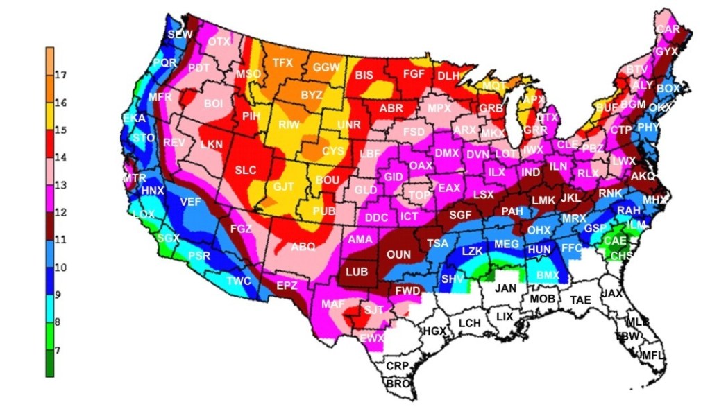
    Snow to liquid ratio climatology. On average for New Jersey, it takes 10 to 11 inches of snow to produce one inch of precipitation. (via the National Weather Service)

    Here’s a look at how much snow, precipitation and average precipitation fell at Atlantic City International Airport from December to February:

    In December, there were 2.2 inches of snow, 3.03 inches of precipitation, vs. 3.76 inches of average precipitation.

    January saw 6.7 inches of snow, 3.78 inches of precipitation, vs. 3.44 inches of average precipitation.

    February recorded 17.2 inches of snow, 3.53 inches of precipitation, vs. 3.12 inches of average precipitation.

    Snowfall was about 75% above average during this time. Precipitation was about 5% below average.

    What about the snowpack?

    This winter probably felt extra long because the snow was on the ground for so long. Twenty-nine days had at least 1 inch of snow covering the ground at Atlantic City International Airport, according to the National Oceanic and Atmospheric Administration, the sixth longest since records began in 1945.

    default

    Snow on the ground helps prevent drought from worsening. It allows for snow to slowly melt and seep into the ground. It also prevents the sun from pulling water from the ground and evaporating into the atmosphere.

    However, the snowpack wasn’t deep enough nor did it hang around long enough to have a significant impact on the drought.

    All things considered, it was a lack of precipitation in March that slid the Jersey Shore into a deeper drought.

    Drought outlook for NJ

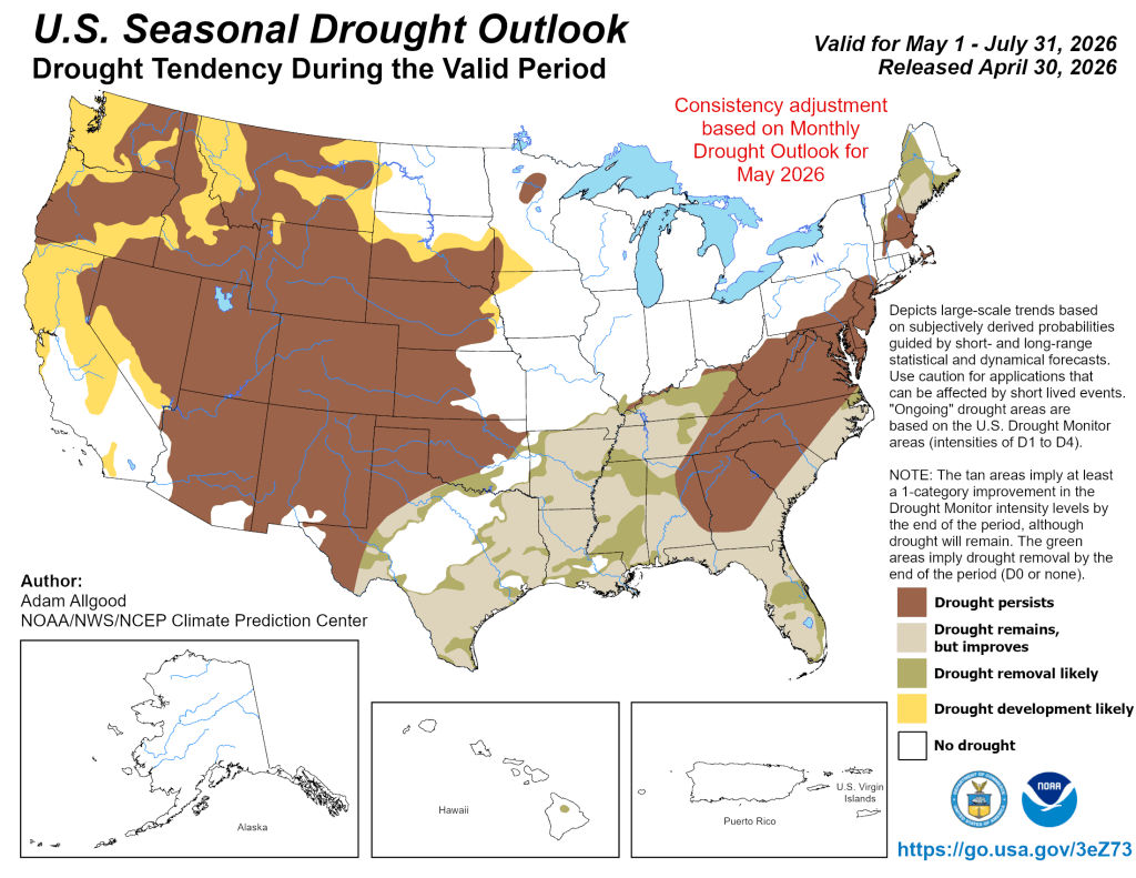
    NOAA is forecasting that drought conditions will persist through the end of July, according to its April 30 update.

    Precipitation across the Jersey Shore, not just in a town or two, needs to average at least 5 inches during this time in order to drown out the drought. More than 4 inches of evaporation occurs during June and July.

    We’ll need a few coastal storms, or a very gloomy next month or two, in order to do that. If not, don’t be surprised to see mandatory water restrictions by the end of the summer.

  • How will developing El Niño impact NJ’s weather in 2026?

    How will developing El Niño impact NJ’s weather in 2026?

    Goodbye La Niña and hello El Niño – possibly a “super” El Niño.

    Expected between July and September, this shift in the Earth’s long-term weather patterns will define how we experience the upcoming hurricane season, as well as the snow and cold of next winter.

    Forecasters from the National Oceanic and Atmospheric Administration give El Niño a greater-than-60% chance of developing during the summer. By the fall, during the peak of hurricane season, it’s an 80% chance.
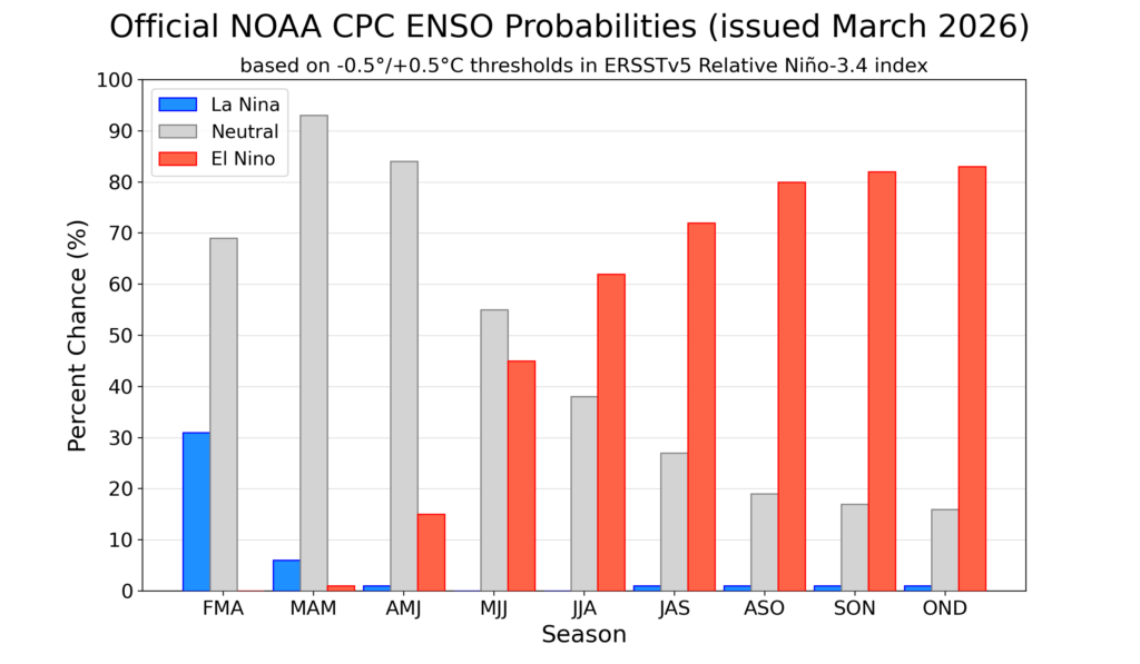
    By July, the chances of an El Nino developing are over 50% (via NOAA)

    El Niño or La Niña is part of the El Niño Southern Oscillation (ENSO). This refers to the water temperatures off the Equatorial Pacific Ocean, from roughly Peru westward 7,000 miles. When water temperatures are warmer than average, it’s El Niño. When it’s cooler than average, it’s La Niña.
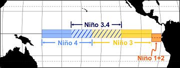
    Via NOAA

    Meteorologists break this down into four different zones within the ENSO region. I won’t explain it much here, but where those warmer temperatures are this summer and beyond will make a slight difference in what our long-term forecast will be.

    Since the summer of 2024, we have been in La Niña. That typically means milder winters. However, both the 2024-2025 winter, and this past winter, were colder than average.

    The frozen tundra of snow and ice we experienced for weeks this past winter bucked the La Niña trend, too. For hurricane season, 2024 was more active than usual, while 2025 was about average. That checks out with a La Niña pattern.

    Let’s look at what El Niño will mean for both the 2026 hurricane season, and the 2026-2027 winter, plus what a “super” El Niño could mean for New Jersey.

    Quieter hurricane season likely
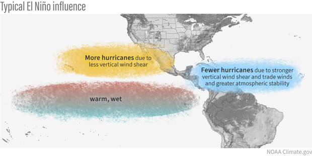
    When El Niño is present, hurricane activity in the Atlantic Hurricane Basin goes down; it’s that simple. The Atlantic Hurricane Basin averages 14 named storms – seven hurricanes including three major hurricanes (Category 3, 4 or 5) per season, per Colorado State University. Since 1990, there have been 11 hurricane seasons with El Niño. Seven were less active, while two were about average and two were more active.

    More than likely, this hurricane season will be as active or less active than average. With a 24% chance of the eye of a tropical storm or hurricane being within 50 miles of the Jersey Shore, that number should be lower as well. Hurricane season officially runs from June 1 to Nov. 30.

    During El Niño, there is stronger windshear in the tropical Atlantic Ocean. Windshear is a change of wind direction or speed as you go up from the surface. This, in short, rips apart developing cyclones.

    Winter temperatures

    The stronger the El Niño, the warmer the temperatures. By itself, El Niño doesn’t mean much for our temperatures during the winter. Since ENSO records began in the 1950s, winters with El Niño end up about average at Atlantic City International Airport and the Sen. Frank S. Farley State Marina in Atlantic City.

    However, when you look at the intensity of the El Niño, the pattern becomes clear.

    Very Strong: 4.0 degrees warmer than average

    Strong: 0.5 degrees warmer than average

    Moderate: 0.7 degrees colder than average

    Weak: 0.5 degrees colder than average.
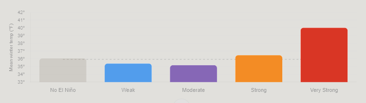
    Mean temperature between December and February for Atlantic City International Airport and Sen. Frank S. Farley State Marina in Atlantic City, based on the intensity of the El Nino (graphic is from Claude Artificial Intelligence, via NOAA data).

    The stronger the El Niño, the warmer the temperatures. That’s because the Pacific jet stream – the river of air about 30,000 feet high that separates two airmasses – pushes into the Northeast. That means more opportunities for us to be south of the jet stream, taking in milder air.

    Winter snow: One clear signal

    Like winter temperatures, using El Niño alone doesn’t produce a big trend in what snow could look like for a winter. Generally, it’s a little less snowy than average. However, when you look at the type of El Niño, there is a trend that screams off the chart.

    When El Niño is in a moderate phase, it’s 13 inches snowier than average. For the South Jersey shore, that’s 25 to 30 inches of snow. Farther up the coast, that’s roughly 30 to 35 inches of snow.

    Here’s the snow breakdown for Atlantic City International Airport and Long Branch, by El Niño phase.

    Weak: 3.5 inches below average

    Moderate: 13.2 inches above average

    Strong: 3.4 inches below average

    Very strong: 0.2 inches above average
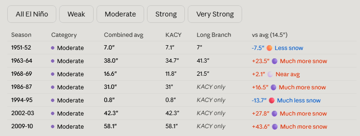
    Winter snowfall totals for the Jersey Shore, based on the intensity of the El Nino (graphic is from Claude Artificial Intelligence, via NOAA data)

    The last two moderate El Niño winters were 2009-’10 and 2002-’03. Both brought plenty of snow, and winter storms. That included:

    The Dec. 19 to 21, 2009 winter storm, which brought double-digit snowfall across the entire Jersey Shore.

    On Feb. 5-7, 2010, over 20 inches of snow fell roughly south of the Atlantic City Expressway. Meanwhile, New York City experienced less than 4 inches of snow.

    A few days later, the Feb. 9-11 winter storm brought over half a foot of snow to the shore.

    The Feb, 16-18, 2003, winter storm, known as the President’s Day II or PDII storm, dropped over 18 inches of snow on much of the Jersey Shore and ranks as the sixth strongest winter storm on NOAA’s Northeast Snowfall Impact Scale.

    Moderate El Niños sit in a weather sweet spot for winter storms in New Jersey. They enhance the jet stream’s pattern in a way that funnels nor’easters up the coast without warming the region enough to flip precipitation to rain.
    What if a ‘super’ El Niño arrives?

    There is no guarantee that a very strong El Niño, or what people call a “super” El Niño, will come this winter. However, given the confidence of El Niño developing late this year, it’s worth exploring. Severe-Weather.Eu has a nice writeup on it.

    If one does form, expect a mild winter with a low number of nor’easters. However, when nor’easters do hit, expect plenty of rain, wind or even snow.

  • Cold and Snowy, for real: Winter 2025-26 at the Jersey Shore

    Cold and Snowy, for real: Winter 2025-26 at the Jersey Shore

    Yes, it was a cold and snowy winter at the Jersey Shore, for real. Every month had at least one snowstorm, the biggest one being the Feb. 22-23 nor’easter, which the National Weather Service officially classified as a blizzard on March 6.

    Climatological winter ended on Feb. 28, but winter cold isn’t done yet as a parting shot of cold air is likely during the middle of March.

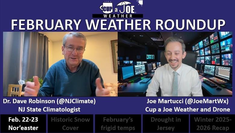
    Let’s look back at a winter to remember, because we may not get something like this for a long time. (Most of the information here is taken from my Monthly Weather Roundup show with New Jersey State Climatologist Dave Robinson).

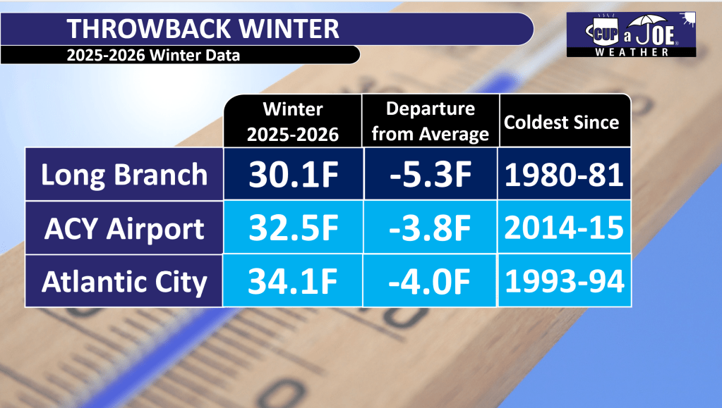
    It was a persistently cold and snowy winter for the Jersey Shore. December, January and February were all colder than average, with snow events each month. Temperatures were in the coldest third going back to 1895. However, it was not a top-10 or record-breaking winter because winters have warmed over time.

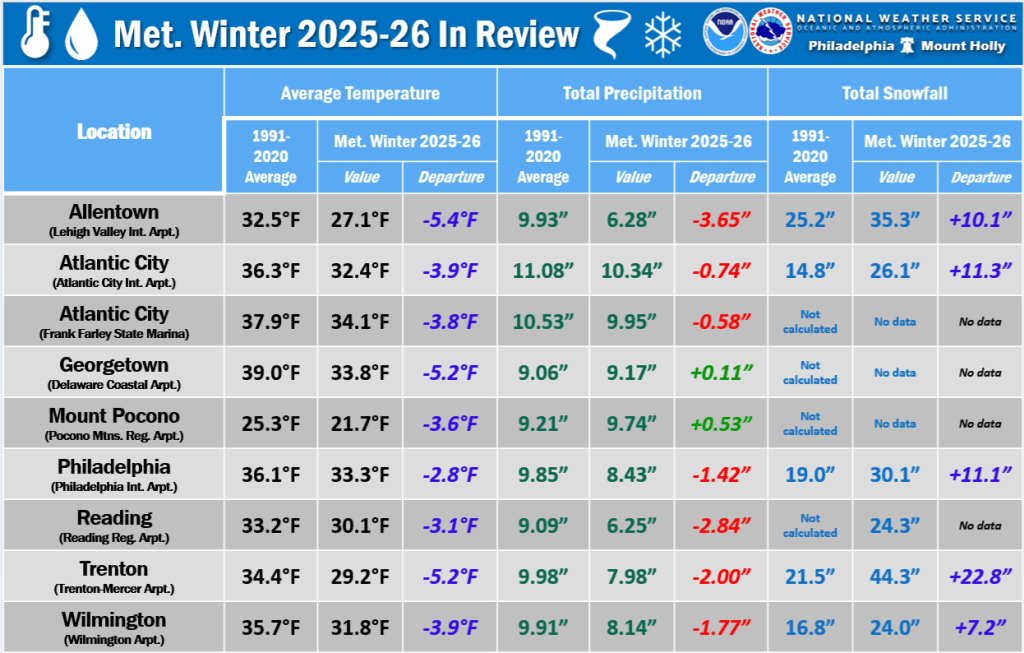
    Atlantic City International Airport had its coldest winter since 2014-2015. Go to the beaches and the cold was more impressive. The Sen. Frank S. Farley State Marina in Atlantic City had its chilliest winter since 1993-’94, staying 4 degrees below the 1991-2020 average.

    Up the coast, Long Branch lived through its coldest winter since 1980-’81.

    Each county in our region reported above-average snowfall. Typically, the Jersey Shore was 10 to 20 inches above seasonal snowfall. There was, however, a noteworthy jump in totals once you went to the northern part of the Jersey Shore, as follows:

    • Cape May: Woodbine (25.0 inches)
    • Atlantic: Hamilton (29.4 inches)
    • Ocean: Manchester (42.4 inches)
    • Monmouth: Red Bank (49.6 inches)

    For snow lovers, it was a great winter.

    The drought continues

    Despite the heavy snow, it stayed dry overall. Precipitation (including melted snow) was below normal every month. Drought warnings continued from the New Jersey Department of Environmental Protection, with low groundwater levels persisting.

    We need more rain or snow soon to avoid worse drought problems this summer.

    February nor’easter

    The biggest story from February was the nor’easter that hit Feb. 22-23. This storm dropped heavy snow up and down the Shore. Almost everywhere saw double-digit snowfall totals of 10 inches or more.

    The storm hugged the coast so eastern New Jersey got the heaviest snow. It stayed mostly snow without switching to rain or ice in many places, which made it feel more like a classic New Jersey winter storm.

    It turns out that it was officially a blizzard. It met the criteria of 35 mph or greater winds, and visibility under a quarter of a mile from falling or blowing snow lasting three hours or more.

    Interestingly, the slushy cold ocean may have brought higher shore snow totals. Mid-latitude cyclones like this nor’easter intensify along boundaries of cold and mild air. With the cold ocean, the storm had to go out farther east in search of the warmer Gulf Stream.

    Sunday snow record

    Atlantic City International Airport tied a record for the most snow on a Sunday with 19.6 inches, matching a previous record.

    Is it luck? Maybe. Is it a shame? Maybe. That’s up to you to decide.

    Lots of snow, but not a record

    The Jan. 25 nor’easter and the weather to follow was a unique set of circumstances that led to snow staying on the ground for weeks, literally.

    Atlantic City International Airport had the fourth longest stretch with at least an inch of snow on the ground, according to the National Weather Service. Snow stayed on the ground from Jan. 25 to Feb. 14. Up the coast, in Long Branch, the streak was for 27 days.

    However, neither of these were records. ACY’s longest stretch was February – March, 2003, with 26 straight days of snow cover. The record in Long Branch is more than twice as long as what we just experienced – 58 days of snow cover made the city look like a glacier from Dec. 23, 1947, to Feb. 18, 1948.

    Going a step further, when you look at the greatest number of days with snow cover in a climatological winter (December to February), Atlantic City International Airport ranked fourth, and Long Branch ranked seventh. Thanks to Ray Martin at the National Weather Service in Mount Holly for that.

    A winter to remember

    Overall, the winter of 2025-2026 reminded people of older, snowier New Jersey winters, but it wasn’t the most extreme ever. It was just reliably cold and white – a fun one for snow fans, but we still need more water to end the dry spell.

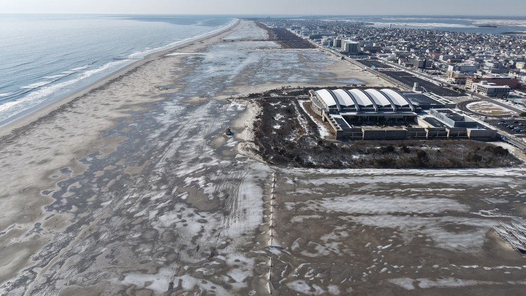
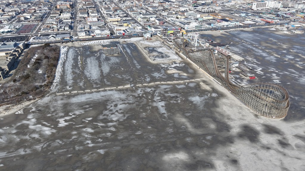
    Ice and snow covered the beach in Wildwood nine days after the January nor’easter. Photo taken on Feb. 4, 2026 by Joe Martucci.

    Joe Martucci, a Certified Broadcast Meteorologist and Digital Meteorologist, is the President and Director of Meteorology for Cup A Joe Weather and Drone. You can connect with him at cupajoe.live/.

  • Thursday’s weather: 60s this morning, snow this evening?! 😵

    Thursday’s weather: 60s this morning, snow this evening?! 😵

    📹THURSDAY’S FORECAST: Weather whiplash! Warm this morning, SNOW this evening?! Yeah, it’s possible. There will definitely be a cold rain starting around 12PM though.

    Why settle for big chains? Choose Just4Wheels’ family-owned locations all across NJ! Rent brand-new sedans, passenger vans, box trucks and more today! Visit www.just4wheels.com or call 877-650-3500.

  • ❌It is not that wet for the rest of the week in NJ, I promise

    ❌It is not that wet for the rest of the week in NJ, I promise

    THURSDAY’S FORECAST | Despite what the generic weather app says, the rest of the week will not be all that wet. The Cape May Bubble will be in effect, with the driest weather. Our spring fever is still on track to start Sunday! See how warm the beaches and inland areas will get here.

    Our 24×7 Jersey Shore Weather Channel: https://www.youtube.com/watch?v=lGssDGu6xk0
    Jolt your brand, advertise here: joe@cupajoe.live

  • ☃️COLD and SNOWY, for real | February 2026 and Winter Monthly Weather Roundup

    ☃️COLD and SNOWY, for real | February 2026 and Winter Monthly Weather Roundup

    Join us as we review the intense winter weather in New Jersey, including record snowfalls, blizzards, and drought conditions, with State Climatologist Dr. Dave Robinson. Discover the details behind the storms, snowpack, and what to expect in the coming months.

    00:00 Introduction to February Weather Roundup
    02:00 The February Nor’easter: Impact and Analysis
    12:05 Snowpack and Its Effects on Weather Patterns
    17:00 Winter Overview: Cold and Snowy Trends
    22:55 Drought Conditions and Future Predictions
    24:30 It was cold this winter, but…


    Recap the month of weather that was. It’s all Jersey, with two of Jersey’s best weather guys. New Jersey State Climatologist Dr. Dave Robinson as well as Meteorologist Joe Martucci, owner of Cup A Joe Weather and Drone take you through the temperatures, rain, snow, coastal flooding and much more every episode. New episodes come out the beginning of every month.

    Cup A Joe Website: www.cupajoe.live
    NJ Climatologist’s Office: www.njclimate.org

  • Off The Radar podcast interviews Joe Martucci on February nor’easter

    Off The Radar podcast interviews Joe Martucci on February nor’easter

    My friend and fellow Certified Digital Meteorologist Emily Gracey puts together a kick butt podcast called Off The Radar. Every week, she does a 20-30 minute show about weather, climate, the environment and how we interact with it.

    It’s not just some random podcast, either. Based in Charleston, SC Off The Radar won the National Headliner Award for “Best Information Podcast” in 2025.

    Emily had me join the show to talk about our February 22-23 nor’easter in New Jersey. If you thought the 12 inch-plus snow was a lot here, Emily’s other guest, Meteorologist Chris Gloninger had over 30 inches of the white stuff in Cape Cod. Another weather friend of ours, Chris broke down the societal impacts of the heavy snow and wind. The storm there was a true emergency in that corner of the country.

    Listen on Apple
    Listen on Spotify
    Listen on Audible
    Listen on YouTube