
FIRST SNOW IS HERE | We’re getting reports of snow flakes flying near Cape May. Now, we’ll track that light snow up the coast as we go into Friday morning. What your generic weather app won’t tell you? Icy roads that are possible early Saturday.
Never worry about missing severe weather warnings again. Get a recorded call from me when your location is impacted. WeatherCall ensures you stay informed for just $15 a year. Sign up: https://ngorder.wxriskalerts.com/db_app2.php?station=cajx
Tag: snow
-

First SNOW of winter underway, for some | Friday, 12/5/2025 Weather Forecast
-

A Supermoon and the 1st Snow | Thursday, 12/4/2025 Weather Forecast
THURSDAY’S FORECAST | Our 1st snow of the season is on pace to fall over parts of the Jersey Shore on Friday. I have one big change in the forecast compared to yesterday you’ll want to tune in for. Also, happy Full Cold Supermoon day!
-

Historic 1st Snows at Jersey Shore: Facts and Figures
The first snow of the season at the Jersey Shore is usually something to smile about. It’s light and fun. Maybe just a few flakes in the air or a quick snow shower that melts fast. It makes you think of cozy things: a warm fire, snow on the sand at the beach, or a surprise day off from school or work.
At two weather stations near the Jersey Shore – Atlantic City International Airport and Lower Township – the first snow average is 1.6 inches deep. That’s not much. Most people think it’s more fun than trouble.
However, sometimes the first snow is a big surprise.
Four times at Atlantic City International, and three times in Lower Township, the very first snowy day of the season dropped more than 6 inches. That’s a lot for the first one.
I love snow any time, but a huge first snow can catch everyone off guard. It’s like playing a big game without warming up, or running a race in brand-new shoes. Nobody is ready yet. Meteorologists might miss a forecasting tidbit. Road crews might not put out enough salt and plows. Drivers forget to go slow and careful like they do later in winter. That makes slippery roads extra dangerous.
On average the first real snow at the Jersey Shore waits until the second half of December. However, there are a few times in weather history when snow has been noteworthy and early.

December 5, 2002
In 2002 the first snow of the season at the Jersey Shore was a nor’easter that dropped more than 6 inches of snow.
Every county in New Jersey had snow, according to NOAA. An area of low pressure developed on a frontal boundary along the Gulf Coast states. Eventually, that low pressure moved through the Southeastern United States, went off the North Carolina coast and quickly raced northeast, according to Raymond C. Martin Jr. It was a nor’easter.
Snowfall totals were sizeable:
- 7.6 inches in Estell Manor, Atlantic County
- 7.0 inches in Hammonton, Atlantic County
- 6.0 inches in Woodbine, Cape May County
- 5.5 inches in Green Creek, Cape May County
- 5.0 inches at Atlantic City International Airport

Perhaps more impressive was that these totals were greater than the snow seen the entire previous winter in much of South Jersey. This was in the middle of a long stretch of colder-than-average temperatures. The snow that fell took six days to fully melt across the area as high temperatures stayed below 35 degrees nearly every day from Dec. 4 to Dec. 10.
November 30, 1967
Before 2002, you had to go back 35 years to experience a first winter storm as significant for the Jersey Shore.
At ACY Airport 7.8 inches of snow fell, the second largest leading snowfall of the season on record (a late start in 2022 was higher). Lower Township experienced 3.0 inches of snow.
This snow engulfed much of the Mid-Atlantic. A Baltimore Sun headline proclaimed: “Near Record November Snowfall Catches City Without Its Plows.”
November 6, 1953
This is one of the largest first snows on record, and one of the earliest, too. Snow spread from western North Carolina to New England.
This wasn’t a 100% snowstorm; 3.2 inches of snow at ACY Airport mixed with a total of 3.98 inches of precipitation. In essence, about 10% of the precipitation that fell was snow. Still, it counts.
Places farther south saw less snow mixed in. By the time you went to Lower Township, the storm was all rain. The Cape May Bubble was still alive and well then, too.
The New York Times wrote that New York’s highways were covered in an icy sheen and many motorists going upstate had to sleep overnight in their cars.
The storm was tropical at first. It was a tropical depression that moved across Florida. It then transitioned from a warm-core, tropical storm, into a cold-core, nor’easter. Ready for the storm was a huge mass of cold air in the Northeastern United States. That turned what was warm rain into some snow.
December 8, 1928
The third biggest first snow of the season in Lower Township’s long stretch of weather records (back to 1897), was a pure snowmaker, even at the immediate coast.
Lower Township saw 9.6 inches of snow on 0.80 inches of precipitation, according to NOAA. That’s a snow ratio of 12:1, meaning this wasn’t a sloppy, wet mess of snow, either.
ACY Airport wasn’t around yet. However, Atlantic City kept snow records then and they were blanketed in 3.9 inches of snow. High temperatures stayed in the 30s for the next two days after that, keeping the snow on the ground, too.
Archive weather maps from NOAA show that this was a coastal storm. Low pressure the morning of Dec. 8 was roughly 40 degrees north latitude, and 75 degrees west longitude. Today, that’s known as the “benchmark,” or the position coastal storms should cross to bring at least some snow to the coast. Winds were from the north or northeast at the Jersey Shore, pumping in the icy air.
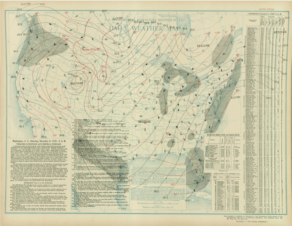
The surface weather analysis for the Dec. 8, 1928 snow. The National Weather Service was a part of the United States Department of Agriculture then. Thanksgiving Day, 1912
Talk about cold turkey. Nov. 28, 1912, brought a statewide blanket of snowfall, delivering a rare “White Thanksgiving.” In fact, it has an argument to claim a spot as the snowiest Thanksgiving on record statewide.
In Lower Township, 4.5 inches fell. In Atlantic City, Northfield and Tuckerton, 4.0 inches fell.
Barely an inch of snow fell in Taylor Ham land in the northern part of the state (yes, there’s a Central Jersey).
I imagine there were a lot of melted (dirt) roads that turned into ice at night. The days following it were well above freezing during the day, dropping a good bit below freezing at night.
Like the early 1928 snow, this storm was a coastal storm. Known as a Miller A type storm, it began off the Georgia coast. It quickly moved north-northeast, passing almost right at that 40-degree north latitude, 75 degree west longitude benchmark.
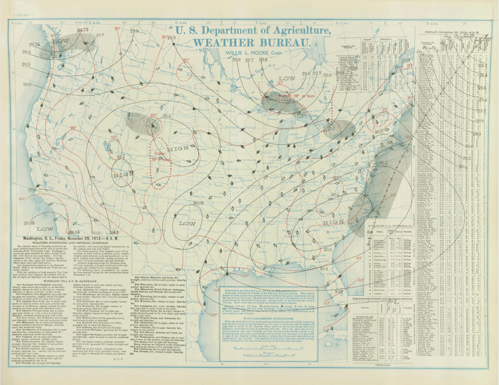
The surface weather analysis for the Thanksgiving 1912 snow. The National Weather Service was a part of the United States Department of Agriculture then. What are your snow thoughts?
Love it? Hate it? You want one snow and then that’s it? Drop me a note on social media or email.
Joe Martucci, a certified broadcast meteorologist and digital meteorologist, is also the president and director of meteorology for Cup A Joe Weather and Drone. You can connect with him at cupajoe.live/.
-
A wild ride of temperatures: 2025-2026 Jersey Shore Winter Outlook
The 2025-2026 winter outlook has similarities to last winter’s weather. However, there’s enough support in the forecast to give snow lovers hope this season. My Jersey Shore friends, it’s that time of the year again – time for the winter forecast.
With the sun setting by 5 p.m., holiday decorations for sale at nearly every store and sweatshirt weather during the day, snow season is around the corner.
Before we get into predictions, here’s a few important notes to remember:
1. I don’t do my own winter forecasting. It takes a lot of time and research that begins in August and ends around Halloween. This forecast is a mix of some research I’ve done and information from trusted sources like Steve DiMartino of NY NJ PA Weather, a fellow certified digital meteorologist.
2. Miles make a difference. In one storm, Ocean City could be all rain, while Egg Harbor Township has 3 inches of snow and Asbury Park has a foot. This forecast is for the general shore area, not one particular house.
3. Average snowfall is meaningless at the shore area. Atlantic City International Airport averages 17.3 inches of snow, according to the National Oceanic and Atmospheric Administration. However, since records began in 1944, four winter seasons had less than an inch of snow, and six were buried in more than 40 inches of snow.
4. The ocean, which keeps our fall warmer than the New Jersey Turnpike corridor during the fall, also keeps us milder during the winter. An onshore wind with a nor’easter will keep the lawns brown, not white. You have to go to northwestern New Jersey, the Poconos and places north to be guaranteed snow.
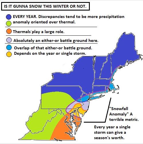
Via @CotentWeatherGuy on X. Still, the winter forecast is exciting. It’s the most popular outlook of the year and I love talking about it with you.
How did last year’s winter forecast do?
Lower Township, at the southern end of Cape May County, had the most snow in the entire Jersey Shore area – 20.5 inches fell there. In fact, the only places in the state that were higher were northwest of Interstate 287, in the typically colder northwest New Jersey.
Otherwise, most of Atlantic, Cumberland and Cape May counties saw between 12 and 18 inches of snow. Farther north, the rest of the shore only had 7 to 12 inches.
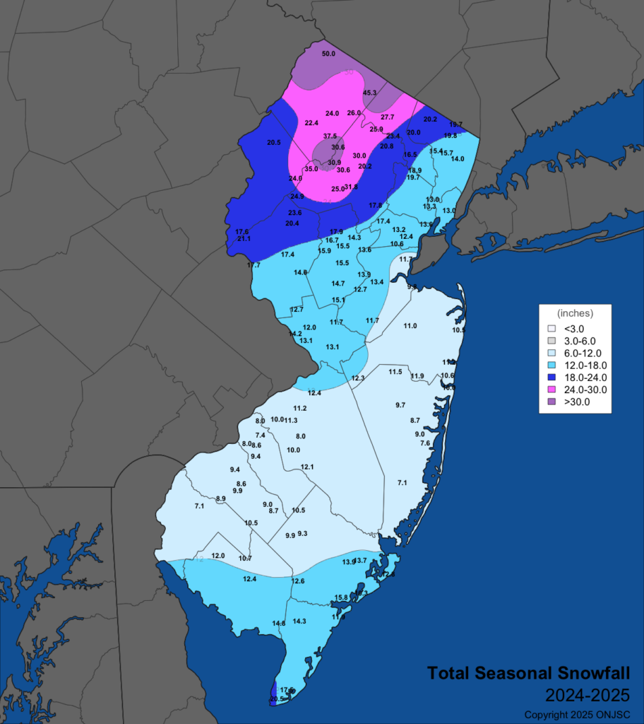
Snowfall totals from the 2024-2025 winter (via The Office of the New Jersey State Climatologist) Last year’s forecast column stated: “It’s safe to say that we can expect fewer storms with a possibility of snow.” I gave the shore a 65% chance of snow being 3 inches below the 14.8-inch seasonal snow average at the immediate coast, and the 17.4-inch average for the mainland. Consider it a pretty good forecast.
The not-so-great forecast was the coastal flooding outlook. I wrote that “near-to-slightly-above-average coastal flooding” was likely. Thank goodness this was wrong. Coastal flooding and beach erosion were nearly nonexistent.
The column also stated that temperatures would be “warmer than usual overall.” Turns out, our 37.9-degree average from December to March was just above the 30-year climate average of 37.6 at Atlantic City International Airport. At the beaches, the average at Sen. Frank S. Farley State Marina in Atlantic City was 38.9 degrees – below the average of 39.7.
Quick Jersey Shore winter forecast
Expect a couple of lighter snow events (less than 4 inches), with a better-than-average chance for bigger storms (4 to 8 inches). However, massive snow of more than a foot is less likely than usual.
Temperatures should be about average when everything is said and done. However, this should be due to big swings in temperatures averaging out to near average throughout the year. Four days of near-60-degree weather, followed by four days of 30-degree weather, is a strong possibility. Our first sustained cold shot looks to be at some point between Thanksgiving and Christmas.
Expect more coastal storms than usual. At the risk of sounding wishywashy, some will be mostly rain, and some will be mostly snow.
Beach erosion and tidal flooding will be more of a quantity than a quality (big issues) thing. However, with the beaches already damaged in spots, it’s a concern.
Jersey Shore winter forecast in more detail
The outcomes for this winter will be largely driven by three factors.
1. Weak La Niña, or colder-than-average water temperatures in the equatorial Pacific Ocean.
2. Much warmer-than-average water temperatures in the Pacific Ocean, off the United States West Coast.
3. Less-than-usual Arctic Ocean sea ice in North America.
You can’t start a winter forecast without looking at the state of the El Niño Southern Oscillation. This explains whether water temperatures in the equatorial Pacific Ocean are warmer or colder than average. We’re in La Niña, so it’s cooler than average.
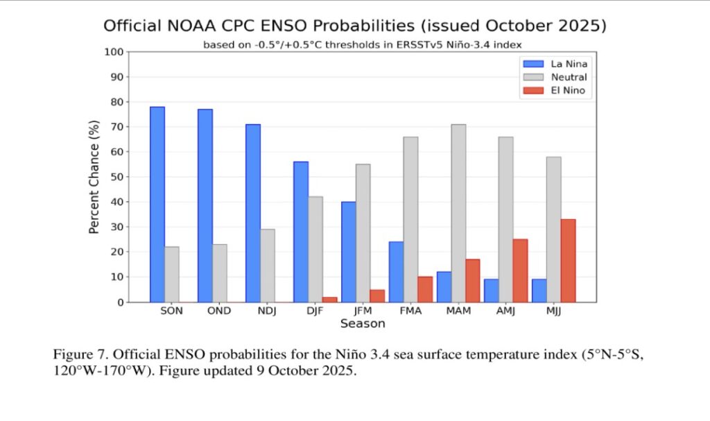
NOAA expects La Nina to continue through at least January (DJF). However, a weak La Niña is only expected to last until February, according to NOAA. We may then go into a neutral state for the rest of the winter. Either way, the point is La Niña favors a slightly cooler and drier winter.
The next two factors both support stormier-than-usual winter patterns. The relatively warm water off the West Coast supports a storm track right through the Mid-Atlantic. Storms during the winter love a clash of cold and mild, and these line up perfectly for our region to be the battleground.
Meanwhile, sea ice is well below average on the North American continent. Unless something crazy happens, it will stay this way. That opens the jet stream – the river of air about 30,000 feet high – which is also the storm track, causing it to look like a rollercoaster, snaking south to north over the Eastern United States.
When the Jersey Shore is on the northern side of the track, storms are mostly snow. When the Jersey Shore is on the southern side of the track, they are mostly rain. Expect to see the classic 55 degrees and rain in Cape May, with 30 degrees and snow in Trenton a few times.
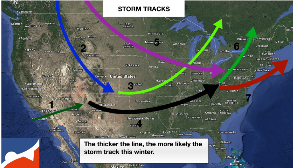
The seven main storm tracks expected this upcoming winter (via NYNJPAWeather) It’s tempting to go above average for snow at the Jersey Shore given all of this, with one or two big snows. However, the coastal storms that do develop off this jet stream will tend to start in Virginia or North Carolina. Even if it is mostly snow for us, they will have a short “runway” as they move northeast to develop heavy precipitation. These are called Miller B storm systems.
The high number of expected storms increases the likelihood of a few significant snowfalls, ranging from 4 to 8 inches. However, without a storm forming off the coast of Georgia or Florida – known as Miller A storms – it’s unlikely we’ll see major snow accumulations.
I expect more than the usual number of tidal flooding and beach erosion days. Most of these should be minor to perhaps moderate issues, but with the weakened state of our beaches in some locations, this will bring worse-than-usual impacts. The good news is the New Jersey Department of Environmental Protection believes the sand that was eroded will return by natural processes next spring. It won’t repair the dune cliffs seen along Jersey Shore; it will only fill in the erosion on the more gently sloping sand.
Being a citizen scientist, for cheap
The Community Collaborative Rain, Hail and Snow Network (CoCoRaHS) is the nation’s largest group of volunteers in the weather community. Each day, over 200 people in New Jersey and thousands across the United States report on how much precipitation they receive.
For $50 upfront (to purchase the rain gauge), your observations will be used by many in the weather community. I look at this constantly during storms and would love to see what you have at your home. In fact, New Jersey’s official state record for most yearly precipitation is from a CoCoRaHS gauge.
We hope to see your reports this winter!
Joe Martucci, a Certified Broadcast Meteorologist and Digital Meteorologist, is the President and Director of Meteorology for Cup A Joe Weather and Drone. You can connect with him at cupajoe.live/.
-

The tropics are about to get weird with storms, what does it mean for NJ?
THURSDAY NIGHT UPDATE: Tropical Storm Humberto and soon to be Imelda may do a rare dance around each other. Known as the Fujiwara effect, they’re uncommon in the Atlantic Ocean and bring a lower than usual forecast for next week. Direct impacts are not expected for NJ, but that still means it could be messy next week.
Never worry about missing severe weather warnings again. Get a recorded call from me when your location is impacted. WeatherCall ensures you stay informed for just $15 a year. Sign up: https://ngorder.wxriskalerts.com/db_app2.php?station=cajx
-
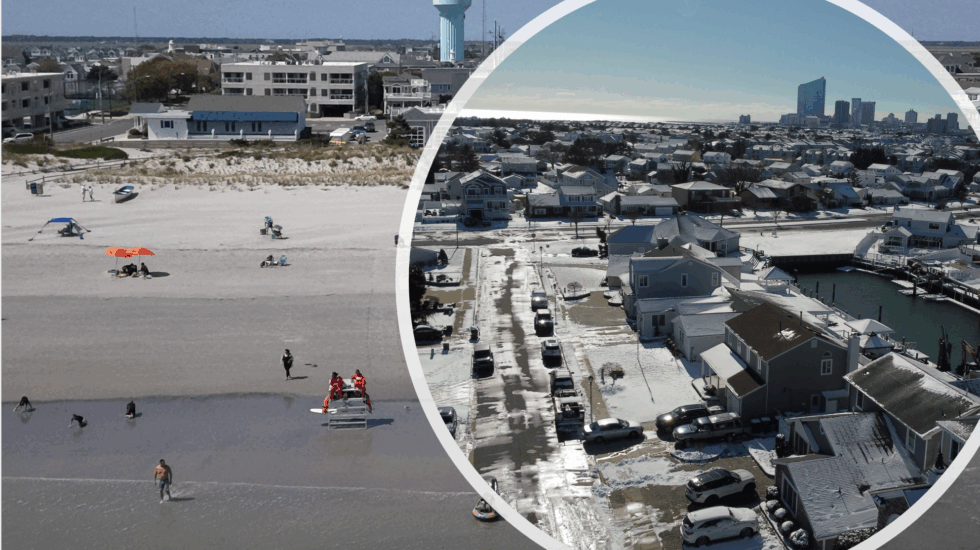
What history can tell us about NJ’s looming 2025-26 Winter
History shows that when July is hotter than usual and August is cooler than usual, like what just happened at the Jersey Shore this year, it’s a good clue about what the coming winter might be like. Here’s why past weather patterns suggest it could be colder than average.
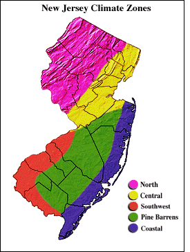
Using information from the Office of the New Jersey State Climatologist, where I did research during my senior year at Rutgers University, I collected average temperature data for every month since 1895. I focused on the Coastal Zone, which the climate office describes as areas east of the Garden State Parkway in Monmouth, Ocean and Atlantic counties, plus almost all of Cape May County.
Via the Office of the New Jersey State Climatologist Snowfall data came from the National Oceanic and Atmospheric Administration for Lower Township, Atlantic City International Airport, Atlantic City and Long Branch. While Atlantic City doesn’t report snowfall anymore, they did from 1874 to the 1950s, which I used for this project.
What do a hot July and a cooler August mean for the Jersey Shore’s winter temperatures?
Going back to 1895, there have been 18 years when a cooler-than-average August followed a hotter-than-average July in the Coastal Zone. That includes 2025 when August wound up 3.2 degrees below average – 31st coolest of the 130 years of record keeping. July was 2.4 degrees above average – the sixth hottest on record. The most recent such period before that was 2017.
Average here is defined as the period of record average from 1895 to 2025. Usually, though, meteorologists use a 30-year average to discuss what is above or below average. The period of record average is cooler than the most recent 30-year average due to the changing climate.
I then investigated what temperatures were for December through March for the months following those July-August stretches. There was a strong signal for temperatures to be colder than our most recent 30-year average. The 17 years broke down like this for the four-month December-March period.
Colder than average for all four months: 3
Three months colder than average: 7
Two months colder than average: 5
One or no months colder than average: 2In other words, 59% of years had all months colder than the 1991-to-2020 average; 12% had no or only one month colder than average.
If September is chilly, too, history says a frigid winter is likely.
September is also likely to be cooler than the period of record average, given the first 10 days of the month, as well as the forecast through at least Sept. 18.
The historical likelihood that winter will be colder than average, based on just those years, is even higher. Of the 12 times this happened, 10 had at least three months between December and March that were colder than average.

The 17 years on record that had a hotter than average July and then a cooler than average August. The blue and yellow boxes indicate temperatures cooler than the 1991-2020 climate average for those months in row 1. Hot July, cool August: Snowy winter at the Jersey Shore?
The history books don’t show a clear link between a super-hot July and a cooler-than-usual August when it comes to snowy winters. Here’s what we found about snow at four Jersey Shore weather stations after 17 winters with that kind of July and August:
Lower Township: 6 winters had more snow, 7 had less.
Atlantic City International Airport: 3 winters had more snow, 9 had less.
Atlantic City: 3 winters had more snow, 4 had less.
Long Branch: 6 winters had more snow, 4 had less.
Each weather station has been around for different amounts of time, so the number of years checked isn’t the same for all. But if you love snow, you might be excited to know that the last two times this happened (the winters of 2017-’18 and 2013-’14), there was more snow than usual. Also, if September is cooler than normal, the chances of a snowy winter go up. Out of 12 years with a hot July, cool August, and cool September, most had more snow than average.

Snowfall totals for four Jersey Shore locations in winters where the previous July was hotter than average and August cooler than average. The purples indicate a snowier than average winter. The grays indicate a less snowy than average winter. Does history matter when it comes to this winter’s forecast?
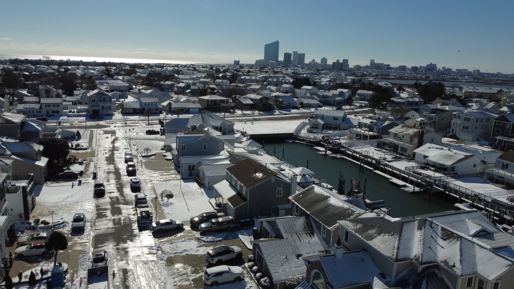
Brigantine’s local roads remained icy two days after the first inch of snow in nearly two years fell on New Jersey in January 2024. (Photo by Joe Martucci) September is in the middle of the August-to-October time frame that long-range forecasters typically use to do their winter forecasts. As part of their research, they look at what the weather in previous springs and summers was like. They then look at what the following winter was like to give them an idea of what to expect. So if, for example, 2017 had conditions similar to 2025, they’d look at the winter of 2017-’18 to give New Jerseyans an idea of what this winter will be like.
They’re called analog years in the weather world. While each forecaster has their own winter formula, analog years are a part of the process, but usually not the main source of information they use.
I don’t do my own winter forecast. However, look for a winter forecast by the top Northeast experts in October. We can read whether they used the winter of 2017-’18 or 2013-’14 as an analog year.
9/11 at the Jersey Shore

Via the City of Absecon In this Shore Local Weather Column, published on Sept. 11, let’s reflect on the tragic events of Sept. 11, 2001. That day brought uncertainty, pain and incredible strength to our nation. As Alan Jackson’s song asks, “Where were you when the world stopped turning?”
If you’re old enough to remember, take a moment to think back on where you were. You might also consider visiting one of the 9/11 memorials along the Jersey Shore. My favorite is in Absecon – it’s powerful, with a lifelike replica of the Twin Towers that’s both beautiful and deeply moving.
Joe Martucci, a Certified Broadcast Meteorologist and Digital Meteorologist, is the President and Director of Meteorology for Cup A Joe Weather and Drone. You can connect with him at cupajoe.live/.
-

50% through summer weather recap: Extreme heat, severe storms & warm water
After such a poor start to our weekend boat and beach season, it feels like summer is just getting into swing at the Jersey Shore. It might be hard to believe but the July 12-13 weekend marked the halfway point between Memorial Day and Labor Day. With six more weekends left to go until the season closes and “Locals Summer” begins, let’s look at the past and future of our weather for the coast.
Jersey Shore weather so far
Summer weekends in 2025 were a bad apple from the start. The cumulative grade point average through July 12-13 is 2.6. That’s a C-plus. In the eight years I’ve done the report card, it’s the worst start on record, and it’s not particularly close, either.
The issue was the weekends from Memorial Day to June 13-15. In order, the letter grades were a C+, D+, C+ and D+. The reason for these gloomy, cooler weekends is part bad weather luck, and part science.
The jet stream, the river of air between 25,000 to 40,000 feet above sea level that separates two air masses, sat right over the Mid-Atlantic. Kinks in the jet stream, called Rossby Waves, created areas of lower pressure. They take roughly a week to pass around the Earth. For us, they fell on the weekends for that spell. Furthermore, the hot and humid weather we all think of doesn’t usually settle in until mid-June. The combination of all of this led to a summer start of poor weather weekends.
That being said, the ever important dry and warm weather for our shore economy was present during the middle of the week early in the season. That may have drawn more people to the shore than usual on those quiet, early June days.
Once we hit June 20-22, the report card was between a “B” and an “A.” That “A” occurred right over the Fourth of July weekend. I was across the pond in Scotland and Ireland then. However, from what I saw online and heard from people, it was the best Independence Day weather weekend in years. We had plenty of sunshine, dew points in the refreshing 50s and decently dry 60s, plus no rain. It made up for lost time early in the season.

The two big weather stories of the summer so far were the extreme heat June 21-26. Then the severe weather on July 8-9.
Atlantic City International Airport reached 102 degrees for two days on June 24-25, the longest 100-degree or greater streak since 2011. On June 23, it tied a record high of 98 degrees, then set new records with the 102-degree days, smashing old records of 99°F and 96°F.
Sen. Frank S. Farley State Marina in Atlantic City hit 93 degrees on June 23, breaking a 1909 record, and tied a 2002 record of 95 degrees on June 24. Both locations also set record high nighttime temperatures. Despite starting off with cool weekends, this summer has been a sizzler.
Since climatological summer began on June 1, it has been the fifth hottest at Atlantic City Marina (records back to 1874), Atlantic City International Airport (records back to 1958) and Estell Manor (records back to 1964) through July 13. These numbers, courtesy of the Southeast Regional Climate Center, part of the National Oceanic and Atmospheric Administration, are over two degrees above the average.
Most of the heat was driven by the overnight low temperatures, which are the warmest on record for Estell Manor and Atlantic City International Airport.
Two weeks later, multiple nights of severe weather struck.
On July 8, a tornado warning was issued for Burlington, Ocean, and Monmouth counties. Storms caused downed wires in New Egypt (Ocean County) and fallen trees in Lakewood (Ocean County).

Radar from July 8’s line of severe thunderstorms that moved through the state. (Via RadarScope) 
A culmonmibus thunderstorm clouds casts a eerie, dark shadow over half of McCullough’s Emerald Golf Course on July 8. (Via Mark Melhorn) On July 9, another storm hit, with a tornado warning for parts of Atlantic and Ocean counties from 10:57 p.m. to 11:30 p.m. Winds hit 58 mph at Cape May-Lewes Ferry and 42 mph in Surf City. A flash flood warning covered the whole coast from Sandy Hook to Cape May, too. Thankfully, no confirmed tornados were seen at the Jersey Shore.
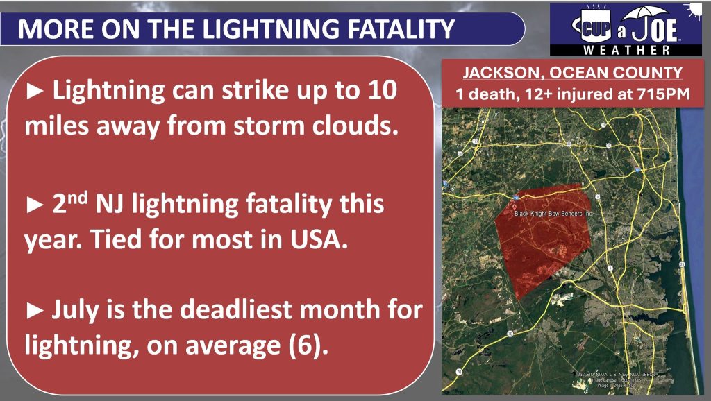
While not right at the shore, there was also a lightning fatality in Jackson Township, Ocean County on July 15. A bolt of lightning struck an archery range, killing one and injuring over a dozen others who were there as part of a Boy Scout event.
The other story since July began is the warm waters. Ocean water temperatures have been in the 70s for most of the month, and in the mid to upper 70s over the July 12-13 weekend. Consider the average water temperature this time of the year is in the upper 60s, and it’s been a treat. It’s also the complete opposite of last summer, where upwelling kept the ocean icy until early August.
What’s the forecast for the rest of summer?
Expect more muggier-than-average conditions for the rest of July. That means dew points in the sticky low 70s or oppressive upper 70s.
In terms of temperatures, I expect more of what we’ve seen this summer for the rest of the month. Temperatures will continue to be above average but driven mainly by the balmy minimum temperatures. Average morning minimum temperatures are in the low 70s in the beach towns and upper 60s inland.
We’ll likely have another inland heat wave (three or more days of 90-degree-or-greater heat) inland this month, perhaps two.
However, that’s typical for us. I don’t see a repeat of the 100s we had in late June.
For August, I’m pleasantly surprised to see particularly good computer model agreement that rainfall stays about average. It’s actually crazy. Models usually differ slightly. However, they are steadfast in dry weather in eastern New England and wet weather in the Appalachian Mountains. Average means eight to nine days of the month with wet weather.
In terms of temperatures, there’s also exceptionally good agreement that the shore counties stay a little bit below the average. Yes, if you’re tired of the summer heat, you should be in for a treat. Don’t expect autumn-like 60s for highs. However, less daytime highs in the 90s sound like a good bet at this time. Later in the month would start to see that hint of crispness in the air.
The rain and temperatures are connected. Assuming the computer models are correct, high pressure would lock in offshore of Maine or Nova Scotia, Canada. Since high pressure spins clockwise, that would mean an onshore wind for much of the month.
That would bring the relatively cooler air from the ocean. At the same time, the ocean waters in the pleasant 70s should continue. East winds shut off the cold upwelling that makes us shiver in the water on the hottest days.

Monthly surface temperature computer model forecast for August, according to the CFS. Most long range forecast models paint a similar picture, with cooler than average air at the Jersey Shore. (Via TropicalTidibts.com) New Jersey’s hurricane season outlook
So far, the state has been tropical cyclone free. Hopefully, we will keep it that way.
According to Colorado State University’s hurricane forecast update on July 9, New Jersey has a 26% chance of a tropical storm being within 50 miles of the coast, with a 8% chance of a hurricane.
That’s a small drop from the initial outlook in April and near the 1880-2020 average.
Still, it’s always good to be hurricane ready.
Have a NOAA Weather Radio. You can buy one easily online. Make sure your phone can receive weather alerts in an emergency.
As we saw in the Texas floods, getting the alerts from the National Weather Service is a matter of life and death sometimes. Also, have a go bag ready with essentials in case you need to evacuate.
Joe Martucci, a Certified Broadcast Meteorologist and Digital Meteorologist, is the President and Director of Meteorology for Cup A Joe Weather and Drone. You can connect with him at cupajoe.live/.
-

April Snow at the Jersey Shore: How often does it happen?
By Meteorologist Joe Martucci
This article appeared in the April 3rd edition of Shore Local Magazine, which you can find here!
April showers bring May flowers, as the saying goes. But what about April snow showers? Some April snow is common at the Jersey Shore, but don’t expect the plows to pass by the blooming cherry trees.
Snow is tough to love, especially the older you are. I visited a homeschool group at Lakewood Chapel in Mays Landing on March 26. When I asked who liked snow, most of the children raised their hands, with a few parents agreeing. But most of the parents didn’t like the snow.
With the arrival of spring, this story plays out often for me, too. April snow especially has a face only Mother Nature could love. (Let me know how you feel about April snow on my social media pages).
Personally, I love snow until St. Patrick’s Day. Then I’m done with it. However, I could make an exception for record-breaking April snow.
How often does the Jersey Shore have snow in April?
For inland parts of the shore counties, 15% of Aprils have had measurable snow, at least 0.1 inches of snow or greater. The most recent time this happened at Atlantic City International Airport was on April 9, 2016. Totals that day, reported via CoCoRaHS, were downright weird.
Snow on April 9, 2016 up the coast in Monmouth County (Via Justin Godynick) First, any measurable snow in April is uncommon. But this was a South Jersey snow special. Ocean City reported 3.2 inches of snow. Estell Manor saw up to 2.9 inches of snow, according to the Office of the New Jersey State Climatologist. Central and northern parts of the state barely had accumulation, even on grass.

Snowfall totals from the April 9, 2016 Snow (Via the Community Collaborative Rain, Hail and Snow Network) The Sen. Frank S. Farley Marina in Atlantic City hasn’t kept snow records since 1956. However, looking at the short term, current data in Margate suggests that measurable April snow in the beach towns has a 5-10% chance of occurring in a given year. Longer-term data in Lower Township also supports this probability. For reference, the northern part of the Jersey Shore jumps up to around 20%.
This all being said, April flurries are common. You can go for a few years in a row with a few festive flakes floating in the spring sky.
Has it snowed enough to be plowable?
For the purposes of this question, we’ll assume that 2 inches of snow is plowable.
Since snow records at Atlantic City Airport began in 1945, there have been only six April days with at least 2 inches of snow or more. In Margate, there has only been one time since records started in 2000 when this has occurred.
Even in a cooler climate period, the Sen. Frank S. Farley Marina in Atlantic City only had three such days during their 1884-1956 snow record-keeping period. All records come from the National Oceanic and Atmospheric Administration. In other words there has, and continues to be a less than 1% chance the snowplows will come around in any given April at the shore.
What year produced the most April snow?
Since measurable April snow is uncommon, and plowable snow is rare, the Aprils with the most snow are largely driven by one day of snow.
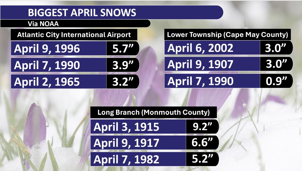
At ACY Airport, 1996 saw the most April snow – 5.7 inches of snow fell that year. However, all of that fell on April 9.
Margate’s highest April snow year was 2016 with 2.0 inches. Again, April 9 was the day when all of that fell at once. Another way to look at it is the April with the most days of accumulating snow.
ACY Airport saw two days of measurable snow in April 1956, 1959 and 1983. Lower Township had two days back in 1907. Meanwhile, Margate only had snow accumulate in April once – in 2016.
Biggest April snows
Here’s a look at the three biggest April snow totals up and down the Jersey Shore.
If you’ve lived in the shore counties your whole life and are over the age of 14, you should remember the 2016 snow.
May snow?
The Jersey Shore never had measurable snow in May during its period of record. Non-accumulating flurries are uncommon, but not rare. I remember when flurries flew on Mother’s Day weekend back in 2020.
Hurricane season forecasts
On the completely opposite side of the weather spectrum, the first hurricane season forecasts will come out this month.
It kicks off on April 3 when Colorado State University releases its outlook for the season. Despite the state being landlocked, it was home to William Gray, widely considered the pioneer of this specialized weather field.
The Weather Channel typically releases its hurricane forecast during the first half of April. So, be on the lookout for that.
Then, the National Hurricane Center will release its forecast in late May. The Hurricane Center manages all tropical watches, warnings and storm-specific forecasts in the United States.
As we go deeper into spring, stay tuned for a few hurricane-related articles here.
-

Understanding Snow Forecasts: Meteorology vs. Weather Apps
Originally appearing on Shore Local News on Feb. 27. Visit my friends at Shore Local here!
By Meteorologist Joe Martucci
Five to seven days before the New Jersey nor’easter that never was on Feb. 20, I received many messages about it. Here’s three examples (edited for clarity):
“How much snow are we getting Thursday? People in school are saying 15 inches.”
“Joe, are we really supposed to get over a foot of snow on Thursday? Apple Weather told me.”
“Someone said we are getting 15-18 inches of snow…”
What happened last Thursday? Snowy coatings south of the Cape May Canal with a gentle breeze out of the northeast.
These three messages were like dozens of others. Messages, comments, and posts to me all circled around the same concept: the generic weather phone app. Using it is fine 75% of the time. However, just like calling a 1-800 number, when you really need an answer, you want a human to help you out.
This doesn’t mean the nor’easter didn’t happen at all. Norfolk, Va. reported 11 inches of snow, Chincoteague Island, Va. off the Delmarva Peninsula reported 6.5 inches, and the Outer Banks of North Carolina reported 3 to 6 inches of snow according to the National Weather Service.

Visible satellite over the Mid-Atlantic after the Feb. 19-20, 2025 nor’easter. Note the bright white in eastern Virginia and North Carolina. That is snow cover. New Jersey, meanwhile, had none (NOAA). I, and every credible meteorologist I know of in the area, did not start putting out snow forecasts until Monday. That’s about 60 hours before any storm was supposed to come. My forecast, even on Monday, was for a lower impact event. No foot-plus forecasts or historic nor’easter for New Jersey.
Now this is not because we meteorologists hunkered down in a basement and all decided to withhold the snow forecast from you. It’s because we know how nor’easters work and the limitations of computer modeling.
Think about this: Meteorologists have to be accurate because they work for the public or their bosses. Phone apps? Not so much. They’re made by companies to make money, not to help people. They just spit out computer guesses with no real risk. That’s why an app might say a foot of snow one day, then an inch the next, and then 6 inches after that.
Meteorologists, like the ones who work for the government or news outlets, are usually seen as people you can trust.
A long time ago, our job started because we wanted to keep people safe. When we say it’s going to snow, most folks believe us more than their phone apps. Our weather predictions help people get ready for big storms – like knowing when to leave their homes or stock up on supplies. Take Superstorm Sandy, for example. People listened to us to figure out what to do, not just some computer message.
Generic phone apps are quick, easy and give you an answer. That’s what we all want in life. I want that in life, too. But as they say, life is not always black or white. It’s just not that easy.
The reason I waited until Monday to issue a snow forecast was because of computer model limitations and an understanding of how the atmosphere works.
Weather predictions past 84 hours use global models. These models cover the whole Earth, about 12,430 miles from pole to pole. The distance from Ocean City, NJ, to Norfolk, Va., is just 1.5% of that, so it’s tiny compared to the model.
Therefore, on Feb. 13, 14, 15 and even 16, it was fair to say that a nor’easter would be around New Jersey on Feb. 20. However, it would have been impossible to pinpoint a snow forecast. Even if the generic weather app were right it would have been pure luck – like throwing a dart in the bullseye blindfolded.
Secondly, the nor’easter didn’t enter the United States’ West Coast until Sunday night to early Monday. That plays a role. When it enters the country, it can be sampled by the National Weather Service’s twice-daily weather balloon launches for weather data. That data then feeds into the weather computer models.
Third was that there was going to be plenty of dry air to the north. This was always going to bring a sharp cutoff in snowfall totals. It was why I thought our third “South Jersey Snow Special” was a good possibility on Monday, despite it not working out that way. But again, when the snow map first came out Monday, the highest snowfall forecast was 1.5 to 3 inches of snow for Atlantic and Cape May counties. Places like Medford and Trenton would see no accumulating snow.
The reality is that 75% of the time, using your generic phone app is fine. If it’s dry, it won’t really matter to us if it’s sunny, or partly sunny, or if it’s 65 degrees or 68 degrees. I get that.
However, when the specifics of the forecast really matter, that’s when a meteorologist comes in. I used to work at the weather consulting company WeatherWorks in Hackettstown. We worked with movie production companies. They needed accurate cloud cover forecasts. A phone app can’t do that. A meteorologist can.
The same goes for snow, hurricanes and coastal flooding. It’s going to take longer to get an answer from us than the phone app, but it has a better chance of being the right answer, and giving you the context you need. That’s why many of us still check in with meteorologists daily, even if the next week will be mild and clear.
Last week I had to call the Internal Revenue Service for something. After dialing the number, I pressed one automated prompt, then another automated prompt that I thought would help me out. It left me without the answer I needed and once the automated prompt ended, the call ended.
After a few tries of different combinations, I reached a very pleasant man in West Virginia. I explained my problem and he helped me out right away.
Human knowledge and context, aren’t going away soon.