
Tag: weather

  • Sunday’s storm mostly misses the Jersey Shore. Thanksgiving is a different story.

    Sunday’s storm mostly misses the Jersey Shore. Thanksgiving is a different story.

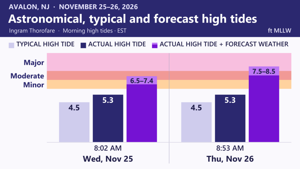
    Thanksgiving morning’s high tide will be the Jersey Shore’s biggest weather problem of the week.

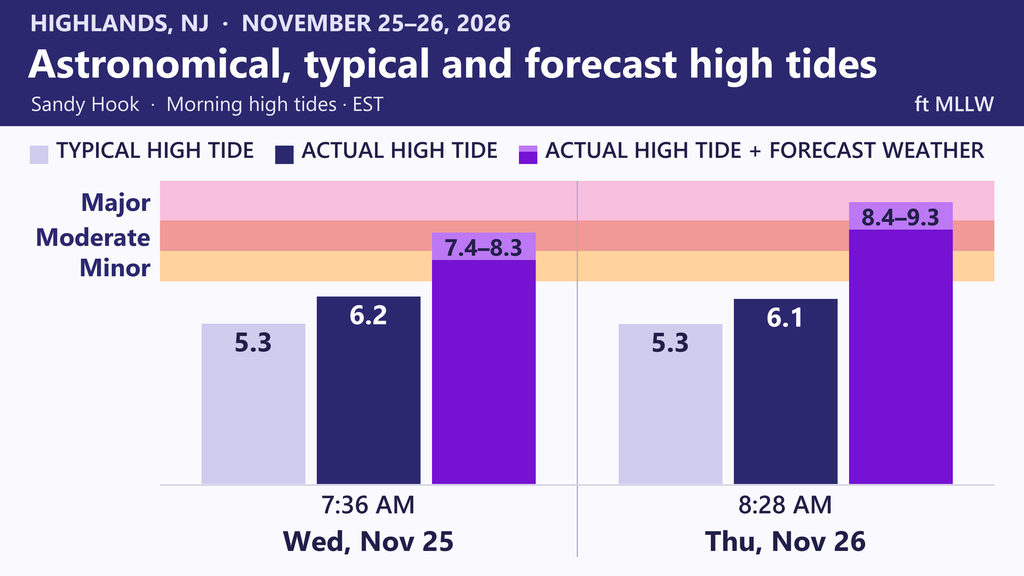
    The Cup A Joe Weather Team expects at least moderate tidal flooding at the Jersey Shore on Nov. 26. Heavy rain and strong winds could also slow holiday travel. Wednesday is the day to travel on trains or planes.

    If you’re heading to or from a beach town, aim to make the trip by Wednesday evening. During Thursday morning’s high tide, water will cover low roads and cut off some routes between Shore neighborhoods and the mainland.

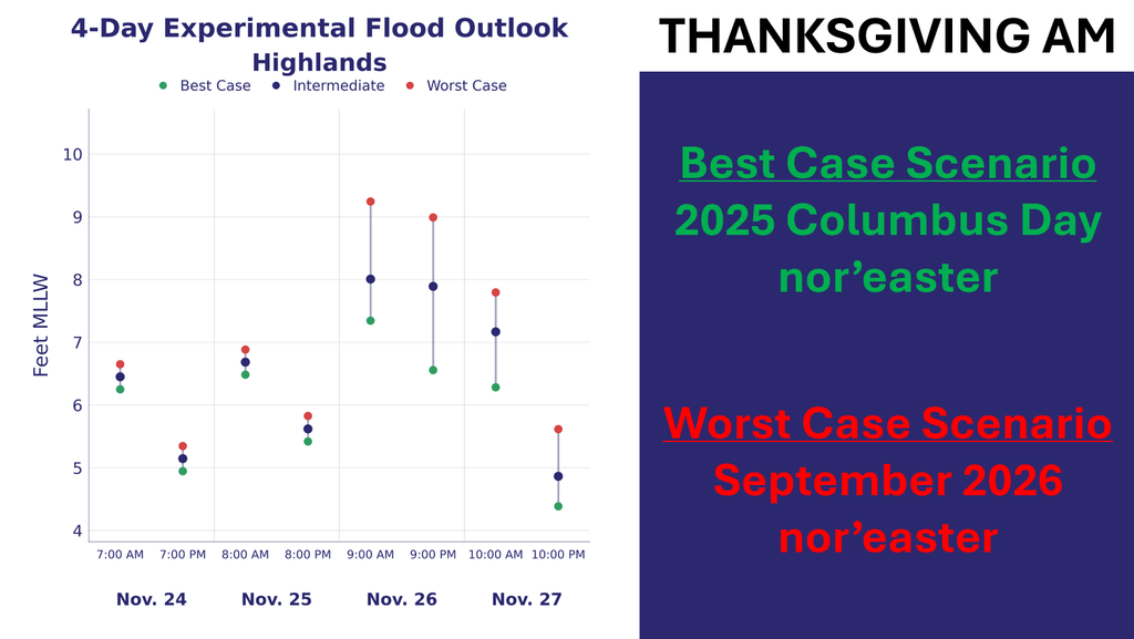
    At a minimum, tidal flooding will look similar to the Columbus Day nor’easter just last year in 2025. That will be water in some unraised homes and businesses. Up to 18″ of water will be on the lowest lying areas, with a few inches of water in places that don’t typically get it dozens of times a year.
    Heavy rain and strong winds could also delay flights Thursday. How hard it rains and how strong the winds get will depend on the storm’s track and strength. It’s still too early to say whether gusts will cause power outages. Cup A Joe Weather plans to share a first look Monday and a more detailed tidal flooding forecast Tuesday.

    Friday looks mostly dry but windy, and flooding could return at high tide even after the rain ends. Saturday looks dry.

    Before Thanksgiving, a smaller storm will pass offshore Sunday night. Monmouth and Ocean counties have the best chance of rain between 5 and 10 p.m., but most places will get less than half an inch. Gusts could top 30 mph, and rough surf could erode some beaches.

    Monday morning’s high tide could bring minor flooding to a few spots in Cape May County and around Barnegat Bay. Inland, temperatures should climb well into the 60s Monday before a cold front moves through that night. Tuesday will feel much colder, with a brisk northwest wind and highs near 50.

    Know More

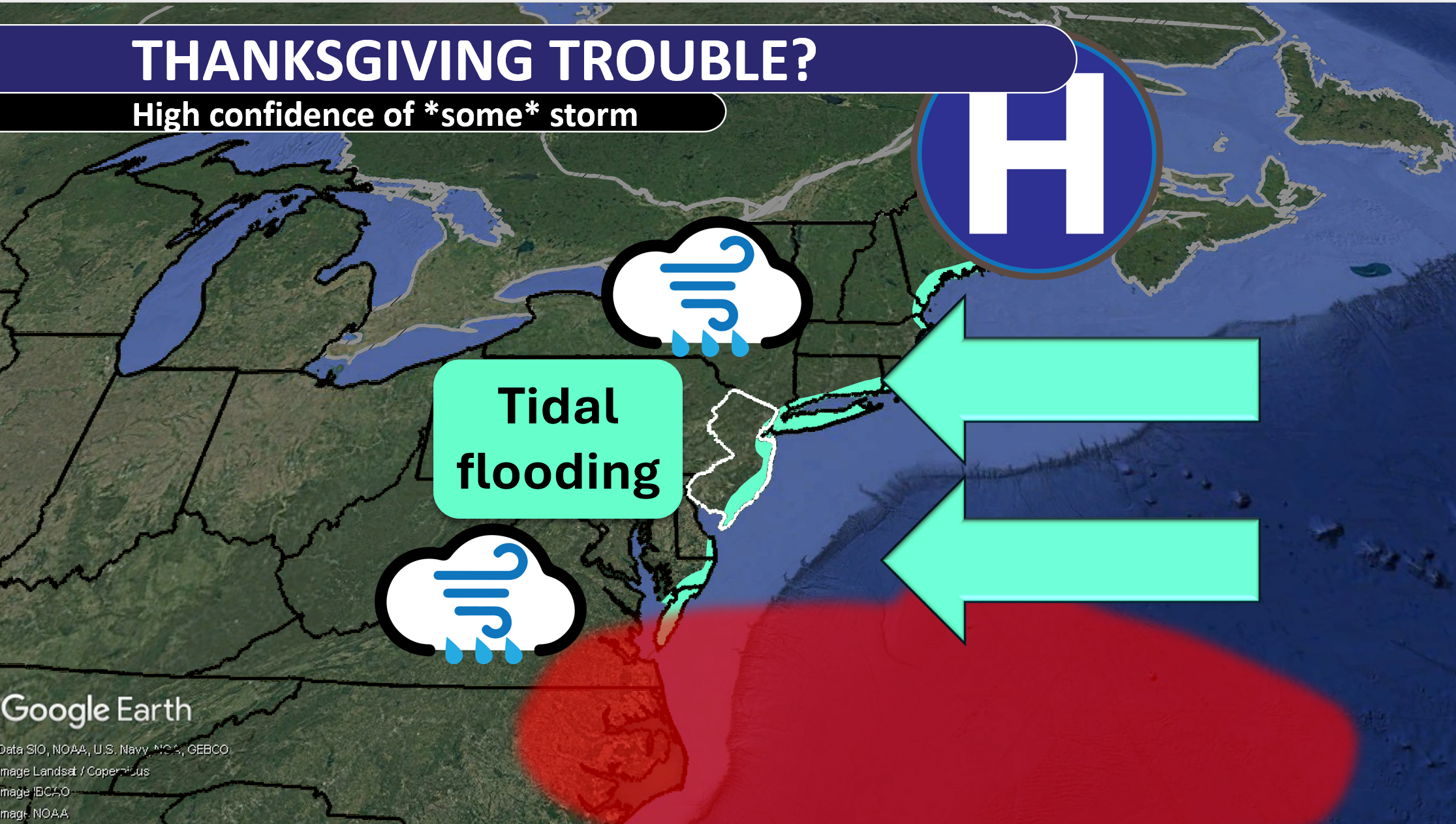
    For Thanksgiving, a blocking high to the north and a low approaching from the south could sustain northeast winds across a long fetch, the distance wind blows over water in roughly the same direction. Persistent onshore flow can raise water levels above the predicted astronomical tide. That extra water is storm surge. Add it to the astronomical tide and you get the storm tide.

    One reasonable ShorelySafe high-end historical comparison is the January 2016 blizzard. NOAA’s Cape May gauge at the ferry terminal reached 9.0 feet above mean lower low water during that storm. Flood thresholds vary by gauge. At moderate stage, many roads can become impassable and vulnerable buildings can sustain damage.

    Sunday morning’s dense fog in parts of Monmouth and Ocean counties was advection fog. When warm, moist air crosses cooler water, the air can cool to its dew point. If the incoming dew point is above the sea surface temperature and the air spends enough time over the water, tiny droplets can form. Onshore winds can then carry that fog inland.
  • Why we’re concerned about tidal flooding Thanksgiving in NJ

    Why we’re concerned about tidal flooding Thanksgiving in NJ

    A coastal storm is threatening on Thanksgiving that would make your turkey time brined in significant salt water from tidal flooding.

    The combination of the king tide and a very strong signal for onshore winds has us tracking the tidal flooding siutation closely, both at Cup A Joe Weather and for our ShorelySafe flood and weather consulting towns.

    Wednesday brings a king tide, NOAA’s term for an unusually high tide. Around a full or new moon, the sun, moon and Earth line up. The pull of the sun and moon combines to produce higher high tides. When the moon is closer to Earth, its pull is stronger, and the tide can rise even higher.

    At Sandy Hook, Wednesday’s astronomical high tide alone will be within three inches of flood stage. The astronomical tide is the water level expected from the pull of the moon and sun, before wind or other weather effects come into play.

    September’s nor’easter shows how much water a storm can add. On the morning of Sept. 26, 2026, the astronomical high tide in Atlantic City was about 4.8 feet. The tide gauge measured about 7.8 feet, roughly 3 feet higher. The Jersey Shore all saw a similar rise.

    On Thanksgiving, tides will still be running nearly as high as Wednesday as a coastal storm approaches from the south.

    However, a familiar set up will occur. Drying high pressure will be situated in Eastern Canada. This will block the coastal low pressure system from moving out to sea quickly.

    The result are onshore winds for the Jersey Shore. That will pile water from the ocean into the bays and tidal rivers, which then threaten to flood land.

    It’s too early to tell just how much tidal flooding there will be, let alone rain or wind. Even if there is no rain, tidal flooding still is a threat every morning from Nov. 25, through Thanksgiving and into Black Friday.

    In fact, our in-house flood forecast is showing a reasonable best case scenario as a moderate stage tidal flood Thanksgiving morning, the kind that happens four or five times a year. Driving around the barrier islands will be difficult with water on the roads. Water would get into unraised, susceptible buildings and plenty of garages.

    A reasonable worst case scenario is a repeat of the September nor’easter. The major stage tidal flooding is only see a couple of times a decade.

    If your street usually floods, move your car to higher ground before high tide. If you’re visiting family, check the tide time for their town and leave extra time for a detour.

    Our winter forecast expects well above average tidal flooding, with another significant flood like September well within possibility.

    On Monday you can expect to hear from us as to whether rain and strong winds will accompany the tidal flooding. Expect an exact tidal flood forecast for Thanksgiving morning Tuesday.

  • Beautiful Saturday, a little stormy Sunday – Monday at the Jersey Shore

    Beautiful Saturday, a little stormy Sunday – Monday at the Jersey Shore

    🎉SATURDAY’S FORECAST | Beautiful now, a little stormy Sunday. Rain begins 12-3PM. We believe the worst of the storm will stay just offshore but miles will make the difference.

    We also get into a more powerful storm for Thanksgiving.

    ShorelySafe® helps towns and organization forecast tidal flooding 84 hours ahead, reduce flood risk and lower insurance costs with property-level flood intelligence.

    Request a meeting: www.shorelysafe.live

  • Tidal Flooding Talk links up with Atmosphere podcast for flooding special

    Tidal Flooding Talk links up with Atmosphere podcast for flooding special

    LISTEN TO TIDAL FLOODING TALK HERE

    The sun is shining. Rain is nowhere in sight. Yet salt water is covering the road.

    For people living along the Jersey Shore and in Charleston, South Carolina, that scene is familiar. But visitors and new residents can be caught off guard when the ocean interrupts an otherwise beautiful day.

    In a collaboration episode between Atmosphere and Tidal Flooding Talk, two meteorologists explore how coastal flooding shapes their communities. Emily Gracey, meteorologist and host of the Atmosphere podcast in Charleston, joins Joe Martucci, meteorologist and host of Tidal Flooding Talk in New Jersey, to compare experiences and discuss how communities are adapting.

    Their conversation reveals a shared challenge: helping people understand flooding before it reaches their street.

    When water arrives without rain

    Gracey describes Charleston as a place where water is woven into daily life. Rivers, tidal creeks and bridges shape how people travel. On some sunny days, high tides also determine which roads they can use.

    She explains that northeast winds, combined with higher tides around a full or new moon, can bring water onto familiar trouble spots downtown.

    Charleston’s history adds another layer. Gracey notes that parts of the city were built over former creeks and wetlands. Those decisions still affect where water collects and how easily it drains.

    Along the Jersey Shore, Martucci describes a similar problem with a different layout. Many communities sit on barrier islands, with the ocean on one side and a bay on the other. He explains that tidal flooding often arrives from the bay side.

    The flooding summer visitors miss

    Timing can make the risk harder to understand.

    Many Jersey Shore visitors know the coast best between Memorial Day and Labor Day. Martucci points out that they may miss the flooding associated with fall and winter storms.

    That gap matters when a vacation spot becomes a permanent home. Someone familiar with summer beach weather may have little experience with water covering neighborhood streets.

    Gracey sees a similar divide in Charleston. Longtime residents often know which routes flood, while newcomers are still learning what living in the Lowcountry means.

    How communities are responding

    Gracey says drainage improvements have helped some Charleston roads during her years in the city. She also discusses efforts inspired by Dutch water management, including making room for water to flow through the landscape.

    In New Jersey, Martucci highlights the New Jersey Coastal Coalition’s role in helping towns share knowledge and coordinate flood education.

    The episode also explores a difficult question: Will repeated flooding eventually change where people choose to live? Neither host offers a simple answer. Both describe communities where the appeal of coastal living remains strong.

    Their discussion brings the issue back to everyday life: knowing your neighborhood’s flood patterns can change how you understand a clear forecast and a rising tide.

  • November Tornado and Record Hail Strike New Jersey

    November Tornado and Record Hail Strike New Jersey

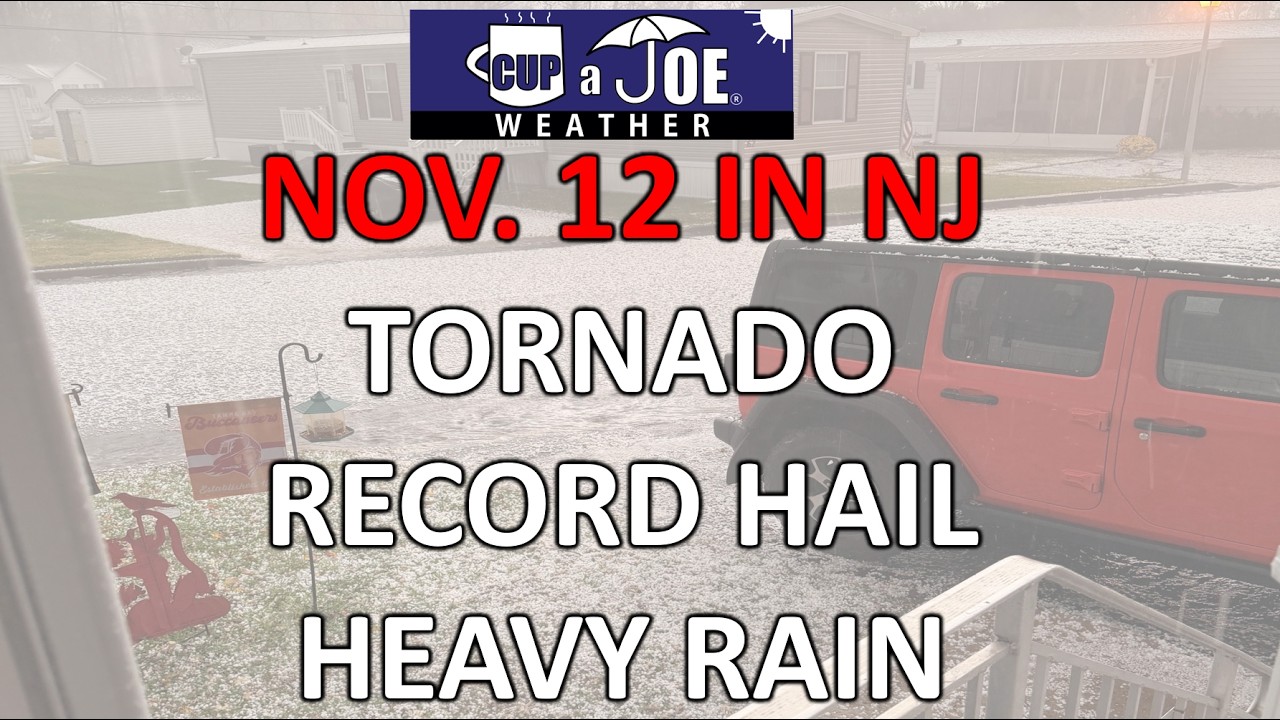
    New Jersey’s November weather took a turn Thursday, Nov. 12, as thunderstorms produced a confirmed tornado, a waterspout, large hail and heavy rain. From Burlington County to the Jersey Shore, the storm brought hazards more often linked with spring and summer.

    Subscribe to our YouTube channel here

    For Monmouth and Ocean counties, the afternoon included hail-covered ground and flooded roads. The event also added a new chapter to New Jersey’s November weather history.

    Chesterfield tornado and Salem County waterspout

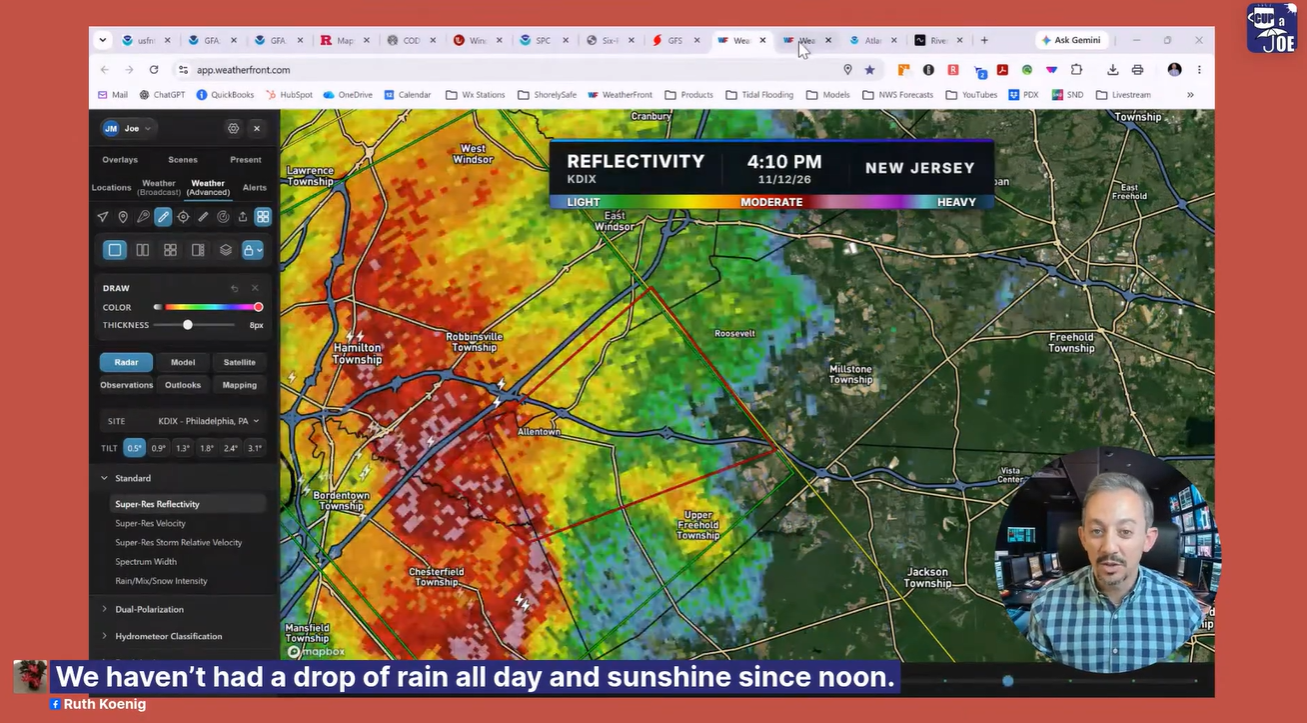
    The National Weather Service confirmed an EF1 tornado in Chesterfield, Burlington County, with estimated peak winds of 100 mph. A waterspout was also reported near Penns Grove in Salem County.

    Across the Delaware River, a separate tornado touched down near Wilmington, Delaware. These reports showed how dangerous the region’s storms became during the afternoon.

    Record November hail

    In the Lakehurst area of Ocean County, hail reached 1.75 inches across, about the size of a golf ball. Cup A Joe Weather’s review of NOAA records found this was New Jersey’s largest November hail on record, surpassing 1.50-inch reports from Burlington and Mercer counties in 1977.

    Quarter-sized hail also fell in parts of Monmouth and Ocean counties. Along the Interstate 195 corridor, hail piled up enough to make some spots look snow-covered.

    Heavy rain at the Jersey Shore

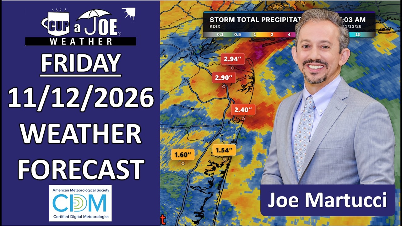
    Heavy rain added another problem, especially in eastern Monmouth and northern Ocean counties. Rainfall reached around 2 to 4 inches in the hardest-hit areas, leaving water across roads. Fallen leaves blocking storm drains made drainage problems worse.

    Drivers faced several hazards at once: heavy downpours, poor visibility, hail and standing water.

    Why this happened in November

    A warm front moving north and a strengthening storm system helped create conditions for rotating thunderstorms. The Storm Prediction Center raised the tornado probability to 5% for part of New Jersey.

    November tornadoes are unusual here, but they have happened before. On Nov. 16, 1989, seven tornadoes struck New Jersey in one day. Thursday offered another reminder that severe weather season does not end when summer does.

    Know More

    Thursday’s storm setup combined instability, lift and wind shear. Instability allows air to rise and fuel thunderstorms. A frontal boundary provides lift, while changes in wind speed and direction with height can help storms organize and rotate.

    The northward-moving warm front was especially important. Winds near a warm front can change sharply over short distances, creating a favorable corridor for storm rotation. The strengthening low-pressure system added to the evolving wind field.

    The Energy Helicity Index, or EHI, combines CAPE, a measure of instability, with storm-relative helicity, which describes the wind profile’s potential to support a rotating updraft. Higher values can flag environments favorable for supercells. EHI is guidance, however; it does not confirm a tornado or guarantee that one will develop.

    The Storm Prediction Center’s 5% tornado outlook also needs context. It represents the probability of a tornado occurring within 25 miles of a point in the outlined area. It does not mean 5% of the state will experience a tornado.

    Large hail requires strong updrafts that suspend growing ice particles in the cloud. Supercooled water droplets freeze onto those particles, adding mass until they fall out of the updraft. Lakehurst’s 1.75-inch hail showed that substantial hail growth occurred despite the late-season date.

    At ground level, heavy rainfall and leaf-clogged drains created another hazard. Blocked drainage can worsen street flooding even where nearby waterways remain within their banks.

  • Rutgers vs. Nebraska Football Weather Forecast (11/14/2026)

    Rutgers vs. Nebraska Football Weather Forecast (11/14/2026)

    This is November football on the Banks. Cold air, a stiff breeze and Nebraska coming to town. Rutgers fans know the assignment: get loud.

    Saturday’s 12:30 p.m. kickoff follows a cold morning in the tailgate lots. At 8 a.m., temperatures will sit near 35 degrees, with wind chills around 30.

    Northwest winds will blow around 10 mph, with gusts in the 20s. Temperatures will reach the mid-40s during the game under a mix of clouds and sun. A quick sprinkle is possible, but expect mostly dry weather.

    There’s some home-field history to like, too. Cup A Joe Weather’s Rutgers football weather archive shows winning records in dry home games in the 40s and games with gusts in the 20s.

    Bring the layers. Bring the noise. Make Nebraska earn every yard.

  • It’ll barely reach 50 degrees this weekend at the NJ Shore

    It’ll barely reach 50 degrees this weekend at the NJ Shore

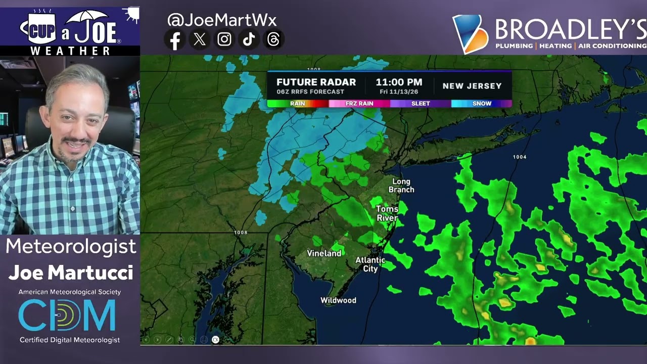
    🌧️FRIDAY’S FORECAST | Cold, raw, wet, breezy. All of it. It feels like winter is around the corner! You’ll notice it this weekend with highs barely at 50F

    Let’s talk about that, and recap a wild day of weather Thursday.

    🏈 Your Rutgers tailgate headquarters! Parking at St. George is only 500 yards from SHI Stadium and features 500+ spots, clean restrooms, and quick access to River Road. It’s where Joe parks! Purchase at: www.rutgersparking.com .

  • A tornado is possible in NJ on November 12. It’s happened in November before.

    A tornado is possible in NJ on November 12. It’s happened in November before.

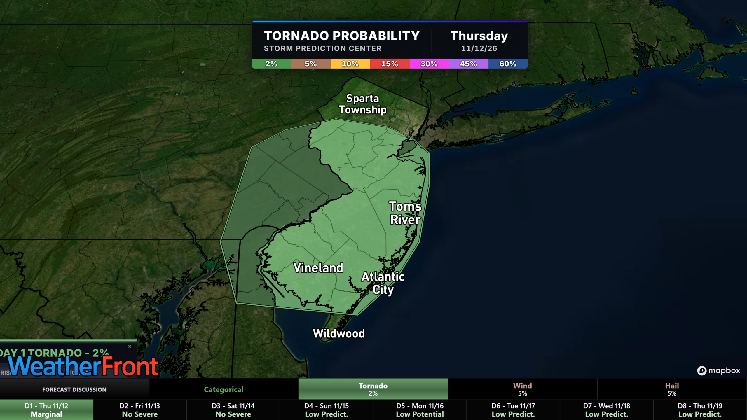
    November may feel like an unusual time to talk about tornadoes, but New Jersey has a low risk for one Thursday, Nov. 12.

    If you live along the Jersey Shore, keep an eye on the weather. Monmouth, Ocean and Burlington counties stand out in the forecast as areas where heavier showers or thunderstorms could develop. The threat could reach other parts of central New Jersey, too.

    NOAA’s Storm Prediction Center has outlined a 2% tornado risk for parts of the region. That is low, but it means a tornado cannot be ruled out.

    Forecast models show winds that could support rotating storms. That does not mean a tornado will form. It does mean any stronger thunderstorm deserves attention.

    While most people connect tornadoes with spring and summer, New Jersey has seen them in November before. On Nov. 16, 1989, seven tornadoes touched down across the state, per the Office of the New Jersey State Climatologist.

    For your Thursday plans, stay aware of changing conditions and check for forecast updates. Most communities may avoid severe weather, but a low risk still deserves your attention.

  • NJ tornado possible Thursday, COLD air to follow

    NJ tornado possible Thursday, COLD air to follow

    THURSDAY’S FORECAST | It’s a weird day. We have a storm but it’s too little, too late for big impacts (thankfully). We have a severe weather threat, including a tornado, but it’s probably OK. Then, we get into a cold stretch where morning lows stay below 32F inland. *That’s weird* compared to what we’ve seen.

    When severe weather hits trust Broadley’s Plumbing, Heating & Air Conditioning for emergency service. Call 609-264-3683.