
The Monthly Weather Roundup is sponsored by Jennifer Ansbach Coaching / The Cozy Thesis — helping students and adult learners Write. Revise. Rise. Learn more at JenniferAnsbach.com.
New Jersey’s September weather broke the usual patterns. It began with a brisk chill. Then it shifted back to summer warmth. It’s one of only a few times on record when the second half of September was warmer than the first half. Overall, temperatures ended up a bit above average.
Dave and Joe then noted drought warnings in northern areas. Coastal regions faced heavy rain. Eroding beach sands now threaten winter storm defenses. They also discussed Hurricane Sandy’s 13th anniversary and whether memories of the storm are fading. Stay tuned for updates on hurricane risks and stunning fall foliage.
Recap the month of weather that was. It’s all Jersey, with two of Jersey’s best weather guys. New Jersey State Climatologist Dr. Dave Robinson as well as Meteorologist Joe Martucci, owner of Cup A Joe Weather and Drone take you through the temperatures, rain, snow, coastal flooding and much more. New episodes come out around the beginning of every month.
Cup A Joe Weather and Drone: www.cupajoe.live
NJ Climatologist’s Office: www.njclimate.org
Tag: weather
-

Absurd temperature swings in NJ | September 2025 Monthly Weather Roundup
-

The Fujiwhara Effect: When 2 tropical cyclones collide
This article initially appeared in Shore Local News on 10/2/2025. The article was update to include more current information from Imelda and Humberto on 10/2/2025
Last week, I mentioned on my digital and social weather channels that Hurricanes Humberto and Imelda could undergo a rare interaction called the Fujiwhara Effect.
Humberto and Imelda partially made this happen, but not completely. Either way, it doesn’t matter for our Jersey Shore weather forecast. A powerful arctic, high-pressure system kept the rain away from these two storms. However, there were gusts to 40 mph and coastal flooding on Oct. 1 and bad surf continues into the weekend.
The Fujiwhara Effect, like polar vortex, heat dome and derecho before it, brings a new weather word into public discourse. And for your Shore Local meteorologist, it means I get pumped to explain a new-to-many weather phenomenon.
What is the Fujiwhara Effect?
“The tendency of two nearby tropical cyclones to rotate cyclonically about each other as a result of their circulations’ mutual advection,” The American Meteorological Society’s Glossary of Meteorology says. However, let us break that down even more.
Think of the Fujiwhara Effect as a square dance. Instead of pairs of dancers, they are pairs of tropical storms or hurricanes.
In square dancing, pairs of dancers spin and move in patterns together. The same is true with the Fujiwhara Effect. Instead of a caller’s instructions, though, storms follow nature’s rules.
Technically, the Fujiwhara Effect happens when storms are within 900 miles of each other’s circulation. That is the distance from Ocean City, N.J., to Tampa, Fla. That is not much in the vast expanse of the Atlantic Ocean.
The two storms’ counterclockwise (Northern Hemisphere) or clockwise (Southern Hemisphere) winds will start to spin closer to each other. Once they are about 200 miles apart, one of three scenarios happens:
1. The larger storm will absorb the smaller storm into its circulation.
2. The two storms will merge, creating one more powerful storm.
3. Both storms will weaken due to the increase in wind shear or change of wind direction with height.
The Fujiwhara Effect is named after Sakuhei Fujiwhara, a Japanese meteorologist who first described this phenomenon as a theory in a 1921 research paper. Turns out his theory was correct.
Where does the Fujiwhara Effect occur most often?
The northern Pacific Ocean is the place where it happens the most, the American Meteorological Society reports.
The Pacific Ocean, specifically the western Pacific Ocean, is the world’s most active tropical cyclone basin, thanks to its very warm water and humidity. Plus, since the Pacific Ocean is the world’s largest ocean, more storms can simply spin around there, and potentially come into contact with each other.
It is rare to have the Fujiwhara Effect in the Atlantic Hurricane Basin. Records are not kept on them, but they happen only once every couple of years. Compared to the Pacific Ocean, there is less area for tropical storms or hurricanes to develop.
Also, our ocean has just one main storm track: Off the West Coast of Africa to the Caribbean Islands, turn north between the United States East Coast and Bermuda, and then northeast into the northern Atlantic Ocean. This gives less opportunity for storms to cross paths.
Notable Fujiwhara Effect storms
The Fujiwhara Effect likely took place in the Atlantic Hurricane Basin in 2016 when Hurricane Matthew and Tropical Storm Nicole interacted. They did not fully dance with each other, however, Matthew’s path shifted a bit, which brought major flooding to the East Coast of Florida.
The last time on record that Atlantic storms underwent a full Fujiwhara Effect was in 1995 with Hurricanes Iris and, fittingly for this article, Humberto. On Aug. 23, 1995, Hurricane Iris was on a northern path from the Lesser Antilles in the tropical Atlantic Ocean. Then it interacted with Humberto. The Fujiwhara Effect took place, jolting Iris 300 miles to the east.
Both storms weakened with the Fujiwhara Effect. After the interaction, Iris was downgraded to a tropical storm, while Humberto was downgraded from a Category 2 to a Category 1 hurricane.
In the eastern Pacific Ocean, closer to North America, Hurricanes Hilary and Irwin in July 2017 showed a good example of the Fujiwhara Effect when the two made a full pivot around each other as they moved north up the Mexican coastline.
The storms did not merge. They ended up weakening, in part due to the Fujiwhara Effect, and in part due to moving over cooler water.
Joe Martucci, a Certified Broadcast Meteorologist and Digital Meteorologist, is the President and Director of Meteorology for Cup A Joe Weather and Drone. You can connect with him at cupajoe.live/.
-

😎High pressure DOMINATES | Thursday, 10/2/2025 NJ Weather Forecast
It’s cool, it’s crisp, it’s calm, it feels like Fall! The NJ Forest Service just released their forecast on when the fall colors will be brightest. We talk about that plus a Locals’ Summer special in the 7-day.
Follow my work: www.cupajoe.live
Jolt your brand, advertise with me: joe@cupajoe.live -
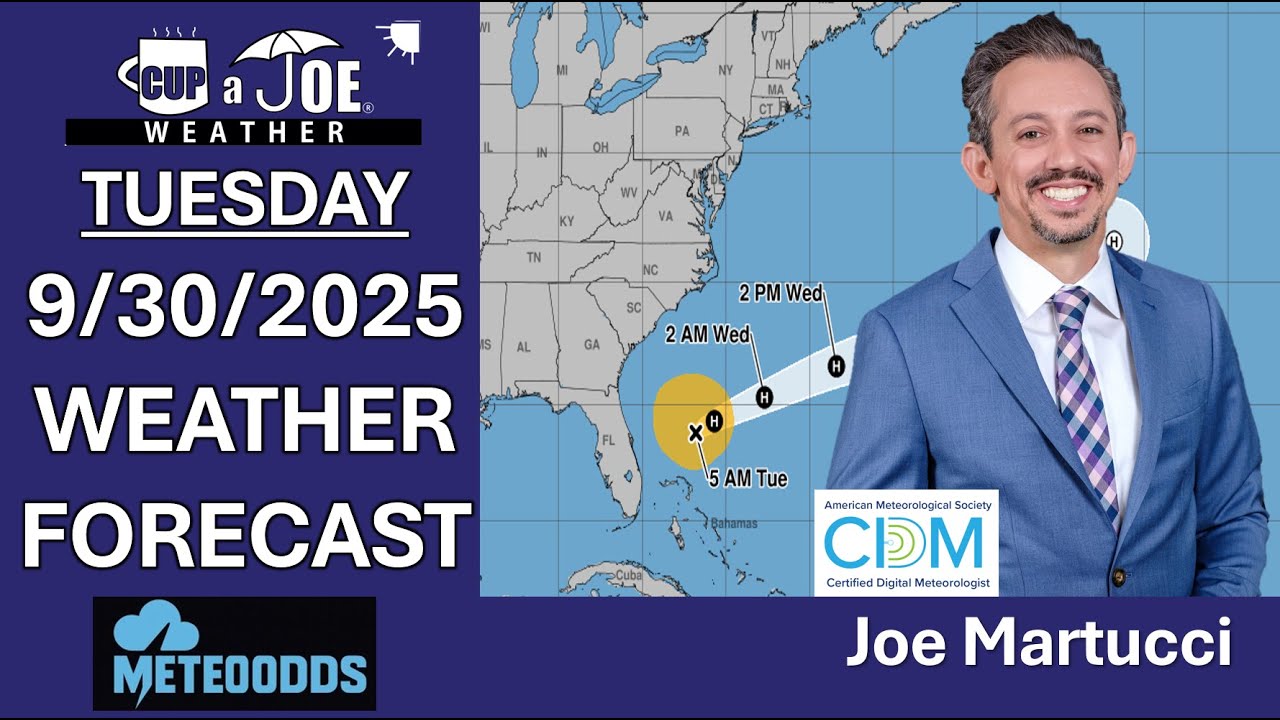
Dry on land, ROUGH ocean, thanks to Imelda | Tuesday, 9/30/2025 NJ Forecast
📹TUESDAY FORECAST | T.S. Imelda will churn up our ocean and, eventually, bring coastal flooding and strong winds. Otherwise, though, we’re dry! Dominate your fantasy leagues and bets with weather-driven data.
MeteoOdds gives you innovative tools, player/game weather impacts, and detailed forecasts. Join FF+ by using the code WEATHER and get 50% off, for life! Turn forecasts into fantasy wins — only at www.meteoodds.com.
-
Despite the quiet, there’s still plenty of 2025’s hurricane season to go
This article initially appeared in Shore Local Magazine on 9/25
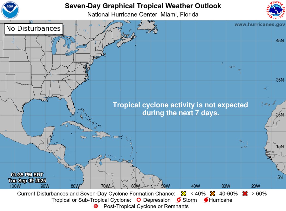
Thankfully, hurricane season has remained quiet. No major storms have made landfall in the United States, or really anywhere. By the numbers, this is a quieter-than-average year so far. However, don’t be lulled into complacency.By late September, the Atlantic Hurricane Season typically reaches its 10th or 11th named storm on average. That would be the “J” or “K” named storm. That’s “Jerry” or “Karen” according to the World Meteorological Organization, which is the group that determines storm names.
Through Sept. 26 we’re only on Humberto, the eighth storm. She is expected to spin east of Bermuda, well away from the East Coast. New Jersey has seen elevated surf and a risk for rip currents. However, there are no direct impacts.
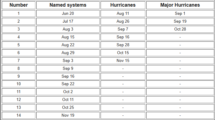
Average progress of the Atlantic Hurricane Season from 1991-2020. Image via the National Hurricane Center. By the Sept. 27-28 weekend, Imelda. That would take us to the ninth named storm. That’s closer to average, but still on the quiet side.
Now is not the time to be lulled into a sense of security, though. The forecasts for a more-active-than-usual season still have time to come true.
Sixty percent of tropical activity occurs after Sept. 10 in the Atlantic Ocean, according to the National Hurricane Center, a government agency in Miami, Fla. But it came and went with a whimper. This has been one of only a handful of years when there were no active storms in the Atlantic Hurricane Basin during the season’s peak.
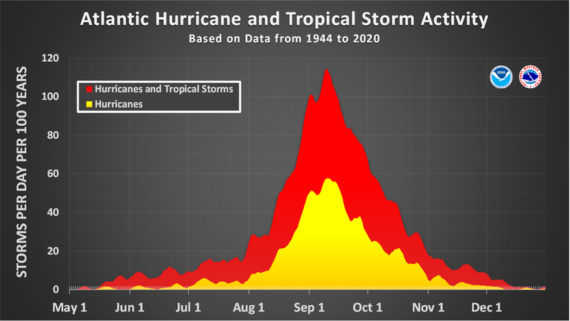
By late September there is still plenty of hurricane season to go. Sandy, you will recall, made landfall near Brigantine on Oct. 29, 2012. The hurricane season officially runs from June 1 to Nov. 30, so it’s a backloaded season.
Here’s a look at the latest hurricane forecasts from agencies I highly respect. These forecasts include what has already happened. Through Sept. 22 there have been seven named storms, two hurricanes and one major hurricane – Category 3, 4 or 5 storm.
National Hurricane Center (from Aug. 7):
- 13 to 18 named storms
- 5 to 9 hurricanes
- 2 to 5 major hurricanes
Colorado State University (from Aug. 6):
- 16 named storms
- 8 hurricanes
- 3 major hurricanes
United Kingdom Met Office (from Aug. 1):
- 16 named storms
- 6 hurricanes
- 4 major became
There’s also something called Accumulated Cyclone Energy (ACE). I like to use this, and you’ll see people using this more often in the future. ACE measures hurricane season energy by adding up storm strength and duration score as it’s going on.
Colorado State University, as well as the United Kingdom Met Office, issues forecasts for ACE. Both predict a 140-146 ACE index.
This is all at or just above average. These forecasts still predict that all the activity we’ve had since hurricane season started will be duplicated between now and when the season ends two months from now; other words, just as hurricane season usually goes.
Have your evacuation plan and get your go bag ready in case you need to leave. In the best case scenario, it will collect dust and stay dry during a quiet New Jersey hurricane season.
Joe Martucci, a Certified Broadcast Meteorologist and Digital Meteorologist, is the President and Director of Meteorology for Cup A Joe Weather and Drone. You can connect with him at cupajoe.live/.
-

MUGGY weekend ahead | Friday, 9/26/2025 NJ Weather Forecast
FRIDAY’S FORECAST | Good morning! The muggy meter is still high but it won’t be as swampy as Thursday. Look for a mostly dry weekend ahead, with one time for rain. Then, I’m still figuring out how the “Fujiwhara effect” of Hurricane Humberto and soon to be Imelda will impact NJ.
Tune in for the forecast! Follow my work: www.cupajoe.live
Jolt your brand, advertise with me: joe@cupajoe.live
-

The tropics are about to get weird with storms, what does it mean for NJ?
THURSDAY NIGHT UPDATE: Tropical Storm Humberto and soon to be Imelda may do a rare dance around each other. Known as the Fujiwara effect, they’re uncommon in the Atlantic Ocean and bring a lower than usual forecast for next week. Direct impacts are not expected for NJ, but that still means it could be messy next week.
Never worry about missing severe weather warnings again. Get a recorded call from me when your location is impacted. WeatherCall ensures you stay informed for just $15 a year. Sign up: https://ngorder.wxriskalerts.com/db_app2.php?station=cajx
-

Tornado possible now, tropical trouble next week? | Thursday 9/25/2025 NJ Weather Forecast
THURSDAY’S FORECAST | Well, our weather got busy in a hurricane. A tornado is *not ruled out* later today. More than likely you get rain and swampy weather. The weekend is mostly fine. Tropical trouble next week? Let’s talk.
Never worry about missing severe weather warnings again. Get a recorded call from me when your location is impacted. WeatherCall ensures you stay informed for just $15 a year. Sign up: https://ngorder.wxriskalerts.com/db_app2.php?station=cajx
-

Thunderstorms, tropical weather RETURN this week | 9/23/2025 NJ Weather Forecast
Dominate your fantasy leagues and bets with weather-driven data. MeteoOdds gives you innovative tools, player/game weather impacts, and detailed forecasts. Join FF+ by using the code WEATHER and get 50% off, for life! Turn forecasts into fantasy wins — only at www.meteoodds.com.
TUESDAY’S FORECAST | It’s our first full day of astronomical fall but it sure feels like the summer we haven’t had this month. Humid air, thunderstorms in the forecast and hurricane season is heating up. How much rain you see this week depends on where you are! I got it all here.
Follow my work: www.cupajoe.live
Jolt your brand, advertise with me: joe@cupajoe.live
-

“Average” Fall Foliage expected at the NJ Shore in 2025
This article initially appeared in Shore Local Newsmagazine on 9/18/2025.
It will be an “average” year for fall foliage colors this season, the New Jersey Forest Service says. The combination of a wet, late spring; a dry August and September, and cool nights is the key to the 2025 forecast.
Mike Zsoldos, assistant regional forester for the New Jersey Forest Service, met with me at Double Trouble State Park, located in Bayville, Ocean County, for an interview and drone footage.

Double Trouble State Park (front), with the Barnegat Bay, the Barnegat Peninsula and the Atlantic Ocean in the distance (Photo by Joe Martucci) The park is right off of Garden State Parkway Exit 77. It’s a scenic Pinelands forest known for its Atlantic white cedar trees. Zsoldos said several of the already dwindling trees were destroyed in Superstorm Sandy. However, due to the Atlantic White Cedar Restoration Project, the trees are coming back, helping to offset ground and water pollution.
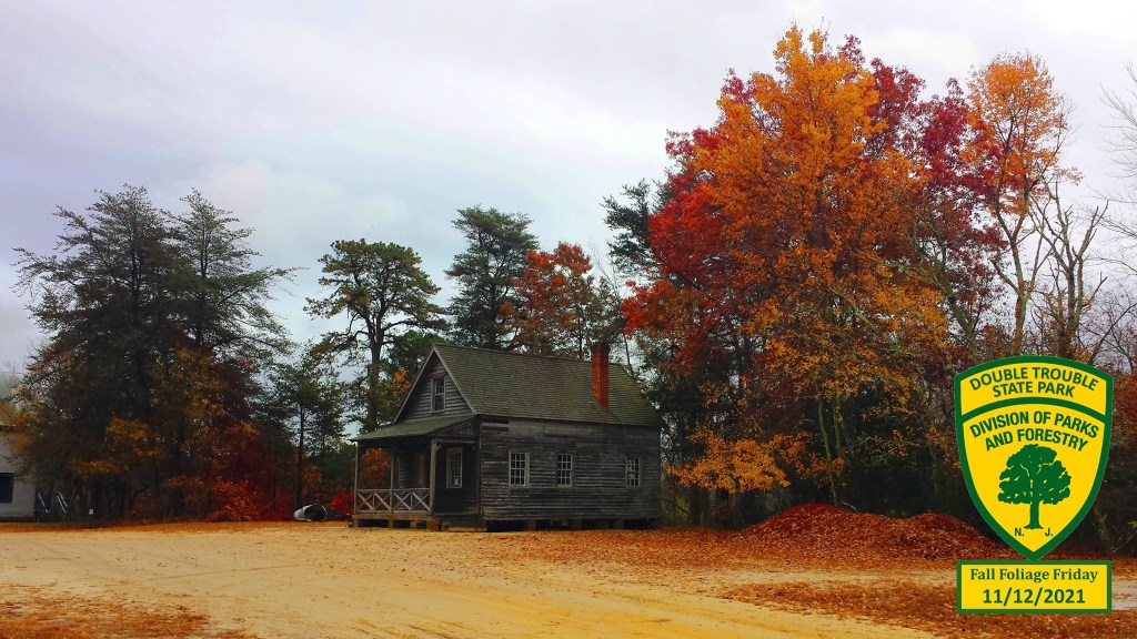
2021’s Fall Foliage at Double Trouble State Park (New Jersey Division of Parks and Forestry) How Double Trouble got its name is up for debate, but the leading theory is that the dam at the village had to be repaired twice in one week due to muskrats. When a townsperson said “here’s more trouble” to a local minister, the minister replied, “yes, double trouble.”
What ingredients are needed for perfect fall foliage?
From the time the first green leaves sprout on the branches, to when the last crinkly brown leaf falls to the ground, there are four distinct ingredients that will create the perfect fall foliage season.
1. From April to June, you want wetter-than-average weather. This gives the trees plenty of nutrients for growing foliage.
2. Then, during climatological summer, from June to August, you’re looking for no extremes – no extreme heat and no extreme cooldowns, either. If there are, the trees get stressed.
3. From the beginning of locals summer in September, to the time of peak leaf change, you’re looking for sunny days and cool nights to allow those vibrant fall hues to develop.
4. Once we reach peak foliage, you’re simply looking for no heavy precipitation or wind. This way, the leaves won’t get blown off the trees early. That gives you plenty of time to enjoy them.
When does fall foliage typically peak in NJ?
For most of inland New Jersey, the average peak of fall foliage season is the third to fourth week in October, according to the meteorologist-led ExploreFall.com. At the Jersey Shore, as well as lower Cape May County, it’s early November.
ExploreFall’s map archive shows that fall foliage tended to peak later in the 2010s than it did in the 1990s. However, New Jersey has returned to more typical timing in the 2020s, aside from last year, which was later than usual.
How was 2024’s fall foliage in NJ?
Zsoldos at the Forest Service said last year’s fall foliage was later than average. However, ExploreFall.com shows that it was within seasonable levels. The fall foliage season wound up being dull and quick to change. That was after a very promising April-to-August period, weather wise. Then the longest rain-free streak on record, and most significant drought in years put an end to the vibrant fall potential.
‘Average’ fall foliage season expected in NJ this year
On the vibrant side, there was plentiful rain during the spring to bring the trees the nutrients they need. According to the Office of the New Jersey State Climatologist, 13.17 inches of precipitation fell throughout New Jersey from April to June – climatological spring. The average is 11.75 inches. Moreover, the cooler-than-average weather, which has controlled New Jersey since the beginning of August, produced many cool nights.
“It’s going to help spark those indicators in trees to tell them it’s time to stop growing and start growing their sugars in the roots for winter (sugars help produce the vibrant colors),” Zsoldos said.
From July 1 to Sept. 12, Atlantic City International Airport had 24 days with a low temperature at or below 60 degrees, according to the Iowa Environmental Mesonet. That’s more than the average of 16 days. Near Double Trouble State Park at Lakehurst Naval Air Station, there have been 30 such days – the most on record.
On the other hand, New Jersey still hasn’t fully recovered from the drought which ran from last fall to early this year – the most significant on record. That put stress on the trees early in the growing season. There was also a stretch of extreme heat from June 23 to 25. Inland highs were in the 100s, with even the beaches getting well into the 90s.
“I think this year, we’re looking at an average fall foliage,” Zsoldos said.
During my visit with Zsoldos on Sept. 12, he noted the changes in the leaves already seen. He reminds us that fall foliage is a season and not a quick event. He usually sees the first orange and red hues on red maples in early August. You’ll still see a few, vibrant, straggling leaves during Thanksgiving, too.
As the leaves turn vibrant, we’ll still need heavy rain and fierce winds to stay away from New Jersey to fully enjoy them. Medium-range forecast models lean toward drier weather for October and November. That means fewer opportunities for the rain and wind that would rip the leaves off the trees. It’s good news for leaf peepers.
A widespread freeze also can quickly shut off the fall foliage process, turning green leaves to dull and brown colors quickly. While there’s always a risk of one night below 32 degrees between now and early November, when fall foliage usually peaks at the shore, there is no strong colder-than-average signal during this time.
Where are the great spots to view fall foliage in NJ?
“Average” is not a bad thing. An average fall foliage season will yield vibrant reds in the oak trees, yellows in the black maples and gold in the hickories across New Jersey, according to the United States Forest Service.
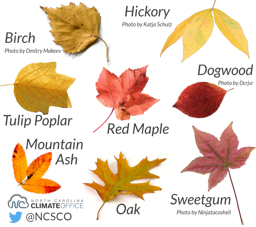
Types of Fall Foliage, by tree species (North Carolina Climate Office) At Double Trouble State Forest, you’ll find excellent walking trails to take in the fall hues. Wharton State Forest is also an excellent spot, allowing visitors to go back in time to historic Batsto Village, and the wide trails and scenic views along the Mullica River.
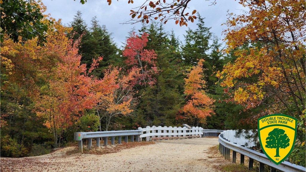
One of Double Trouble State Park’s many walking trails (New Jersey Division of Parks and Forestry) Birch Grove Park in Northfield is a personal favorite as well. It was home to my first Fall Foliage Forecast in 2017, and the walking trails built over the pond are an excellent way to spend the day.
Joe Martucci, a Certified Broadcast Meteorologist and Digital Meteorologist, is the President and Director of Meteorology for Cup A Joe Weather and Drone. You can connect with him at cupajoe.live/.