Hurricane Erin glanced the Jersey Shore with an indirect blow, causing historic summertime flooding, dangerous surf and beach erosion. It marks the beginning of the peak of hurricane season, which promises to be active in the Atlantic Hurricane Basin.
How will the rest of hurricane season be?
It will probably be more active than usual, with a typical risk to the Jersey Shore.
Colorado State University updated its forecast for August. For the hurricane season as a whole, from June to November, they project that 2025 will have 16 named storms. Of those, eight of them are expected to become hurricanes and three of them major hurricanes – Category 3, 4 or 5 storms.
On average, there are 14 named storms – seven hurricanes and three major hurricanes each year. This year is a bit more active than usual. As of Aug. 23, we’ve already had some storms in the Atlantic, so the forecast predicts 11 more named storms – seven hurricanes and two major hurricanes to come. There’s still a lot of energy left in the hurricane season and we hope it doesn’t hit New Jersey.
Colorado State University estimates the chances of a storm coming within 50 miles of New Jersey from Aug. 5 to Nov. 30 as follows:
25% chance of a named storm
8% chance of a hurricane
1% chance of a major hurricane
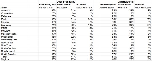
All of that is about the average for the state. While Hurricane Erin impacted the shore, the storm’s center was 450 miles away from New Jersey at its closest, so that didn’t count. The peak of hurricane season is here.
On average, the most active stretch of hurricane season is from mid-August to mid-October, peaking around Sept. 10, according to the National Hurricane Center in Miami, Fla. Not only are there the most storms during this time, but they’re typically the most intense. That’s due to the Atlantic Ocean, Caribbean Sea and Gulf of Mexico (Gulf of America) having their widest range of water temperatures: 80 degrees.
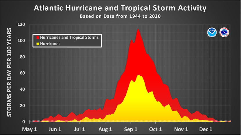
Furthermore, Cabo Verde (or Cape Verde) storms are more likely during this time. Like Hurricane Erin, these are the far traveling storms that roll off the West Coast of Africa and travel across the ocean, giving it ample time to strengthen and organize.
Key factors for the
rest of hurricane season
Colorado State University points to a few ingredients they’re paying attention to through November.
The first one is sea surface temperatures. The central and eastern parts of the Atlantic Ocean were well above average in July. However, they’ve trended toward seasonable recently.
The highest hurricane activity happens when the tropical Atlantic Ocean is more above average than the rest of the Atlantic Ocean. In other words, if the tropical Atlantic Ocean is 2 degrees above average, and the rest is 1 degree above average, that usually means more tropical cyclones. That’s not the case now given that Hurricane Erin cooled the water as it passed through the tropics, but this will be studied.
Also, hurricanes can be affected by something called El Niño, La Niña, or neutral conditions (sometimes called “La Nada” for fun). This year, we’re close to neutral or La Niña, which means a slightly more active hurricane season.
The last significant factor is the high amount of wind shear in the Caribbean Sea. Wind shear weakens hurricanes during hurricane season by disrupting their spinning structure, similar to how a strong gust might disrupt a spinning top, making it harder for the storm to stay strong or grow.
If that remains, the hurricanes will be torn apart and weaken if they try to move from Africa into the Caribbean Sea and then northwest into Mexico, Cuba or the United States Gulf Coast.
Wind shear in the Caribbean Sea doesn’t impact New Jersey much, though.
Key messages for N.J.
Hurricane Erin was a good reminder of what tropical systems can do to the coastline. Always listen to public safety officials during a weather emergency. They know how to keep you safe.
If they tell you to leave your area, do it right away. Closing beaches and businesses to evacuate is important, and only happens when it’s really dangerous. They ask you to leave because staying could be very risky.
Now is a good time to make your “Go Bag.” If you attended the Downbeach Community Meeting in Ventnor on Aug. 6, officials from Ventnor, Margate and Longport talked about this. Also, follow what we in the weather community are saying. Hurricanes.gov is the official resource for storm information.
If you follow me on my website or social media that’s great and I love that. However, any degreed meteorologist is trained to deal with these situations.

Look for those designated with a Certified Broadcast Meteorologist or Certified Digital Meteorologist seal from the American Meteorological Society for extra credibility.
Leave a Reply