THURSDAY’S FORECAST | My oh my. What an awesome day you’re in for with this Jersey Shore weather! We’ll keep the good times rolling through Sunday. After that, the remnants of Hurricane Isaias will run on through.
Jolt your brand with the Shore’s top weather media company. Advertise with Cup A Joe Weather today! advertise@cupajoe.live.
The late September 2026 nor’easter brought the Jersey Shore a problem that lasted far beyond one high tide: flooding that returned again and again, while rough surf wore away beaches.
On Tidal Flooding Talk, brought to you by the New Jersey Coastal Coalition, Joe Martucci, Palma Shiles and Dan Skeldon explained why the water stayed high, what homeowners can learn and how misleading storm videos complicate public warnings.
Six days of returning floodwater
According to Martucci’s episode recap, southern Barnegat Bay experienced 12 consecutive high tides with flooding — roughly six straight days. The Ocean City area had 10, while much of the remaining shore experienced six to eight.
The storm’s slow movement helped keep water pushed toward the coast. Skeldon explained that winds blowing from the ocean toward land had already raised water levels before the storm developed. The storm then strengthened that pattern.
That meant each incoming tide arrived before conditions had fully recovered.
Rain added another problem in parts of Monmouth County. Martucci explained that high coastal water levels limited drainage, while heavy rain added water to already flooded areas. Together, those conditions made flooding worse.
The lesson: coastal flooding depends on more than rainfall. Wind direction, storm movement and repeated high tides all matter.
Why a few inches matter
Shiles said the storm showed the value of lifting air conditioners and other mechanical equipment above floodwater.
“It’s not always just a hurricane that brings major flooding,” she said.
September also created a preparation challenge. Some seasonal residents had already left, while outdoor furniture and other summer items remained unsecured.
Drivers added another concern. Vehicles traveling through flooded streets create waves, or wakes, that can push water toward nearby homes.
“For someone that wasn’t gonna flood on their first floor, now you just pushed all that water right to their door,” Shiles said.
A vehicle’s ability to get through a flooded street does not mean the trip is harmless to neighbors.
The damage outlasts the flooding
Skeldon pointed to beach erosion as a lasting impact. Days of pounding surf removed sand before the main nor’easter season.
Martucci also explained why sand lost from a replenished beach does not automatically mean the project failed. That sand provides a buffer between waves and the community behind it. Evaluating its value means considering what the storm might have reached without that protection.
Check before you share
The hosts closed with another storm hazard: misleading images and videos.
Shiles urged viewers to check the source and the date and time of a post. Martucci encouraged people to judge weather sources by the accuracy of their information.
“Judge me based on the information we’re providing,” he said.
The episode’s takeaway is practical: prepare for repeated tides, keep vehicles out of floodwater, and verify storm posts before sharing them.
😎WEDNESDAY’S FORECAST | Octobrrrr is in full swing! We’re starting in the mid-30s. Temperatures rebound though. I even spy a good beach day Thursday! The remnants of Tropical Storm Isaias WILL swing through NJ over part of the holiday weekend
For the latest and greatest interviews with artists, authors and entrepreneurs—as well as thoughtfully curated lists of favorites that are never bought and paid for–visit jennypennywriting.com!
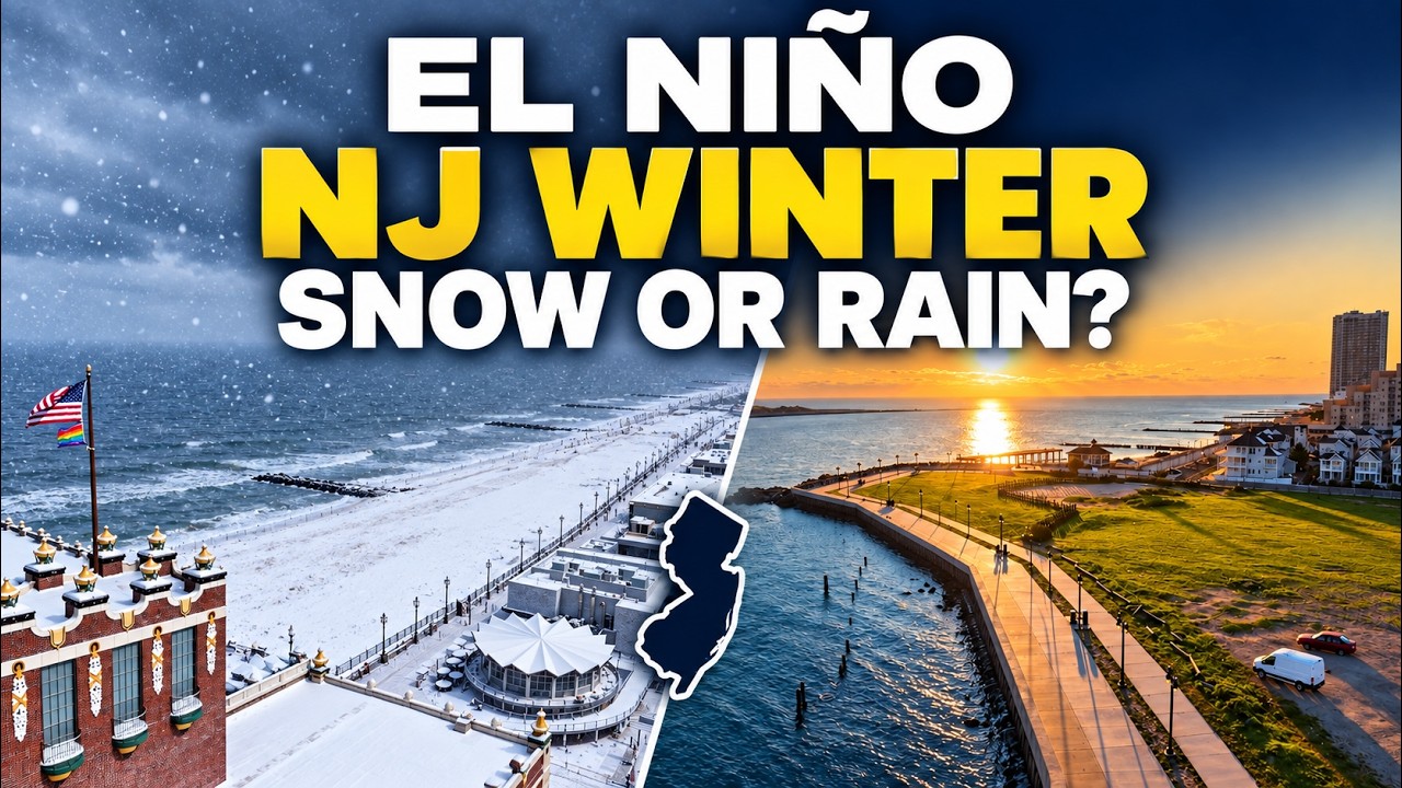
A strong El Niño will shape New Jersey’s winter, but that doesn’t give us a simple answer about snow.
I spoke with Dr. John Krasting, New Jersey State Climatologist, about what this Pacific Ocean weather pattern could mean for the Jersey Shore.
El Niño happens when water in the tropical Pacific stays warmer than usual. That warmth can change the jet stream, the fast-moving air that helps steer storms.
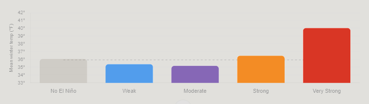
During El Niño winters, a stronger southern jet stream can bring more rain and coastal storms toward New Jersey. However, every El Niño is different. Some winters have been warm and fairly dry, with one major snowstorm standing out.
My research on very strong El Niño events points toward milder winters at the Jersey Shore. That could favor rain over snow during many storms.
Still, a mild winter can deliver a big snowfall. We would need cold air and the right storm track to come together.
High pressure to our north could also slow storms down. That makes coastal flooding another concern to watch as winter approaches.
TUESDAY’S FORECAST | The next time rain is in the forecast is Sunday, if not Monday! We could use the break. Temperatures bounce between sweater weather and Locals’ summer. That includes one day where frost is possible.
Jolt your brand with the Shore’s top weather media company. Advertise with Cup A Joe Weather today! advertise@cupajoe.live.
😎MONDAY’S FORECAST | Who’s ready for sun and beautiful Autumn weather?! Well, I’ve got GREAT news for you! Just make sure you’re prepared for some 40s in the morning.
Sparkable is a boutique SEO and digital marketing agency in Atlantic City. When Shore customers search for what you do, we make sure they find you. Free site check at sparkable.com/shore
September gave New Jersey a warm start, a welcome break from drought and a coastal storm that kept coming back for more.
In our monthly weather roundup, I joined Dr. John Krasting, New Jersey State Climatologist, to unpack a month that went from beach weather to flooded streets. We also looked at what a powerful El Niño could mean for the months ahead.
A nor’easter that wouldn’t quit
The September nor’easter’s biggest story wasn’t just how high the water rose. It was how long the flooding lasted.
Dr. Krasting reported 12 high tide cycles with at least minor flooding at Atlantic City and Cape May during the September 22–30 period. Those were flooding tides across that stretch, rather than 12 straight flooded high tides.
He said that kind of repeated flooding hadn’t been seen there since the December 1992 nor’easter.
I saw the impacts firsthand in Highlands on Saturday morning. In the lower part of town, floodwater reached several blocks inland. Water spilled over the bulkhead and rose above my knee-high boots.
Strong winds pushed water toward shore for days. High tides and heavy rain added to the trouble. Dr. Krasting explained that when several sources of flooding overlap, the impacts become harder to measure and compare.
The wind was fierce, too. Surf City recorded a peak gust of 74 mph, while Harvey Cedars reached 69 mph.
Although the storm’s turn toward New Jersey brought comparisons to Sandy, Dr. Krasting stressed that Sandy was a much larger storm. Similar tracks do not mean similar impacts.
Rain brought some good news
September’s rain also helped ease New Jersey’s long drought.
Preliminary statewide rainfall totaled 6.16 inches, about two inches above normal. If those numbers hold, September would rank as the state’s 17th wettest.
It also marked the third straight month with above-average rainfall.
Dr. Krasting reported that New Jersey had left drought status on the U.S. Drought Monitor, though some areas remained abnormally dry. The state’s drought warning had also been lifted.
Still, water underground remained low in parts of the coastal region. Recovery takes time, even after several wet months.
Warm nights stood out
September’s preliminary statewide average temperature was 68.2 degrees, about 1.3 degrees above normal.
The warm nights were especially notable. Some locations stayed in the mid-70s overnight early in the month. Before the nor’easter arrived, much of September offered the warm weather many Shore residents call “local summer.”
What about winter?
Our discussion also covered a strong El Niño, a pattern involving unusually warm water in the tropical Pacific.
Dr. Krasting explained that it can strengthen a major storm track, potentially bringing more coastal storms and precipitation.
That does not guarantee a snowy winter. Temperatures and the timing of cold air still matter.
After September’s repeated flooding, the question heading into winter is whether future storms will bring those same ingredients together again.
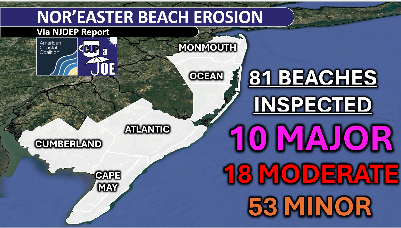
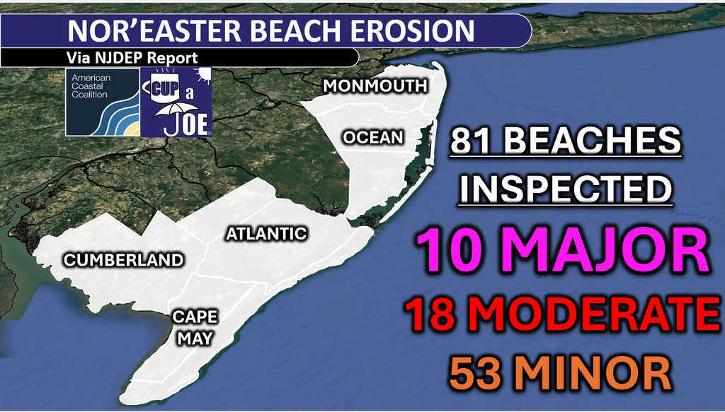
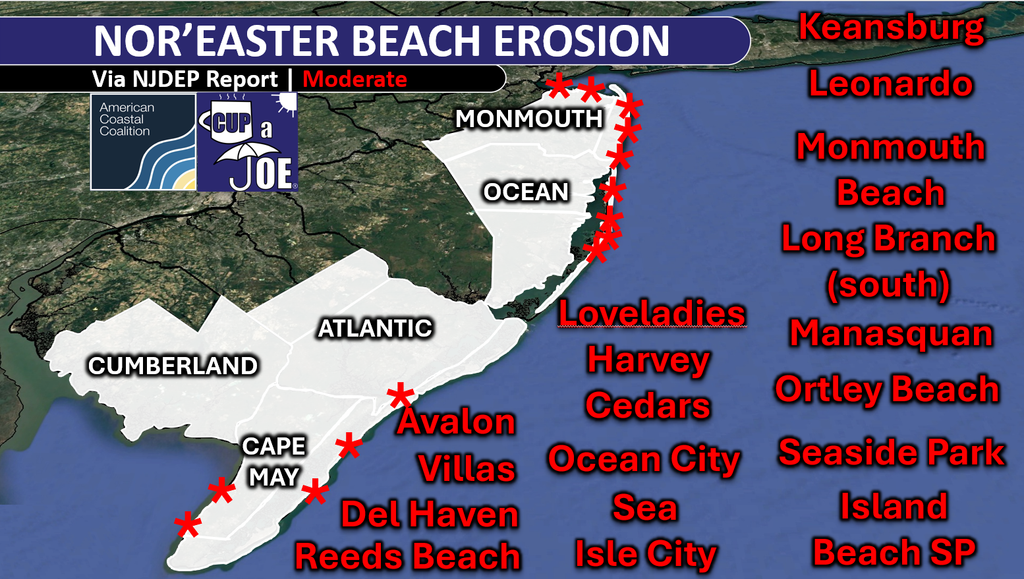
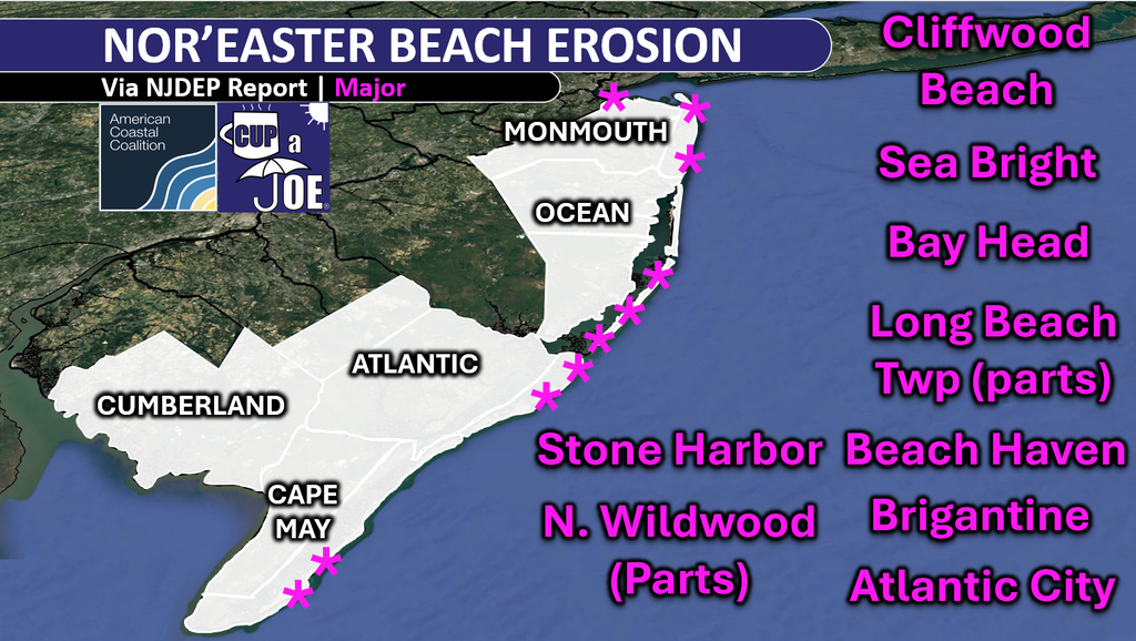
The NJDEP went to every beach in NJ and here’s what they found.
10 beaches with major erosion, 18 beaches with moderate erosion, 53 beaches with minor erosion.
Honestly, I thought it’d be worse. The multiple high tides with over 3 feet of storm surge can create major scarping (cliffs of sand) quickly. Cumberland County fared the best. This wasn’t a Delaware Bay storm this time.
Still, it was significant, and early. Keep in mind that nor’easter season doesn’t traditionally begin until Mid-October. With a very strong to record El Nino, more of this is certainly possible.
The nor’easter brought up to 12 consecutive tides with tidal flooding, and beach erosion, to the Jersey Shore. Nearly every station that faces that Atlantic Ocean had six consecutive high tides with flooding.
Furthermore, tides gauges had one of their highest tides on record that Saturday morning (9/26). That included Atlantic City, where the 12th highest tide since 1911. That’s the 12th highest out of over 80,000 high tides.
Strong winds Friday night and Sunday morning also helped to erode beaches. Gusts topped 60 mph in Avalon (Cape May County), Ship Bottom (67 mph), Harvey Cedars (69 mph), Island Beach State Park (70 mph) and Surf City (74 mph).
Come visit Headley Family Farm at 120 Province Road in West Creek! It’s where farming the pines meets the Jersey Shore. Get your Jersey Fresh produce here. Open weekends and some weekdays. Call us at 609-848-3763 or follow on Facebook, too!
It’s a blackout beauty. Let’s shock the world. Go RU .
🏈 Your Rutgers tailgate headquarters! Parking at St. George is only 500 yards from SHI Stadium and features 500+ spots, clean restrooms, and quick access to River Road. It’s where Joe parks! Purchase at: www.rutgersparking.com.