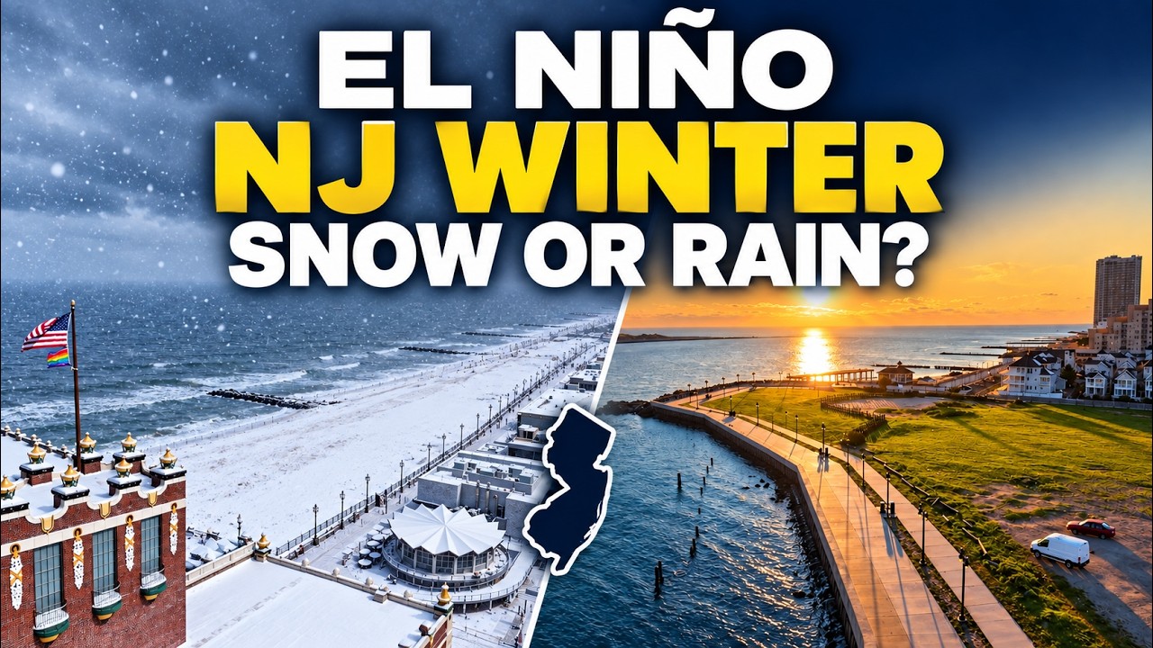
A strong El Niño will shape New Jersey’s winter, but that doesn’t give us a simple answer about snow.
I spoke with Dr. John Krasting, New Jersey State Climatologist, about what this Pacific Ocean weather pattern could mean for the Jersey Shore.
El Niño happens when water in the tropical Pacific stays warmer than usual. That warmth can change the jet stream, the fast-moving air that helps steer storms.
During El Niño winters, a stronger southern jet stream can bring more rain and coastal storms toward New Jersey. However, every El Niño is different. Some winters have been warm and fairly dry, with one major snowstorm standing out.
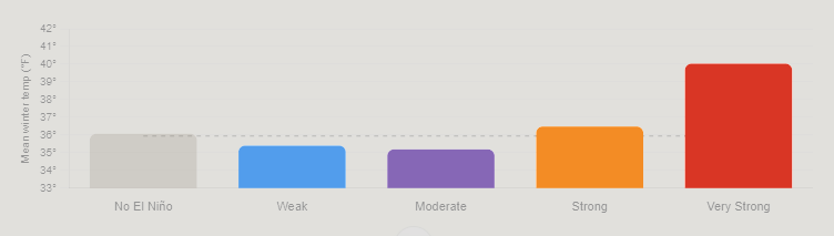
My research on very strong El Niño events points toward milder winters at the Jersey Shore. That could favor rain over snow during many storms.
Still, a mild winter can deliver a big snowfall. We would need cold air and the right storm track to come together.
High pressure to our north could also slow storms down. That makes coastal flooding another concern to watch as winter approaches.
September gave New Jersey a warm start, a welcome break from drought and a coastal storm that kept coming back for more.
In our monthly weather roundup, I joined Dr. John Krasting, New Jersey State Climatologist, to unpack a month that went from beach weather to flooded streets. We also looked at what a powerful El Niño could mean for the months ahead.
A nor’easter that wouldn’t quit
The September nor’easter’s biggest story wasn’t just how high the water rose. It was how long the flooding lasted.
Dr. Krasting reported 12 high tide cycles with at least minor flooding at Atlantic City and Cape May during the September 22–30 period. Those were flooding tides across that stretch, rather than 12 straight flooded high tides.
He said that kind of repeated flooding hadn’t been seen there since the December 1992 nor’easter.
I saw the impacts firsthand in Highlands on Saturday morning. In the lower part of town, floodwater reached several blocks inland. Water spilled over the bulkhead and rose above my knee-high boots.
Strong winds pushed water toward shore for days. High tides and heavy rain added to the trouble. Dr. Krasting explained that when several sources of flooding overlap, the impacts become harder to measure and compare.
The wind was fierce, too. Surf City recorded a peak gust of 74 mph, while Harvey Cedars reached 69 mph.
Although the storm’s turn toward New Jersey brought comparisons to Sandy, Dr. Krasting stressed that Sandy was a much larger storm. Similar tracks do not mean similar impacts.
Rain brought some good news
September’s rain also helped ease New Jersey’s long drought.
Preliminary statewide rainfall totaled 6.16 inches, about two inches above normal. If those numbers hold, September would rank as the state’s 17th wettest.
It also marked the third straight month with above-average rainfall.
Dr. Krasting reported that New Jersey had left drought status on the U.S. Drought Monitor, though some areas remained abnormally dry. The state’s drought warning had also been lifted.
Still, water underground remained low in parts of the coastal region. Recovery takes time, even after several wet months.
Warm nights stood out
September’s preliminary statewide average temperature was 68.2 degrees, about 1.3 degrees above normal.
The warm nights were especially notable. Some locations stayed in the mid-70s overnight early in the month. Before the nor’easter arrived, much of September offered the warm weather many Shore residents call “local summer.”
What about winter?
Our discussion also covered a strong El Niño, a pattern involving unusually warm water in the tropical Pacific.
Dr. Krasting explained that it can strengthen a major storm track, potentially bringing more coastal storms and precipitation.
That does not guarantee a snowy winter. Temperatures and the timing of cold air still matter.
After September’s repeated flooding, the question heading into winter is whether future storms will bring those same ingredients together again.
😎TUESDAY’S FORECAST | For the first time in NINE weeks, we have a dry workweek. Some think that means a boring weather video, but not here at the Jersey Shore. There are a few exciting things to talk about!
Tired of water in your basement or crawlspace? Trust Finally Dry Waterproofing family-owned company to fix it right. We install permanent drainage solutions guaranteed for 2 ownerships with no limit! Get your FREE inspection at finallydrywaterproofing.net .
The Jersey Shore is entering its driest stretch of the year. At Atlantic City International Airport, the driest 30-day period runs from August 23 through September 21, with rain falling on roughly one in four days.
The chance drops to just 14% on September 5. Long Branch’s driest stretch runs from August 16 through September 14.
Weaker cold fronts, fewer thunderstorms and a jet stream positioned north of New Jersey limit rainfall. Nor’easter season has not started, leaving tropical systems as the region’s primary rain source.
I start my weekday mornings with Monmouth365 for my Monmouth County weather (from us!), local news, events, business updates, and positive stories from across the community. 📰 Subscribe free: www.monmouth365.beehiiv.com/subscribe?ref=5lTZKBW9hL
TUESDAY’S FORECAST | We’ve entered our driest time of the year, on average. So will Mother Nature cooperate at the Jersey Shore? Mostly.
Tired of water in your basement or crawlspace? TrustFinally Dry Waterproofingg’s family-owned company to fix it right. We install permanent drainage solutions guaranteed for 2 ownerships with no limit! Get your FREE inspection at finallydrywaterproofing.net .
On June 30, 2026 Dave Robinson, the New Jersey State Climatologist since 1991 and Distinguished Professor at Rutgers University, retired.
Dave Robinson is my birthday buddy (May 13th), research advisor (2013), Monthly Weather Roundup co-host, weather dad and friend.
He is New Jersey climate. In the science world, knowing your stuff and communicating that stuff doesn’t always go hand in hand. He mastered both. He’d just ask quickly do a Zoom call for an interview as he would spit off a list of the top 10 most humid years in New Jersey’s history.
“What I find incredibly inspiring about Dave is that he really was the essence of the office for several decades,” John Krasting, the incoming state climatologist said. “I’m going to be inheriting a wonderful program that has developed over the years into one of the leading state climate offices in the nation.”
From left to right: Joe Martucci, Shawnie Martucci, Dr. Missy Holtzer, Dr. Dave Robinson, Christina Marguccio and Nick Marguccio during Dave’s retirement symposium in April 2026 at Rutgers University.
My journey with Dr. Robinson began in 2013, during my last semester at Rutgers, when I wanted to do research for credit. The topic was dew point climatology, looking at moisture in the air across different parts of New Jersey.
That report is still somewhere at the State Climate Office, or maybe at Dave’s home. Either way, it became a valuable learning experience. It also gave me the chance to meet Mat Gerbush, the assistant state climatologist, and a young Dan Zarrow, now Chief Meteorologist for NJ 101.5 and Townsquare New Jersey.
After I graduated, it would be six years before Dave and I connected again.
We were both at the New Jersey Emergency Preparedness Association conference in Atlantic City. He was there to give a talk. I was there to cover it as the new meteorologist for The Press of Atlantic City.
For months, I had wanted to talk with him about New Jersey weather and climate. He had long been such a positive, trusted voice for science in the state. Still, I was nervous. We hadn’t talked in years. Would he remember me?
I’m pretty sure he did.
I walked up to him, we made small talk, and he asked about my career. Then I asked if he would be interested in doing a podcast episode with me for The Press. The show was called Something in the Air, and the idea was to look back at the previous month’s weather and place it in the larger context of climate.
He said yes.
The issue was figuring out how to do it remotely. He was in Piscataway. I was in Galloway. It was 2019: pre-COVID, pre-work-from-home, pre-remote-everything.
We ended up using Stockton University’s TV program, where The Press produced its newsmagazine show, -30-. The first couple of episodes were shaky, but they worked. I can’t find video from those early days.
Then COVID happened.
No more TV studio. Instead, I used a new program called Zoom to interview him. No virtual backgrounds, no polished setup. Just my apartment and his kitchen.
It worked, but it a far cry from today.
There were many early struggles then, mainly my fault. I couldn’t get my external mic to work on Zoom. We’d have weird black spots on the video from the video boxes being the wrong space. I think one time I forgot to hit record. Still, he kept recording with me giving grace (perhaps having the same birthday helped).
Eventually, the Something in the Air podcast turned into the Monthly Weather Roundup. We did it almost every month for years! Two of them, my other weather dad, Jim Eberwine, filled in.
The longest break was after Lee Enterprises laid me off in June 2024. I took the summer off to regroup and when I started Cup A Joe Weather and Drone, the Monthly Weather Roundup came back in October 2024.
The publicity of the episode has only grown since then. We’re back into audio podcasts, we create vertical videos from the episodes and break out parts of the show. Subtitles were added earlier in 2026 to increase your experience. All was good.
When Dave told me he was retiring, I was happy for him. He loved his work. The days (and nights) were long. He has his kids, wife and most importantly, his grandkids. He loves to travel and now he could go during the semester!
Even he doesn’t know how he’ll go from 60 hour work weeks to retirement. A Yankees game the day after his retirement and trip to Europe following that will help a bit. The reality will probably settle in later this summer. He’s also moving on from the Rutgers Global Snow Lab, which he ran for years.
I hope you all enjoyed this iteration of the Monthly Weather Roundup. We documented every month of New Jersey weather for the past 7 years, giving important context that a brief sound bite or quote in an article can’t do.
“People have some level of knowledge, but they often do not appreciate the full impact weather and climate have on every aspect of society. It affects transportation, the economy, tourism, emergency management, agriculture, the environment and daily life,” Robinson said.
Now, I hope his daily life is full of snow for cross-country skiing, sunshine for his biking and time with his family.
The Drought Situation: An Overview
The month of June has brought alarming news regarding drought conditions across New Jersey. As of the end of June, areas stretching from Long Beach Island down to Cape May County are experiencing extreme drought (D3), while much of the state is under severe (D2) and moderate drought (D1) categories. Farmers, like those from Headley Family Farm in Eagleswood, are feeling the impact as irrigation systems struggle to maintain crops amidst low surface water and minimal precipitation.
The next drought monitor report, set to be released on July 2nd, will provide an update on these conditions. Interestingly, while the highlands have seen some recovery with recent rains, the coastal areas remain critically dry. This disparity highlights the need for targeted rainfall to alleviate stress on water resources.
Historical Context: Precipitation Deficits
June’s precipitation levels reflect a troubling trend, with New Jersey averaging below-normal rainfall for the month. This marks the twenty-third out of the last twenty-six months with below-average precipitation, a situation not seen since the mid-1960s. Dr. Robinson notes that this persistent drought is characterized more by its longevity than by extreme dry spells. In the past two years, New Jersey has seen consistent deficits, with precipitation often falling to about 75% of normal levels.
The coastal counties have been particularly hard hit, receiving only a fraction of the expected rainfall. For instance, Cape May recorded just over two inches for June, compared to the average of nearly four inches. This ongoing drought not only threatens crops but also raises concerns about water availability for residents and wildlife.
The Transition of Dr. Dave Robinson
As we reflect on the month’s weather, it’s also a moment to acknowledge Dr. Dave Robinson, who has been New Jersey’s state climatologist since 1991 (which as long as Joe Martucci’s been alive). As he prepares for retirement, he shares his mixed feelings about leaving a position he has held with pride. Robinson emphasizes the importance of proper timing in transitioning from a career, noting that he looks forward to spending more time with family and pursuing personal interests, including his writing projects.
Dr. Robinson also highlights the importance of understanding climate patterns and their implications for agriculture and water resources in New Jersey. His insights serve as a reminder of the impact weather and climate have on our daily lives and the necessity for ongoing monitoring and research.
Looking Ahead: What’s Next for New Jersey Weather?
With the hot summer months ahead, the potential for heatwaves raises further concerns about drought conditions. New Jersey typically experiences its wettest month in July, but the current forecasts suggest that the areas most in need of rain may continue to face challenges. Robinson urges residents to be proactive in water conservation and to stay informed about local restrictions.
As we move into July, the call for rain is more urgent than ever. The combination of high temperatures and low humidity could exacerbate the already dry conditions, leading to increased fire risks during holiday celebrations like Independence Day. Residents should be mindful of fire safety and follow local guidelines to protect their communities.
Conclusion
June has been a month of mixed emotions and pressing challenges for New Jersey. As we bid farewell to Dr. Robinson, we also prepare for the ongoing struggle against drought. Understanding these weather patterns is crucial for adapting to future climate challenges. For now, we hope for a shift in the weather that brings much-needed rain to our parched state.
Frequently Asked Questions
What is the current drought status in New Jersey? As of late June, New Jersey is facing severe drought conditions, particularly in coastal areas.
How does the drought impact local farmers? Farmers are struggling with low surface water and are relying heavily on irrigation to sustain their crops.
Why is Dr. Dave Robinson stepping down? Dr. Robinson is retiring to spend more time with family and pursue personal projects.
Weather Forecasts That Last Way Longer Than We Thought Possible
Scientists have long believed that weather forecasts can only be really accurate for about two weeks. After that, tiny mistakes in the starting weather data grow so fast because of chaos (the “butterfly effect”) that the forecast becomes useless. A new study challenges that old rule using an AI weather model.
What They Did
Researchers took a popular AI weather model called GraphCast. This model is special because it can “learn” from data and also figure out how small changes in the starting weather affect the forecast days later.
They didn’t just run normal forecasts. Instead, they tweaked the starting weather picture (called the initial conditions) for every day in 2020 — over 700 forecasts in total. They used math to find the best possible starting point that would make the forecast match what actually happened as closely as possible. They did this step by step, starting with short forecasts and slowly making them longer.
They tested this on a big computer using two levels of precision (like using more decimal places for more accuracy).
What They Found
The results were surprising:At 10 days ahead, the tweaked forecasts had 86% less error than normal forecasts that started from regular weather data. Every single forecast got better — none failed.
The forecasts stayed useful much longer. The weather patterns matched reality well out to about 27–28 days, and some skill lasted past 30 days. The errors grew at a steady rate, but started from a much better place, so they stayed smaller for longer.
They also checked if the AI was just making smoother, less detailed forecasts (which would look better but be less useful). It wasn’t — the improved forecasts kept the right amount of detail and activity.
What the “Tweaks” Looked Like
The changes they made to the starting weather weren’t random or tiny. On average, they showed a clear pattern:They made the big tropical air loop (warm air rising near the equator and sinking farther north and south) stronger than in the normal weather data.
This included:
Making some ocean areas near the tropics a bit cooler or warmer in the right places Adding or removing moisture in patterns that matched real weather systems Changing how air rises and sinks over large areas
These changes were about the same size as normal small errors in weather data. They weren’t crazy or unrealistic.
Testing in a Different AI Model
To make sure this wasn’t just a trick that worked only in one AI model, they took the improved starting points and used them in another AI model called Pangu-Weather.
The other model also got better forecasts — about 21% less error at its best point (around day 4). It wasn’t as big an improvement as in the first model, but it was still clearly better than normal. This shows the better starting points helped in general, but some of the improvement was specific to the first model.
Why This Matters
This study shows that better starting weather data can push accurate forecasts well past the old two-week limit — at least for big weather patterns across the whole planet. It suggests the atmosphere might be more predictable at large scales than we used to think, and that current weather data has some fixable mistakes in big patterns like the tropical air loop.
Important limits
The scientists knew what the weather actually did later (they were looking backward). This isn’t yet possible in real-time forecasts.
It works best for big, continent-sized weather features, not tiny storms or local details.
It took a lot of computer power for each forecast.
Bottom Line
The old idea that weather becomes unpredictable after about two weeks may not be as strict as we thought — at least when we use smart AI tools to find better starting points. This doesn’t mean we’ll have perfect 30-day forecasts tomorrow, but it opens the door to much longer useful forecasts in the future if scientists can figure out how to find these better starting points in real time.
The study is careful and well-tested. It doesn’t claim the atmosphere has no limits — it just shows those limits might be farther out than we believed when we start with smarter data.
Extreme (level 3/4) drought returned to NJ in Cape May and southern Cumberland counties, according to June 11th’s update from the United States Drought Monitor. It’s now the worst statewide drought since March 2025. However, with it being summer, and water usage at its peak for the year, mandatory water restrictions are closer than ever.
Nancy Adler Nutrition has practiced nutrition weight loss, naturally, for 30 years . Listen every Saturday to Nancy Adler Nutrition Live Saturday 11AM-1PM on WOND radio. Ready to lose the weight? Call Nancy at 609-653-4900.
For such a small state, NJ has BIG differences in temperatures sometimes. We went from low 40s in the Pine Barrens to the low 60s near NYC! Why? High pressure, clear sky and calm wind. Let’s look at the microclimates.
Sparkable is your full-service marketing department for your brand. From SEO to social media to website development, we deliver innovative strategies to elevate your digital presence. Let Sparkable ignite your brand’s potential. sparkable.com
WEDNESDAY’S FORECAST | Honestly, this could be our hottest 2 day stretch of 2026 and it’s only Mid-May! 100F for some again today. 60F by Friday. It’s like fire and ice!
Memorial Day weekend? 1 washout but it’s pretty dry otherwise.
Jolt your brand with the Shore’s top weather media company. Advertise today! joe@cupajoe.live