📹WEDNESDAY’S FORECAST | Break out the shorts, break out the flip flops, it’s our warmest day in weeks at the Jersey Shore!
(OK, it’s not that warm but it’ll feel nice out).
If your personal forecast feels uncertain this winter, support is available. See You Through It Counseling offers in-person and virtual therapy for children, adults, and couples. Invest in healing that lasts. Visit seeyouthroughitcounseling.com or call 856-335-1352.
With temperatures much colder than average around here, the depths of winter have been feeling more like New England than the Jersey Shore.
From Jan. 18 to 31, temperatures at Atlantic City International Airport were what the same typical two-week period would be in Portland, Maine, according to the Southeast Regional Climate Center. From Jan. 25 to 31, the mean temperature at Atlantic City International Airport was just 18.6 degrees. You’d have to travel far north to find similar readings. Anchorage, Alaska, is the closest match. The same is true at the Sen. Frank S. Farley State Marina.
Days of sub-freezing temperatures and nights with sub-zero windchills are certainly bitterly cold. However, you don’t have to look that far back to find Januarys just like it.
Believe it or not, January 2026 was milder than last January at both the airport and the marina, according to the National Oceanic and Atmospheric Administration (NOAA).
At Atlantic City International Airport, the average temperature for January was 30.8 in 2026, compared to 30.6 during the same period in 2025. Both readings fall a little below the mean of 33.0. At the Atlantic City Marina, the average was 32.7 in 2026, up from 32.1 in 2025, but still below the 34.5 mean. Even up the Jersey Shore at Long Branch, Monmouth County, 2025’s January was just 0.7 degrees milder.
In other words, January 2025 was colder. However, I hear you, 2026 just felt more frigid.
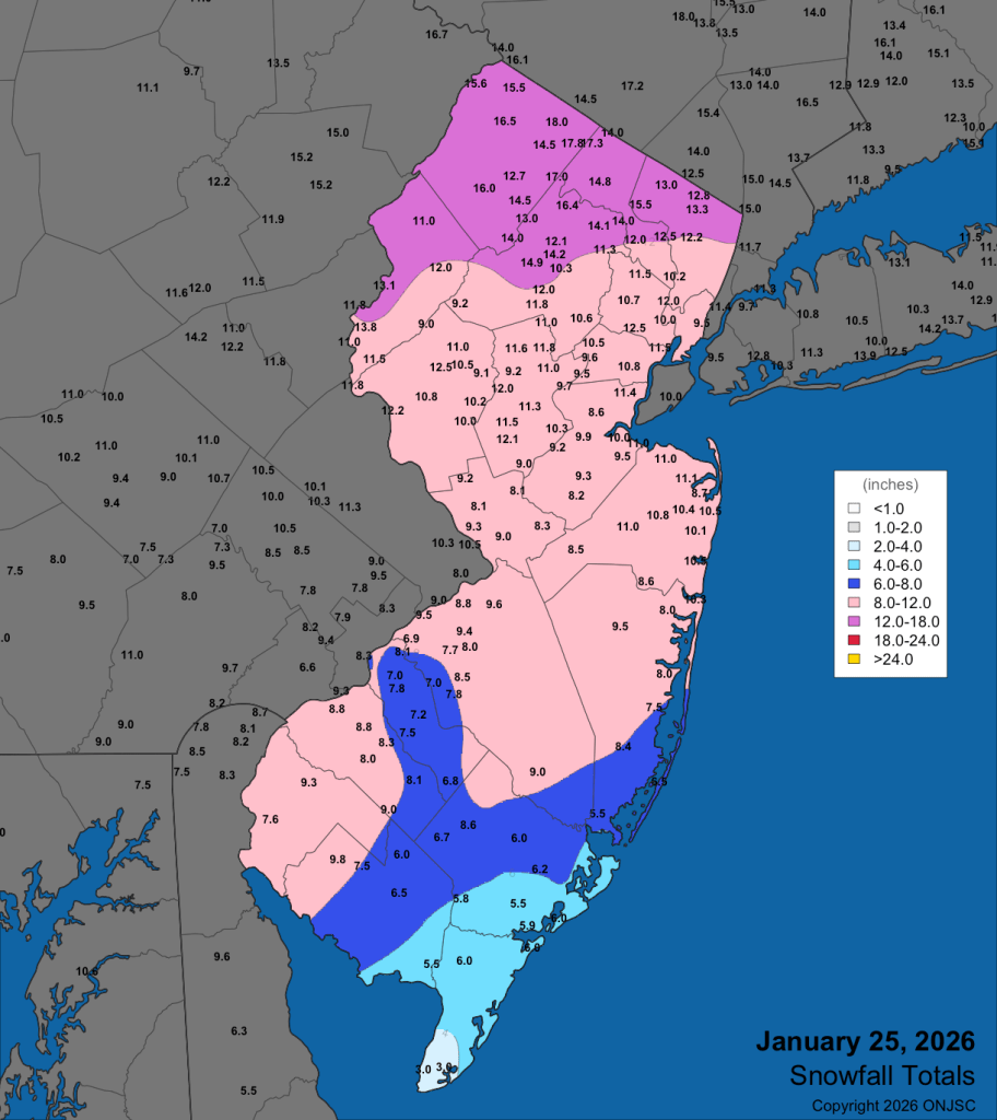
Maybe it’s because of the snow. Last January experienced a South Jersey Snow Special on Jan. 6. Six to 10 inches of snow fell in Lower Cape May County, with a plowable snow south of the Atlantic City Expressway. However, it was gone a week later. Meanwhile, our winter smorgasbord from Jan. 25 to 26 continues to be an icy glacier more than 10 days later.
A snow covered Mid-Atlantic from Feb. 2, 2026 on the visible satellite image. Note the green area in eastern New Jersey. That’s the dense forest of the Pine Barrens. There was still snow on the ground there. (College of DuPage)Snow and sleet totals from the Jan. 25, 2026 Winter Storm (Office of the New Jersey State Climatologist)
Maybe it’s because, compared to average, New Jersey is among the coldest places in the United States this winter, according to Ben Noll of the Washington Post.
Maybe it’s because our coldest days were colder. Five days were 15 or more degrees below average at ACY Airport this year. Last year, there were three. It was nearly the same in Atlantic City.
Otherwise, maybe it’s just because we remember only what happened to us lately. Last January had more days with gusts over 45 mph, according to NOAA, compared to this January.
Bay ice concentration in the Mid-Atlantic last January, at its peak (48.72%), was double what it was at its peak this January on Jan. 29 (20.5%).
Compared to the rest of recorded history, this January was just a little colder than average. In our climate-changing world, it’s been harder to achieve long stretches of bitterly cold temperatures.
Last month, the only cold temperature records that occurred within our four, long-standing Jersey Shore weather stations (Lower Township, Atlantic City International Airport, Atlantic City Marina and Long Branch) were:
Atlantic City Marina tied a record cold maximum temperature of 22 degrees on Jan. 30. Long Branch broke the cold maximum temperature record with 18 degrees on Jan. 31.
That’s not much. New Jersey had the 39th coldest January of 132 years of record keeping, Dave Robinson, the New Jersey state climatologist said on my Monthly Weather Roundup show. The coastal zone, which is generally anywhere east of the Garden State Parkway, was the 41st coldest.
December and January are as cold as the 1960s at Atlantic City Marina. ACY Airport was like an average one in the 1980s.
The climate is changing at a rate not seen since the end of the Paleozoic period 250 million years ago, according to research reported in Science magazine.
Looking ahead, February looks like it will be a colder-than-average month. That would be our first meteorological winter (December-February) colder than the long-term average in quite some time. However, if you’re done with the cold, keep in mind that the days are getting longer and it’s a little light past 6 p.m. now.
The more bitterly cold time of the year is behind us. Warmer days are on the way.
The Monthly Weather Roundup focused on January’s weather patterns, particularly the significant snowstorm and persistent cold.
Dave Robinson, New Jersey State Climatologist, discussed the January 25th storm, which brought snow, sleet, and freezing rain across the state, with snowfall totals ranging from 8 to 12 inches in Monmouth County.
He noted that while the storm was impactful, it could have been more severe if not for the cold air that limited snow accumulation.
The cold weather dominated the latter part of January, with Dave explaining that while it was cold enough for ice skating and cross-country skiing, it wasn’t record-breaking.
He emphasized that despite the recent cold spell, New Jersey has been warming over time, with the coldest days becoming less extreme.
The discussion also covered the state’s ongoing drought conditions, with January precipitation being below normal, and the impact of snow and ice on water availability.
Recap the month of weather that was. It’s all Jersey, with two of Jersey’s best weather guys. New Jersey State Climatologist Dr. Dave Robinson as well as Meteorologist Joe Martucci, owner of Cup A Joe Weather and Drone take you through the temperatures, rain, snow, coastal flooding and much more.
New episodes come out around the beginning of every month.
The Monthly Weather Roundup is sponsored by Jennifer Ansbach Coaching — helping students and adult learners Write. Revise. Rise. Learn more at JenniferAnsbach.com.
Also absent is yearly warmth. For the first time since 2014, the Jersey Shore will fall outside of the top 20 for hottest years since reliable records began in 1895, according to Dave Robinson, the New Jersey State Climatologist, while also my “weather dad” and May 13 birthday buddy.
However, a stretch of extremely hot days did make the top 10, so did muggy weather, severe weather, frigid weather, nor’easters, tropical systems, among other things.
Note that the data below is from the National Oceanic and Atmospheric Administration, unless written otherwise.
Let’s get into it.
10) Fortescue’s stifling high dew point on July 25
Fortescue juts out into the Delaware Bay in Cumberland County, allowing the sometimes very warm water to come onto the marshy land. Bay waters in the 80s paired with a very sultry wind from the Deep South brought the dew point to an astounding 88 degrees at 4 and 5 p.m. that day. That makes for extremely uncomfortable heat indices:
2 p.m.: 106 degrees
3 p.m.: 112 degrees
4 p.m.: 121 degrees
5 p.m.: 118 degrees
6 p.m.: 120 degrees
7 p.m.: 118 degrees
8 p.m.: 109 degrees,
9 p.m.: 97 degrees.
A heat index of 109 degrees at 8 p.m. here is rare. A 121-degree heat index maybe happens three times a year in New Jersey, and it’s only for one town.
Most places in New Jersey never experienced a dew point that high in their record. So, while this only happened in one small community, its impact is might enough to be number 10.
9) Severe heat to severe weather on July 25
Inland high temperatures were as high as 100 degrees (Toms River) with everyone else in the mid to upper 90s. Couple that with high dew points and it was sweltering in the sun.
As is often the case, though, big-time heat means big time thunderstorms.
During the evening, a cold front pushed in from the northwest. The result was a line of thunderstorms that brought many downed trees and powerlines to Ocean and Monmouth counties. Beach Haven, in Long Beach Island had a waterspout. Further north, Seaside Park registered a wind gust of 66 mph.
8) White Christmas drought continues
For the fifteenth year in a row, most of the Jersey Shore went without a White Christmas, the longest on record. Officially, a definition of a White Christmas is at least one inch or snow on the ground Christmas morning. Here were the last White Christmases, by location.
Atlantic City International Airport: 2009
Long Branch, Monmouth County: 2009
Lower Township, Cape May County: 2000
Well inland parts of the northern coastal counties did have a White Christmas in 2024 but for most of our area, it’s been a while. Sorry, Santa.
7) Impressive late winter cold
February 18-20 was the latest three-day streak of sub-freezing temperatures in decades.
At Atlantic City International Airport, Sen. Frank S. Farley State Marina in Atlantic City and Lower Township, the last time this happened this late or later in winter was in 1993.
ACY airport and Long Branch were below 30 degrees all three days. That hasn’t happened since 1980, at the very end of February and beginning of March.
6) June 21-25 Heat Wave
We just went from one of the latest cold snaps on record to one of the earliest streaks of 100-degree heat.
At Atlantic City International Airport, the temperature hit a hot 102 degrees on two days in a row, June 24 and June 25. The last time the airport had two days in a row reaching 100 degrees or higher was during the big heat wave in July 2011. These 100-degree days were the third earliest on record. When looking only at days that reached 102 degrees, they were the second earliest.
Of course, those two days broke the daily records for June 24 and 25. The airport also set a daily record on June 23 with 98 degrees.
Even the beaches felt the heat. At the Atlantic City Marina, June 23 was the first day of 90 degrees since 2022, reaching 93 degrees and breaking a daily record. Two days later, it tied another record high at 95 degrees.
During the six-day heat wave from June 21 to 26, both the airport and the marina set records for the warmest low temperatures at night.
5) October 12-13 Nor’easter
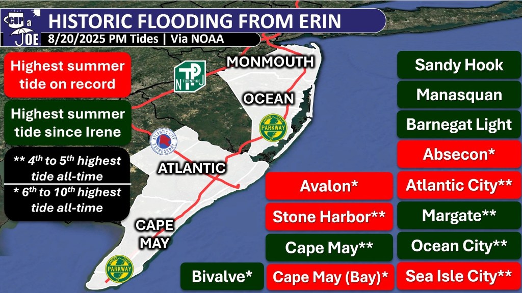
This is the first of two big tidal flooding events of the year.
Powerful onshore winds stacked the bays, bringing flooding conditions to five consecutive high tides. In the back bays, the constant onshore wind prevented the salt water from fully draining out before the next high tide.
Waretown, Ocean County, reported its highest tide on record. That being said, records only go back to 2018. Several gauges reported top 10 tidal heights since at least the year 2000. Numerous roads were closed due to tidal flooding and places that do not usually have tidal flooding did.
The most northern Jersey Shore town, Sea Bright, had 18 occupants removed from 12 flooded vehicles on Ocean Avenue, the only main road in town.
Atlantic City, Harvey Cedars, Little Egg Harbor and Seaside Heights had gusts over 50 mph on both Oct. 12 and 13. Sea Girt gusted to 51 mph on Oct. 13. Even Oct. 13 gusted over 40 mph in a few beach towns.
Bad hair days and frigid faces were common all winter long. January 2025 had 16 days with gusts over 40 mph somewhere within the New Jersey Weather Network stations, run by Robinson and the state climate office. That was a record high for the network
The winter also was the most or was tied for the greatest number of wind advisory for 46-57 mph wind gusts for Atlantic and Cape May counties since we started keeping track in 2006.
A few days were extremely windy.
Feb. 16-17: ACY Airport had the second highest wintertime gust on record, since 1943. It clocked in at 71 mph. Most shore counties gusted over 45 mph. Over 200,000 thousand people were without power throughout the state.
People have asked me for years if it’s been windier at the Jersey Shore in recent years. While it’s a hard sell after this winter, the answer is still no, it’s not gotten windier.
Thankfully, no deaths from the high surf and rip currents occurred.
While many of us typically associate hurricane season in New Jersey in September and October, this was a good reminder that hurricane season runs during our busiest time of the year at the coast, the summer.
2) The April Jones Road Fire
Via NJ Forest Fire Service
The Jones Road Fire, which was first spotted at 9:45 a.m. on April 22, was the fourteenth largest fire in the state’s period of record. It swallowed up 23 square miles in Ocean County, or a little over 15,000 acres, according to the NJDEP.
It started on April 22, 2025, from a bonfire that two teenagers did not put out all the way. Dry weather, strong winds, and low humidity helped the fire spread quickly.
Thousands of people had to leave their homes for safety, the Garden State Parkway closed, and smoke made the air bad even in New York City.
One commercial building and some outbuildings were destroyed, but no homes were lost and no one was hurt. Firefighters worked hard and stopped the fire completely on May 12, 2025.
From Jan. 1 to April 25, 662 wildfires occurred in New Jersey.
Last year through April 25, about half as many wildfires occurred.
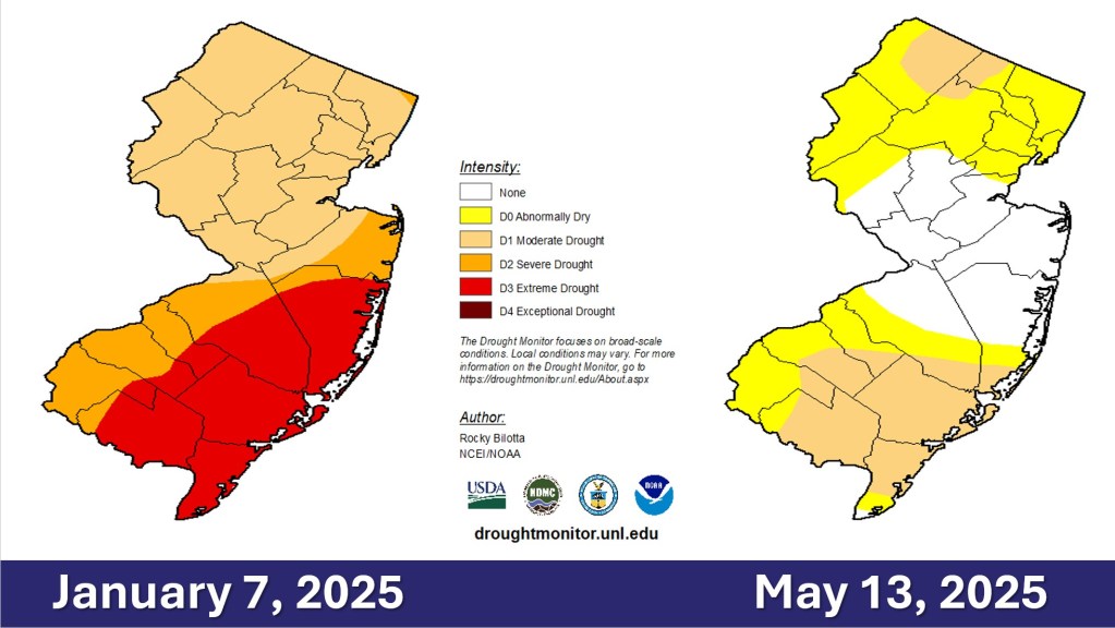
The difference was drought. When the Jones Road Fire began, that area was in a transitionary state between drought and no drought, known as abnormally dry conditions, according to the United States Drought Monitor.
1) Drought
The Jones Road Fire was caused, in part by the drought. The first four months of 2025 continued the significant drought that ramped up severely during the driest Fall on record in 2024.
Voluntary water restrictions were in place. New Jersey American Water urged customers to reduce water usage.
Via NJ Department of Environmental Protection
The United States Drought Monitor had at least part of the Jersey Shore in one of the four stages of drought until May 20. An ‘extreme drought,’ the second highest level of drought gripped Ocean County south to Cape May until early March.
Via the United States Drought Monitor
Groundwater from the Kirkwood-Cohansey aquifer in the southern half of the shore counties was ‘extremely dry” through May. Streamflows at the Jersey Shore were ‘extremely dry’ for 32 weeks in a row to start off the year.
The NJDEP continued the Drought Warning in the state on June 11. Even then, Cape May, Atlantic and most of Ocean counties were downgraded just to a Drought Watch, instead of normal conditions like the rest of the state.
The fifth wettest May on record dating back to 1895 busted the drought. However, it was only temporary.
A Drought Warning returned to the state on Dec. 5. Voluntary water restrictions are in place. Extremely dry streamflows and groundwaters returned during the Fall for most of the Jersey Shore. Most of Cape May County joins the western half of the state in drought according to the United States Drought Monitor.
More than likely, December will wind up drier than average across the coastal counties. That puts a lot of pressure on January and February to have more precipitation than average.
If not, more fires like the Jones Road one threatens going into Spring.
Finally…
Dave Robinson, the state climatologist, and I will compare our top weather events of the year during our Monthly Weather Roundup. Look for that on the Cup A Joe Weather and Drone website as well as social media channels on Dec. 30.
He put the October nor’easter above Hurricane Erin, but our number one and two events are the same. What do you think of the list? Leave me a note.
Have a fun, safe New Year. Looking forward to sharing more with you on Shore Local in 2026.
Joe Martucci and NJ State Climatologist Dr. Dave Robinson recap November 2025: near-average temperatures, very dry conditions (only ~2″ of rain), the end of a U.S.-landfall-free hurricane season, scattered early flurries, a disturbed polar vortex, and growing drought concerns heading into winter.
Recap the month of weather that was. It’s all Jersey, with two of Jersey’s best weather guys. New Jersey State Climatologist Dr. Dave Robinson as well as Meteorologist Joe Martucci, owner of Cup A Joe Weather and Drone take you through the temperatures, rain, snow, coastal flooding and much more. New episodes come out around the beginning of every month.
The Monthly Weather Roundup is sponsored by Jennifer Ansbach Coaching — helping students and adult learners Write. Revise. Rise. Learn more at JenniferAnsbach.com.
At the start of this month, I went to Sea Isle City to give a talk to the Garden Club. The group of ladies was nice, and one of them asked me a question that was a lot like this one.
“Has it been windier weather at the Jersey Shore lately?”
Sea Isle City isn’t the only town to ask this. From Cape May to Ventnor and points north, this has been a popular question during my public, and private, weather talks. The uptick in questions started in 2021 and 2022 and persisted. However, this may be a question of perception and not reality.
How has the wind changed at Jersey Shore?
Believe it or not, the winds have been calmer at Jersey Shore in recent decades.
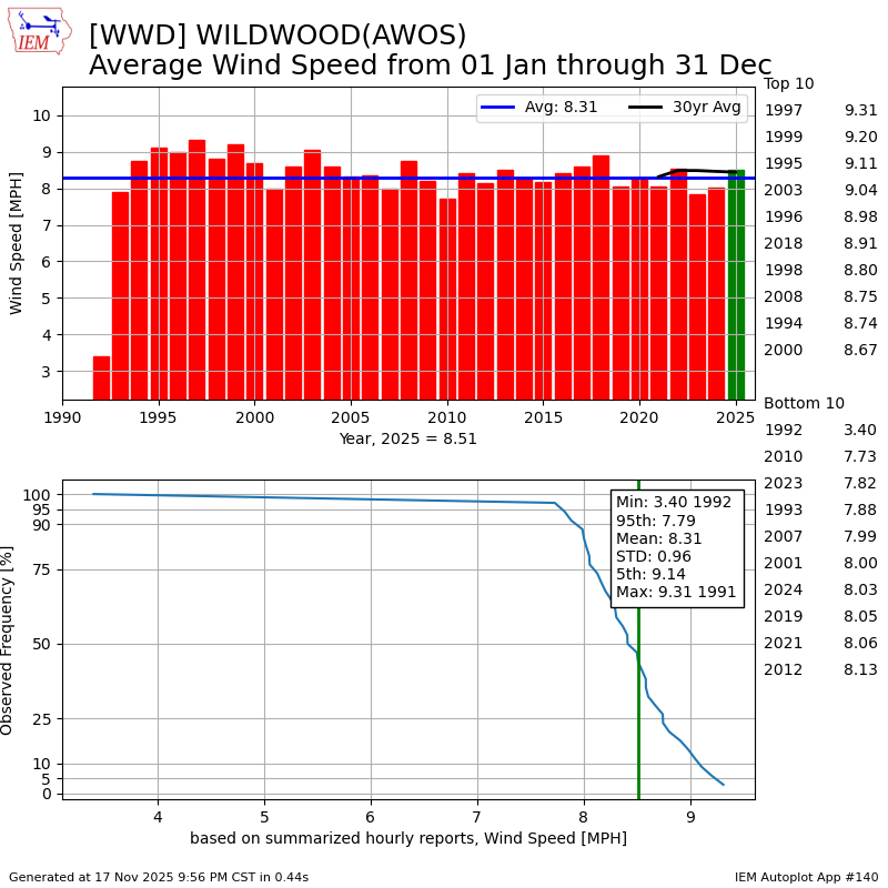
At Atlantic City International Airport in Egg Harbor Township, the average wind speed in 2024 was 8.11 mph, according to the Iowa Environmental Mesonet. While that was above the 7.8 mph average in 2023, wind speeds have been in decline for a while.
Consider that during the past 30 years, the trendline for winds decreased from about 8.7 mph to 8.2 mph. That’s not much, but it proves the point that the wind speed has not increased in recent years.
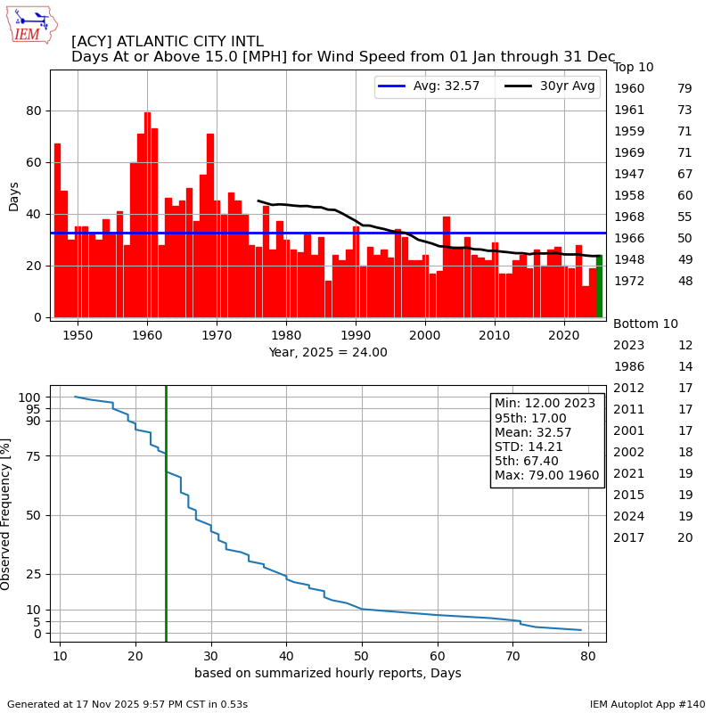
To prove this is true another way, I even sorted by the number of days in a year with sustained winds of at least 15 mph. That’s a breezy day.
Again, there’s been a slight decline in the number of days. As of Nov. 17, ACY Airport experienced 24 such days. That is more than the past two years, but the longer-term trend shows a decline.
It is interesting to see the big drop in the wind speeds that occurred in the 1970s. The long-term average dropped from 10.5 mph from 1947 to 1976, to 9.0 mph from 1977 to 2006.
More than likely, the wind equipment used at the airport changed at some point in the 1970s. That led to weakening wind speeds.
Going beyond ACY Airport, the Iowa Environmental Mesonet data in other places prove that the windier days are just perception. The average wind speed at Lower Township’s Cape May County Airport has remained consistent at around 8.2 mph since records began in 1992.
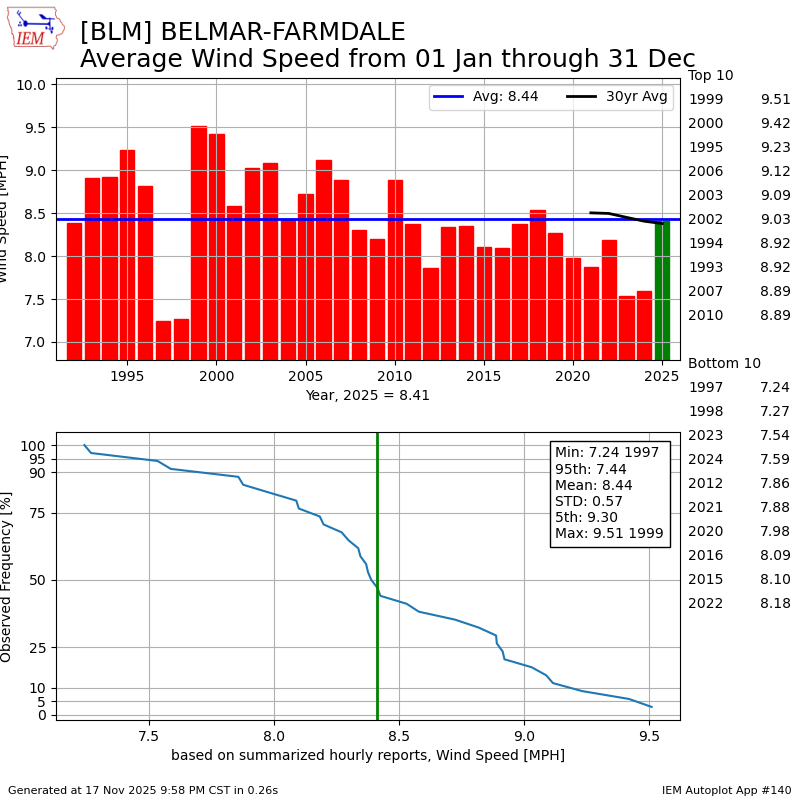
Meanwhile, at Monmouth County Executive Airport in Wall, the trendline is also pointing toward calmer years. 2025 is the first year that was as windy as at the average since 2018, getting to 8.4 mph through Nov. 17. Windier-than-average years were the norm from 1999 to 2007.
Have very windy days happened more often in N.J.?
It depends.
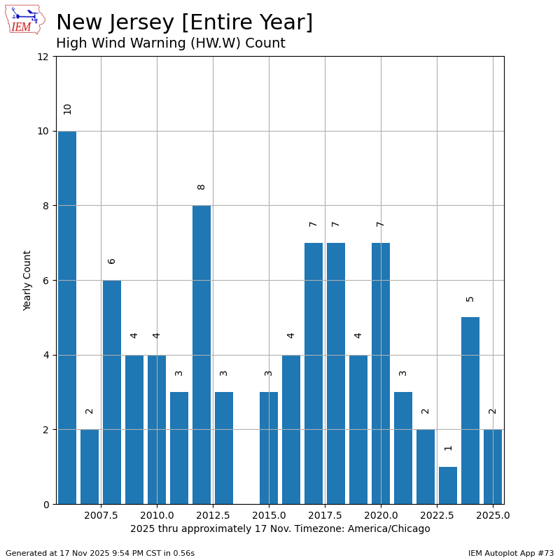
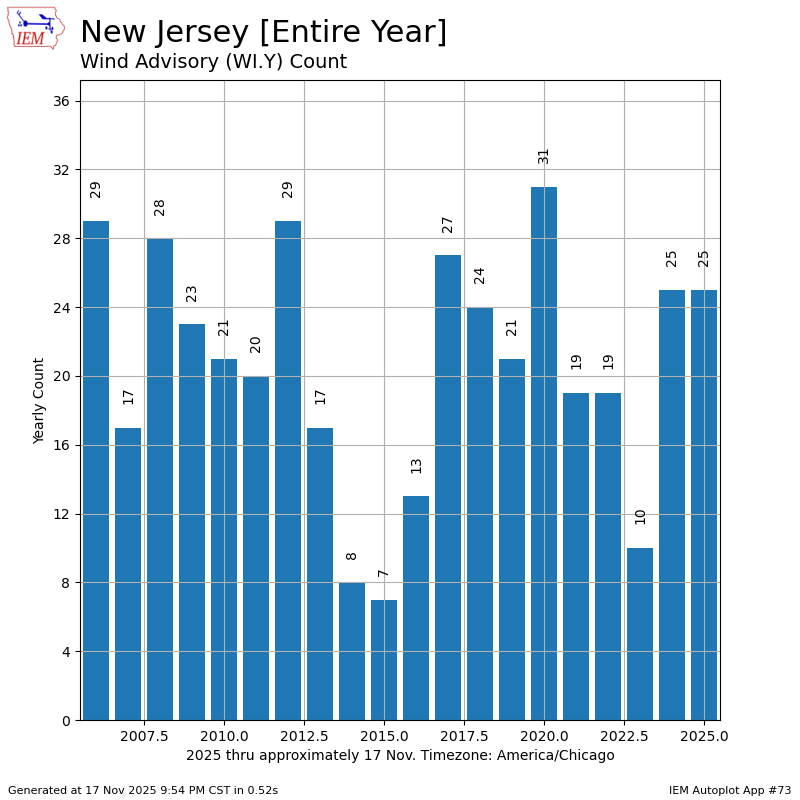
Since records began being kept in 2006, the trendline for the number of wind alerts issued by the National Weather Service has fallen over time in New Jersey.
High wind warnings, which are issued by the weather service when winds can damage life or property, occur 4.5 times a year, according to the mesonet. However, that’s a slight drop from the first 10 years of records, which was 4.7 times.
Meanwhile, wind advisories that are issued for nuisance wind issues saw a slight increase. The average since 2006 has been 20.7 times per year. The first 10 years of record keeping was 19.9, though.
With the average wind speed dropping over time, and the most severe winds happening slightly less often, don’t look too much into the bump up in wind advisories.
Why is it feeling windier in N.J.?
I don’t have any scientific evidence for this, but here’s my theory on why it’s felt windier in recent years.
We’re outside more.
From 2020 to 2021, in the depth of the COVID-19 pandemic, many of us that were healthy rekindled our relationship with the great outdoors. More walks and runs outside. More time in the garden or at cookouts. More time at the beach.
All of that may keep us in tune with the wind more than before. As outdoor workers will tell you, wind does impact the ability to get things done. So, perhaps that’s why.
Otherwise, the data says we must keep searching for answers because it hasn’t been windier.
Twenty-four/seven streaming weather channel now LIVE
Whether on your TV, your computer or your phone, get everything Jersey Shore weather, and drone, for free!
The Cup A Joe Weather and Drone Jersey Shore streaming weather channel is now live. From our daily weather forecasts to Tidal Flooding Talk, words from our sponsors and more, you’ll get the hyper-local information you deserve, without the hype.
You can submit your most scenic weather photos for the stream, also. Go to www.bit.ly/WxPhoto to put yours in. We’ll approve it and you’ll see it run, live, on your device. Just search for @joemartwx on YouTube or go to www.cupajoe.live to view it.
Joe Martucci, a Certified Broadcast Meteorologist and Digital Meteorologist, is the President and Director of Meteorology for Cup A Joe Weather and Drone. You can connect with him at cupajoe.live/.
The first snow of the season at the Jersey Shore is usually something to smile about. It’s light and fun. Maybe just a few flakes in the air or a quick snow shower that melts fast. It makes you think of cozy things: a warm fire, snow on the sand at the beach, or a surprise day off from school or work.
At two weather stations near the Jersey Shore – Atlantic City International Airport and Lower Township – the first snow average is 1.6 inches deep. That’s not much. Most people think it’s more fun than trouble.
However, sometimes the first snow is a big surprise.
Four times at Atlantic City International, and three times in Lower Township, the very first snowy day of the season dropped more than 6 inches. That’s a lot for the first one.
I love snow any time, but a huge first snow can catch everyone off guard. It’s like playing a big game without warming up, or running a race in brand-new shoes. Nobody is ready yet. Meteorologists might miss a forecasting tidbit. Road crews might not put out enough salt and plows. Drivers forget to go slow and careful like they do later in winter. That makes slippery roads extra dangerous.
On average the first real snow at the Jersey Shore waits until the second half of December. However, there are a few times in weather history when snow has been noteworthy and early.
December 5, 2002
In 2002 the first snow of the season at the Jersey Shore was a nor’easter that dropped more than 6 inches of snow.
Every county in New Jersey had snow, according to NOAA. An area of low pressure developed on a frontal boundary along the Gulf Coast states. Eventually, that low pressure moved through the Southeastern United States, went off the North Carolina coast and quickly raced northeast, according to Raymond C. Martin Jr. It was a nor’easter.
Perhaps more impressive was that these totals were greater than the snow seen the entire previous winter in much of South Jersey. This was in the middle of a long stretch of colder-than-average temperatures. The snow that fell took six days to fully melt across the area as high temperatures stayed below 35 degrees nearly every day from Dec. 4 to Dec. 10.
November 30, 1967
Before 2002, you had to go back 35 years to experience a first winter storm as significant for the Jersey Shore.
At ACY Airport 7.8 inches of snow fell, the second largest leading snowfall of the season on record (a late start in 2022 was higher). Lower Township experienced 3.0 inches of snow.
This is one of the largest first snows on record, and one of the earliest, too. Snow spread from western North Carolina to New England.
This wasn’t a 100% snowstorm; 3.2 inches of snow at ACY Airport mixed with a total of 3.98 inches of precipitation. In essence, about 10% of the precipitation that fell was snow. Still, it counts.
Places farther south saw less snow mixed in. By the time you went to Lower Township, the storm was all rain. The Cape May Bubble was still alive and well then, too.
The New York Times wrote that New York’s highways were covered in an icy sheen and many motorists going upstate had to sleep overnight in their cars.
The storm was tropical at first. It was a tropical depression that moved across Florida. It then transitioned from a warm-core, tropical storm, into a cold-core, nor’easter. Ready for the storm was a huge mass of cold air in the Northeastern United States. That turned what was warm rain into some snow.
December 8, 1928
The third biggest first snow of the season in Lower Township’s long stretch of weather records (back to 1897), was a pure snowmaker, even at the immediate coast.
Lower Township saw 9.6 inches of snow on 0.80 inches of precipitation, according to NOAA. That’s a snow ratio of 12:1, meaning this wasn’t a sloppy, wet mess of snow, either.
ACY Airport wasn’t around yet. However, Atlantic City kept snow records then and they were blanketed in 3.9 inches of snow. High temperatures stayed in the 30s for the next two days after that, keeping the snow on the ground, too.
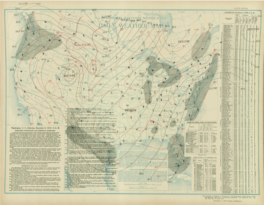
Archive weather maps from NOAA show that this was a coastal storm. Low pressure the morning of Dec. 8 was roughly 40 degrees north latitude, and 75 degrees west longitude. Today, that’s known as the “benchmark,” or the position coastal storms should cross to bring at least some snow to the coast. Winds were from the north or northeast at the Jersey Shore, pumping in the icy air.
The surface weather analysis for the Dec. 8, 1928 snow. The National Weather Service was a part of the United States Department of Agriculture then.
Thanksgiving Day, 1912
Talk about cold turkey. Nov. 28, 1912, brought a statewide blanket of snowfall, delivering a rare “White Thanksgiving.” In fact, it has an argument to claim a spot as the snowiest Thanksgiving on record statewide.
In Lower Township, 4.5 inches fell. In Atlantic City, Northfield and Tuckerton, 4.0 inches fell.
Barely an inch of snow fell in Taylor Ham land in the northern part of the state (yes, there’s a Central Jersey).
I imagine there were a lot of melted (dirt) roads that turned into ice at night. The days following it were well above freezing during the day, dropping a good bit below freezing at night.
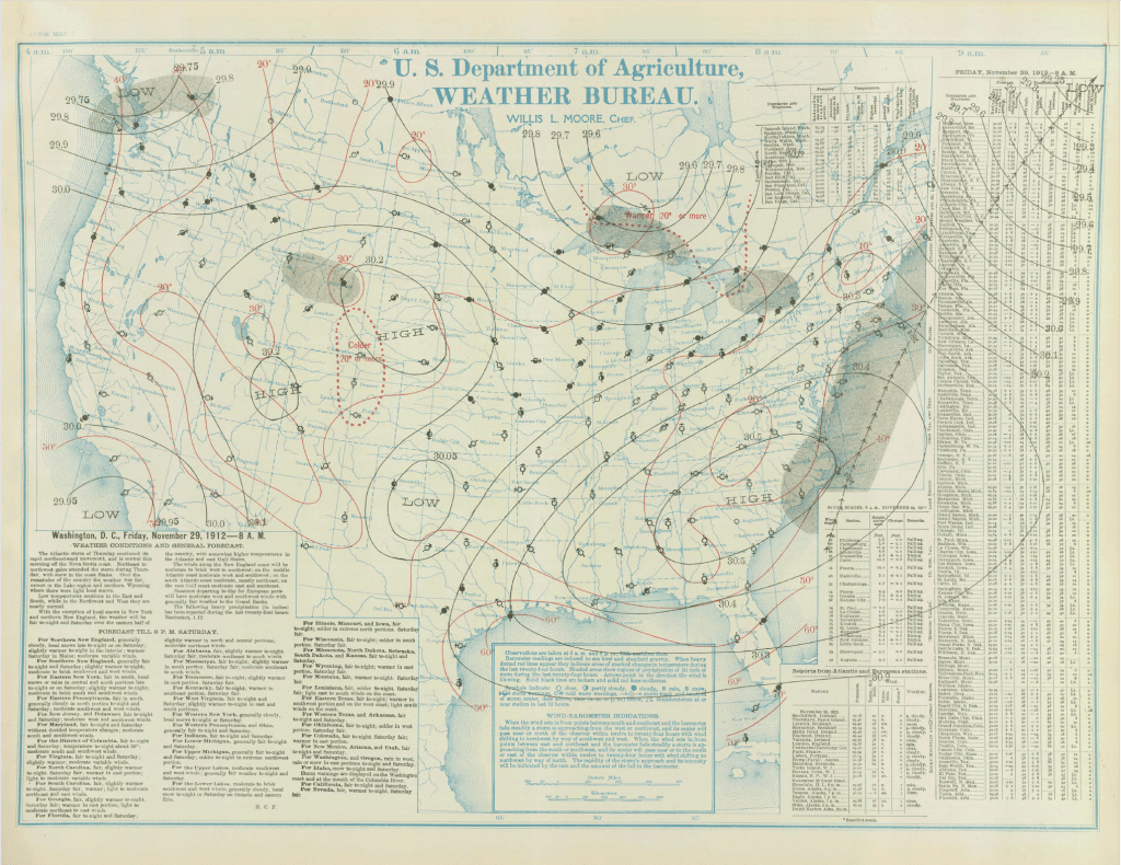
Like the early 1928 snow, this storm was a coastal storm. Known as a Miller A type storm, it began off the Georgia coast. It quickly moved north-northeast, passing almost right at that 40-degree north latitude, 75 degree west longitude benchmark.
The surface weather analysis for the Thanksgiving 1912 snow. The National Weather Service was a part of the United States Department of Agriculture then.
What are your snow thoughts?
Love it? Hate it? You want one snow and then that’s it? Drop me a note on social media or email.
Joe Martucci, a certified broadcast meteorologist and digital meteorologist, is also the president and director of meteorology for Cup A Joe Weather and Drone. You can connect with him at cupajoe.live/.
Occasionally, while I’m doing a public talk, I’ll be asked
“What are your thoughts on climate change, Joe?”
And, usually, I’ll respond with something like
“I’m not here to tell you my thoughts on climate change. Let me tell you what’s going on.”
Climate change is not a religion. You don’t believe in it or not.
There are facts and forecasts. Then, there’s what to think, not think, do or not do about it. That’s where your beliefs come in.
My job is the facts and forecasts.
In a warmer, wetter and more extreme New Jersey climate, that’s what I do here in this video series. Thanks for watching and email joe@cupajoe.live with any questions.
The facts and forecast vs. beliefs on climate change
Climate change isn’t a religion, you don’t believe in it or not.
🌀How climate change does, and does not, impact hurricanes
Tropical cyclones has and will see significant changes from climate change. However, climate change does not have its fingerprints on everywhere associated with hurricanes and tropical storms.
🏜️ Climate Change in New Jersey: Drought
More extreme precipitation in a climate changing worlds means drier dry weather and wetter wet weather. However, how much drought we’ve seen hasn’t changed in New Jersey.
🌧️❄️ Climate change in New Jersey: When it rains, it pours and snow is heavier, too.
Climate change has brought more rain and less snow. However, how it rains and snow also changed, too.
🌡️ Climate Change in New Jersey: Temperatures
Since records in NJ began in 1895, the average temperature rose by 4 degrees. Vineyards can now produce grapes are far north as Interstate-78, where in the 1970s, it was mainly limited to Cape May County. However, heat is the biggest killer in the United States on an annual basis and those numbers only get higher, even with air conditioning.
Climate Change in New Jersey: The complete guide
Follow my work: www.cupajoe.live Jolt your brand, advertise with me: joe@cupajoe.live
This article initially appeared in Shore Local Magazine on March 13. You can see it here.
The clocks have turned forward an hour, the buds are on the trees and now, it’s time to pack up and get a glimpse of summer, away from New Jersey. It’s spring break season.
That may mean a cruise, with dreams of laying on the pool deck with a drink in hand. It may mean cheering on the Philadelphia Phillies at their Spring Training stadium (BayCare Ballpark) in Clearwater (or in my case, Sarasota for the Baltimore Orioles).
Or, for our college readers, it means a few days you’ll never forget on the beach with your friends, and perhaps your future spouse considering that 1.5 million United States college students travel for spring break annually, according to Michigan State University.
Count me out, though. The only spring break trip I ever took was north, to Boston, for St. Patrick’s Day.
On the occasions people tell me they were disappointed in their spring break experience, the weather was to blame: It wasn’t hot enough, it wasn’t dry enough and the water wasn’t comfortable enough.
So, if and when you decide to pack up and travel south for a spell in March, here’s a look at a few popular destinations and the climate they have to offer.
Criteria
For a spring break destination, I’ll assume that you’re looking for a place with average highs between 75 and 85 degrees. You’ll look for places that are largely rain free. Low humidity is a bonus. Mornings should be comfortable – mild enough to stroll around in nothing more than a light layer.
“The Golf Capital of the World” is comfortable for golf, but don’t plan on pool or beach time here.
Afternoon highs in March rise from the low-60s to the upper-60s, on average, as the month goes on. You typically have mornings starting out in the 40s. So, it’s nice. There’s a 31% chance of some rain throughout the month, with a 7% chance of a ruin-your-outdoors-time, half inch of rain.
Myrtle Beach has a similar climate to New Jersey’s, so in March, expect a fair amount of cloudiness from large-scale storms, like nor’easters.
Panama City Beach, Fla.
A classic college spring break destination, Florida’s “Endless Summer” license plate doesn’t extend here. Temperatures are OK for hanging out on the sand. Morning lows start out 50-55 degrees, rising to 70-75 degrees, on average. That being said, there are days where highs will stay in the 60s, even 50s. A solid stretch of very warm weather is unlikely.
It is drier here, on average, than Myrtle Beach. There’s a 23% chance of rain on any given day in March. However, bigger soakers are more common here than Myrtle Beach.
Clearwater, Fla.
Now we’re getting to beach weather, and baseball weather, too. Average morning lows go from the mid-50s at the beginning of the month, to 60 degrees by the end of the month.
Daytime highs are regularly in the mid to upper-70s; 80s are a homerun at least a few times during the latter half of the month. The weather is nice for watching baseball, and for the sea, 60s occur with some regularity until March 22.
Rainfall occurs roughly 25% of days in March. Soaking rain over a half inch is uncommon, with a less-than-10% chance each day. Expect lots of sun this time of year.
Orlando, Fla.
Spring break with the little ones is extremely comfortable this time of year. Temperatures start out in the 50s during the morning and peak in the upper-70s to around 80 degrees on average. Plus, that swampy, muggy air is still weeks away.
March is still in the midst of dry season in Central Florida. Like Clearwater, there’s about a 25% chance of rain on any given day. Heavier rains, over a half inch, are uncommon.
South Florida/Florida Keys
You can break out those “Endless Summer” Florida license plates here, surfboard in tow.
Both coasts in South Florida boast average high temperatures in the upper-70s to low-80s in March, rising as the month goes on. The same is true for the Florida Keys.
Mornings are great for early exercise, or your caffeine boost with friends and family. Lows start out in the low to mid-60s. Similar to Central Florida, most days are without sticky weather, too.
It’s even drier here than the rest of Florida’s Panhandle. Expect plenty of sunshine in this part of the Sunshine State. From Key Biscayne to Key West, there’s roughly a 20% chance of rain on any given day. Downpours are downright rare.
Roughly from Jupiter on the East Coast, to Ft. Myers on the West Coast on south is in the Tropical Köppen Climate Zone. That means there’s an average of 64.4 degrees or higher every month of the year, with significant precipitation (at times).
Daily Chance of Precipitation from February to April for Miami (Red), Clearwater (Green) and Panama City Beach (Purple). Data via WeatherSpark.Average March temperature comparison for Florida in Panama City Beach, Clearwater and Miami. Data via WeatherSpark.
Punta Cana, Dominican Republic
Our first international destination of the list, Punta Cana is located on the eastern tip of the island nation. It’s firmly in the tropics, meaning March is a beach paradise.
Morning temperatures start out in the upper-60s to low-70s, with balmy breezes blowing. Afternoon highs reach the mid-80s. It is humid, however it’s not quite the stifling humidity you’ll see later in the year.
They average seven days with wet weather in March, but soaking rain is rare before March 20. They become more common afterwards.
Cancun, Mexico
Perhaps the most notorious spring break spot in North America, Cancun brings the heat during March.
March temperatures in Cancun are similar to Punta Cana. Mornings start out around 70 degrees and rise to the low and mid-80s during the afternoon, on average, according to WeatherSpark.com. Highs in the 70s and lows in the 60s are common in March, but that’s still fine for time in the water.
Precipitation occurs three or four days a month, on average. Furthermore, there’s a dip in the number of soaking rains this time of year. It’s rare for long-lasting rain to occur. That being said, it is fairly humid.
They say Aruba is “one happy island” and with its excellent March weather, it’s easy to see why. With dry conditions, not too much humidity and sunshine, there’s lots of time for the outdoors.
There’s just a 2-3 percent chance of rainfall on any given day during March, according to WeatherSpark. Cloud cover averages partly sunny during the month, too.
Temperatures start out in the very balmy upper-70s. Afternoon highs peak in the mid-80s. The humidity is high. However, the island breezes try to mix that out as much as possible.
Conclusion
If you’re looking to lay by the beaches, pools and bays for days, you need to be in South Florida, or farther south to enjoy these without worry. However, you can be in Clearwater watching the Phillies or in Orlando and get a stretch of comfortable shorts weather.
If you are wishing for warmer days but aren’t able to get away for spring break, have no fear; highs reach 75 degrees by March 31, on average, at Atlantic City International Airport, and April 26 at Sen. Frank S. Farley State Marina in Atlantic City.