Category: Latest Weather News

  • Waving goodbye to retired NJ State Climatologist Dr. Dave Robinson in June’s Weather Roundup

    Waving goodbye to retired NJ State Climatologist Dr. Dave Robinson in June’s Weather Roundup

    On June 30, 2026 Dave Robinson, the New Jersey State Climatologist since 1991 and Distinguished Professor at Rutgers University, retired.

    Dave Robinson is my birthday buddy (May 13th), research advisor (2013), Monthly Weather Roundup co-host, weather dad and friend.

    He is New Jersey climate. In the science world, knowing your stuff and communicating that stuff doesn’t always go hand in hand. He mastered both. He’d just ask quickly do a Zoom call for an interview as he would spit off a list of the top 10 most humid years in New Jersey’s history.

    “What I find incredibly inspiring about Dave is that he really was the essence of the office for several decades,” John Krasting, the incoming state climatologist said. “I’m going to be inheriting a wonderful program that has developed over the years into one of the leading state climate offices in the nation.”

    From left to right: Joe Martucci, Shawnie Martucci, Dr. Missy Holtzer, Dr. Dave Robinson, Christina Marguccio and Nick Marguccio during Dave’s retirement symposium in April 2026 at Rutgers University.

    My journey with Dr. Robinson began in 2013, during my last semester at Rutgers, when I wanted to do research for credit. The topic was dew point climatology, looking at moisture in the air across different parts of New Jersey.

    That report is still somewhere at the State Climate Office, or maybe at Dave’s home. Either way, it became a valuable learning experience. It also gave me the chance to meet Mat Gerbush, the assistant state climatologist, and a young Dan Zarrow, now Chief Meteorologist for NJ 101.5 and Townsquare New Jersey.

    After I graduated, it would be six years before Dave and I connected again.

    We were both at the New Jersey Emergency Preparedness Association conference in Atlantic City. He was there to give a talk. I was there to cover it as the new meteorologist for The Press of Atlantic City.

    For months, I had wanted to talk with him about New Jersey weather and climate. He had long been such a positive, trusted voice for science in the state. Still, I was nervous. We hadn’t talked in years. Would he remember me?

    I’m pretty sure he did.

    I walked up to him, we made small talk, and he asked about my career. Then I asked if he would be interested in doing a podcast episode with me for The Press. The show was called Something in the Air, and the idea was to look back at the previous month’s weather and place it in the larger context of climate.

    He said yes.

    The issue was figuring out how to do it remotely. He was in Piscataway. I was in Galloway. It was 2019: pre-COVID, pre-work-from-home, pre-remote-everything.

    We ended up using Stockton University’s TV program, where The Press produced its newsmagazine show, -30-. The first couple of episodes were shaky, but they worked. I can’t find video from those early days.

    Then COVID happened.

    No more TV studio. Instead, I used a new program called Zoom to interview him. No virtual backgrounds, no polished setup. Just my apartment and his kitchen.

    It worked, but it a far cry from today.

    There were many early struggles then, mainly my fault. I couldn’t get my external mic to work on Zoom. We’d have weird black spots on the video from the video boxes being the wrong space. I think one time I forgot to hit record. Still, he kept recording with me giving grace (perhaps having the same birthday helped).

    Eventually, the Something in the Air podcast turned into the Monthly Weather Roundup. We did it almost every month for years! Two of them, my other weather dad, Jim Eberwine, filled in.

    The longest break was after Lee Enterprises laid me off in June 2024. I took the summer off to regroup and when I started Cup A Joe Weather and Drone, the Monthly Weather Roundup came back in October 2024.

    The publicity of the episode has only grown since then. We’re back into audio podcasts, we create vertical videos from the episodes and break out parts of the show. Subtitles were added earlier in 2026 to increase your experience. All was good.

    When Dave told me he was retiring, I was happy for him. He loved his work. The days (and nights) were long. He has his kids, wife and most importantly, his grandkids. He loves to travel and now he could go during the semester!

    Even he doesn’t know how he’ll go from 60 hour work weeks to retirement. A Yankees game the day after his retirement and trip to Europe following that will help a bit. The reality will probably settle in later this summer. He’s also moving on from the Rutgers Global Snow Lab, which he ran for years.

    I hope you all enjoyed this iteration of the Monthly Weather Roundup. We documented every month of New Jersey weather for the past 7 years, giving important context that a brief sound bite or quote in an article can’t do.

    “People have some level of knowledge, but they often do not appreciate the full impact weather and climate have on every aspect of society. It affects transportation, the economy, tourism, emergency management, agriculture, the environment and daily life,” Robinson said.

    Now, I hope his daily life is full of snow for cross-country skiing, sunshine for his biking and time with his family.

    The Drought Situation: An Overview

    The month of June has brought alarming news regarding drought conditions across New Jersey. As of the end of June, areas stretching from Long Beach Island down to Cape May County are experiencing extreme drought (D3), while much of the state is under severe (D2) and moderate drought (D1) categories. Farmers, like those from Headley Family Farm in Eagleswood, are feeling the impact as irrigation systems struggle to maintain crops amidst low surface water and minimal precipitation.

    The next drought monitor report, set to be released on July 2nd, will provide an update on these conditions. Interestingly, while the highlands have seen some recovery with recent rains, the coastal areas remain critically dry. This disparity highlights the need for targeted rainfall to alleviate stress on water resources.

    Historical Context: Precipitation Deficits

    June’s precipitation levels reflect a troubling trend, with New Jersey averaging below-normal rainfall for the month. This marks the twenty-third out of the last twenty-six months with below-average precipitation, a situation not seen since the mid-1960s. Dr. Robinson notes that this persistent drought is characterized more by its longevity than by extreme dry spells. In the past two years, New Jersey has seen consistent deficits, with precipitation often falling to about 75% of normal levels.

    The coastal counties have been particularly hard hit, receiving only a fraction of the expected rainfall. For instance, Cape May recorded just over two inches for June, compared to the average of nearly four inches. This ongoing drought not only threatens crops but also raises concerns about water availability for residents and wildlife.

    The Transition of Dr. Dave Robinson

    As we reflect on the month’s weather, it’s also a moment to acknowledge Dr. Dave Robinson, who has been New Jersey’s state climatologist since 1991 (which as long as Joe Martucci’s been alive). As he prepares for retirement, he shares his mixed feelings about leaving a position he has held with pride. Robinson emphasizes the importance of proper timing in transitioning from a career, noting that he looks forward to spending more time with family and pursuing personal interests, including his writing projects.

    Dr. Robinson also highlights the importance of understanding climate patterns and their implications for agriculture and water resources in New Jersey. His insights serve as a reminder of the impact weather and climate have on our daily lives and the necessity for ongoing monitoring and research.

    Looking Ahead: What’s Next for New Jersey Weather?

    With the hot summer months ahead, the potential for heatwaves raises further concerns about drought conditions. New Jersey typically experiences its wettest month in July, but the current forecasts suggest that the areas most in need of rain may continue to face challenges. Robinson urges residents to be proactive in water conservation and to stay informed about local restrictions.

    As we move into July, the call for rain is more urgent than ever. The combination of high temperatures and low humidity could exacerbate the already dry conditions, leading to increased fire risks during holiday celebrations like Independence Day. Residents should be mindful of fire safety and follow local guidelines to protect their communities.

    Conclusion

    June has been a month of mixed emotions and pressing challenges for New Jersey. As we bid farewell to Dr. Robinson, we also prepare for the ongoing struggle against drought. Understanding these weather patterns is crucial for adapting to future climate challenges. For now, we hope for a shift in the weather that brings much-needed rain to our parched state.

    Frequently Asked Questions

    What is the current drought status in New Jersey?
    As of late June, New Jersey is facing severe drought conditions, particularly in coastal areas.

    How does the drought impact local farmers?
    Farmers are struggling with low surface water and are relying heavily on irrigation to sustain their crops.

    Why is Dr. Dave Robinson stepping down?
    Dr. Robinson is retiring to spend more time with family and pursue personal projects.
  • The heat NJ will get is HOTTER than our typical summer heat

    The heat NJ will get is HOTTER than our typical summer heat

    WEDNESDAY’S FORECAST | Today’s the warmup day (no pun intended) for what will be our most intense heat in years. 100F+ inland heat is still likely and all-time records are not ruled out either. Hydrate, hydrate, hydrate! I got your forecast.

    Stream our 24×7 Jersey Shore Weather Channel: https://www.youtube.com/live/Gn74OsNF4wQ

    Jolt your brand with the Shore’s top weather media company. Advertise today! joe@cupajoe.live

  • All-time record heat is possible as NJ heads into the 4th of July

    All-time record heat is possible as NJ heads into the 4th of July

    Meteorologist Joe Martucci is tracking NOAA’s HeatRisk forecast for Friday across the state, and most of New Jersey is in a Level 4, or extreme, heat risk. The key word here is “rare.” That’s the kind of heat setup expected later this week.

    Triple-digit heat is virtually guaranteed on Thursday, July 3, for inland Ocean and Monmouth counties. Inland Cape May and Atlantic counties are also likely to reach 100 degrees. Even on the Fourth of July, triple-digit temperatures remain very possible, with an even higher heat index making it feel hotter.

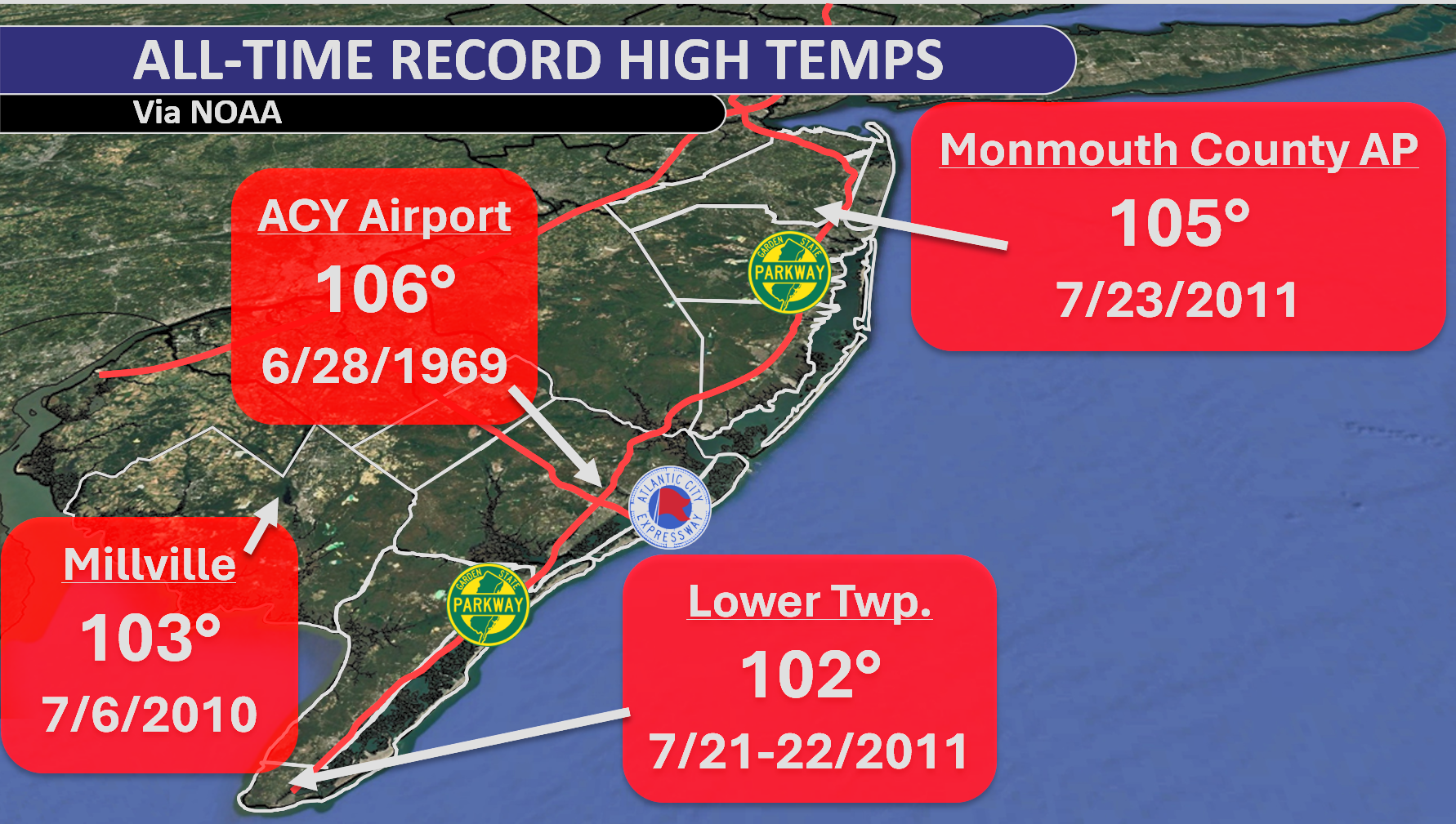
    New Jersey’s all-time record highs at these climate sites range from 102 to 106 degrees. Using NOAA data, Martucci notes that Monmouth County Airport and Millville both have about a coin-flip chance of breaking their all-time record highs on Friday. That means not just tying the record, but breaking it. Atlantic City International Airport has about a 40% chance as well.

    It’s not only the daytime heat that stands out. Overnight temperatures could also challenge all-time warm low temperature records. The highest chance appears to be in Lower Township on Friday, with about a 40% chance of breaking the warmest low temperature on record. Monmouth County Airport and Millville have a chance, too.

    No matter how you slice it, this is shaping up to be near-historic, and possibly record-breaking, heat heading into the Fourth of July.

    Two days of triple-digit heat are on the table, and the overnight warmth will offer little relief.

  • EXTREME heat is coming to NJ July 2nd-4th, even at the beaches.

    EXTREME heat is coming to NJ July 2nd-4th, even at the beaches.

    TUESDAY’S FORECAST | It’s one beautiful, comfortable, sunny day today. Then, we’re going uphill with temperatures and humidity. The heat wave expected Wednesday-Saturday will likely be the most sweltering this decade! I have safety tips and the forecast, here.

    Tired of water in your basement or crawlspace? Trust Finally Dry Waterproofing’s family-owned company to fix it right. We install permanent drainage solutions guaranteed for 2 ownerships with no limit! Get your FREE inspection at finallydrywaterproofing.net.

  • “Very strong” El Nino most likely this Fall & Winter. What does it mean for NJ?

    “Very strong” El Nino most likely this Fall & Winter. What does it mean for NJ?

    This is a look at our El Niño forecast from Columbia University. You’re looking at all the different computer model runs here, with those lines that kind of peak around September–October–November and then go down as we head toward February–March–April.

    Notice that more than half of them are showing that this is going to be a very strong El Niño, which is a 2°C or greater sea surface temperature anomaly in certain parts of the equatorial Pacific Ocean.

    But let’s look at the record — that’s 3.0°C — and there are even some model runs forecasting that as well. Either way, a very strong El Niño is certainly within the realm of possibility, and it’s virtually guaranteed that this will at least be a strong El Niño.

    What Is El Niño?

    El Niño is when you have warmer-than-average water temperatures across the equatorial Pacific Ocean, from roughly the coast of Peru in South America over to south of the Hawaiian Islands. You see a lot of those reds there in that circle.

    How Does That Impact Our Weather?

    In the next couple of months, it actually means fewer hurricanes. If you look at our hurricane forecasts from the National Hurricane Center or Colorado State University, you see fewer hurricanes due to stronger vertical wind shear (changes in wind direction and height) and greater trade winds. The stronger those east-to-west trade winds are, they can churn up the ocean and bring cooler water up to the surface — meaning again, fewer hurricanes.

    Now, what does this mean for our winter?

    We take a look at our Jersey Shore temperatures during the winter based on El Niño strength. Here’s one thing you notice: when you get to the strong and especially very strong categories, our temperatures get milder. There is a clear trend that as you move toward a stronger/very strong El Niño, you have a mild winter — particularly in the very strong case.

    What About Snowfall?

    We look at the snowfall anomaly (snow compared to average) at Atlantic City International Airport, which averages 17.4 inches. There’s a clear trend for a moderate El Niño to have a much snowier winter. But look at the very strong category — it’s kind of around the average.

    This is where we have to dive in a little bit further. Even though a very strong El Niño shows about average snowfall, it’s really varied. The graphic here shows the average snowfall in that white shaded box for ACY Airport and in Long Branch (pretty much the Jersey Shore). We saw back in 2015–16 above-average snowfall, but 1972–73 as well as 1997–98 saw next to nothing.

    So while generally I do believe that a very strong El Niño trends toward a less snowy than average winter, there are exceptions to this — and in some cases, pretty significant snowy exceptions like we saw in 2015–16.

    Short-Term Outlook

    In the short term, there’s not much to worry about. We’re going to have a less active than usual hurricane season — that’s good news. It doesn’t really have too much of an impact on our summer temperatures or precipitation.

    However, as we go into the winter, we’re going to have to pay close attention to what strength of El Niño we end up with.Quick Recap:

    A very strong El Niño means a much milder than average winter, but has mixed results as to how snowy our winter could be here in New Jersey.

    A strong El Niño means a slightly milder than average winter and well below average snowfall.

    • A strong El Niño means a slightly milder than average winter and well below average snowfall.
    • A very strong El Niño means a much milder than average winter, but has mixed results as to how snowy our winter could be here in New Jersey.
  • Saturday’s gloomy but not all that wet. DANGEROUS heat near the 4th?

    Saturday’s gloomy but not all that wet. DANGEROUS heat near the 4th?

    ☁️Gloomy and gray, but not as wet as you think today.
    🌦️ Showery, for some, Sunday PM
    ⚠️ 100F heat near the 4th

    Come visit Headley Family Farm at 120 Province Road in West Creek! It’s where farming the pines meets the Jersey Shore. Get your Jersey Fresh produce here. Open weekends and some weekdays. Call us at 609-848-3763 or follow us on Facebook, too!

  • NJ will be gloomy and gray through Saturday, but it’s not all that wet

    NJ will be gloomy and gray through Saturday, but it’s not all that wet

    FRIDAY’S FORECAST | I’ll tell you how wet I see this weekend being! Honestly, it has more bark than bite. Sure it’ll be gloomy and gray but it won’t be a straight up soaker. Let’s talk about it.

    Stream our 24×7 Jersey Shore Weather Channel: https://www.youtube.com/watch?v=dcPpb_VycOM

    Jolt your brand with the Shore’s top weather media company. Advertise today! joe@cupajoe.live

  • One more gloriously sunny day Thursday at the Jersey Shore

    One more gloriously sunny day Thursday at the Jersey Shore

    📹THURSDAY’S FORECAST | It’s another gloroiously sunny day today! It gets more unsettled for the weekend. However, you will have boat and beach time outside. I’ll tell ya when!

    Why settle for big chains? Choose Just4Wheels’ family-owned locations all across NJ! Rent brand-new sedans, passenger vans, box trucks and more today! Visit www.just4wheels.com or call 877-650-3500.

  • Machine Learning hints at accurate weather forecasts 30 days out, disproving “butterfly effect”

    Machine Learning hints at accurate weather forecasts 30 days out, disproving “butterfly effect”

    NOTE: This story is a Grok summarized article on “Atmospheric Predictability Beyond 30 Days with Machine Learning” by P. Trent Vonich and Gregory J. Hakim. It was released in the Artificial Intelligence for the Earth Systems journal by the American Meteorologist Society, which I am a part of.

    Weather Forecasts That Last Way Longer Than We Thought Possible

    Scientists have long believed that weather forecasts can only be really accurate for about two weeks. After that, tiny mistakes in the starting weather data grow so fast because of chaos (the “butterfly effect”) that the forecast becomes useless. A new study challenges that old rule using an AI weather model.

    What They Did

    Researchers took a popular AI weather model called GraphCast. This model is special because it can “learn” from data and also figure out how small changes in the starting weather affect the forecast days later.

    They didn’t just run normal forecasts. Instead, they tweaked the starting weather picture (called the initial conditions) for every day in 2020 — over 700 forecasts in total. They used math to find the best possible starting point that would make the forecast match what actually happened as closely as possible. They did this step by step, starting with short forecasts and slowly making them longer.

    They tested this on a big computer using two levels of precision (like using more decimal places for more accuracy).

    What They Found

    The results were surprising:At 10 days ahead, the tweaked forecasts had 86% less error than normal forecasts that started from regular weather data. Every single forecast got better — none failed.

    The forecasts stayed useful much longer. The weather patterns matched reality well out to about 27–28 days, and some skill lasted past 30 days. The errors grew at a steady rate, but started from a much better place, so they stayed smaller for longer.

    They also checked if the AI was just making smoother, less detailed forecasts (which would look better but be less useful). It wasn’t — the improved forecasts kept the right amount of detail and activity.

    What the “Tweaks” Looked Like

    The changes they made to the starting weather weren’t random or tiny. On average, they showed a clear pattern:They made the big tropical air loop (warm air rising near the equator and sinking farther north and south) stronger than in the normal weather data.

    This included:

    Making some ocean areas near the tropics a bit cooler or warmer in the right places Adding or removing moisture in patterns that matched real weather systems Changing how air rises and sinks over large areas

    These changes were about the same size as normal small errors in weather data. They weren’t crazy or unrealistic.

    Testing in a Different AI Model

    To make sure this wasn’t just a trick that worked only in one AI model, they took the improved starting points and used them in another AI model called Pangu-Weather.

    The other model also got better forecasts — about 21% less error at its best point (around day 4). It wasn’t as big an improvement as in the first model, but it was still clearly better than normal. This shows the better starting points helped in general, but some of the improvement was specific to the first model.

    Why This Matters

    This study shows that better starting weather data can push accurate forecasts well past the old two-week limit — at least for big weather patterns across the whole planet. It suggests the atmosphere might be more predictable at large scales than we used to think, and that current weather data has some fixable mistakes in big patterns like the tropical air loop.

    Important limits

    The scientists knew what the weather actually did later (they were looking backward). This isn’t yet possible in real-time forecasts.

    It works best for big, continent-sized weather features, not tiny storms or local details.

    It took a lot of computer power for each forecast.

    Bottom Line

    The old idea that weather becomes unpredictable after about two weeks may not be as strict as we thought — at least when we use smart AI tools to find better starting points. This doesn’t mean we’ll have perfect 30-day forecasts tomorrow, but it opens the door to much longer useful forecasts in the future if scientists can figure out how to find these better starting points in real time.

    The study is careful and well-tested. It doesn’t claim the atmosphere has no limits — it just shows those limits might be farther out than we believed when we start with smarter data.

  • 😎Lots of SUNSHINE in NJ’s forecast as much-needed rain leaves

    😎Lots of SUNSHINE in NJ’s forecast as much-needed rain leaves

    WEDNESDAY’S FORECAST | Sun, sun and more sun! It almost feels like September with the crisp air around. I recap your much needed rainfall totals from the past two days and break down just how wet the weekend will be.

    Stream our 24×7 Jersey Shore Weather Channel: https://www.youtube.com/watch?v=dcPpb_VycOM

    Jolt your brand with the Shore’s top weather media company. Advertise today! joe@cupajoe.live