In this episode, we explore the critical issue of coastal flooding and sea level rise, featuring expert insights from Dr. Wanyun Shao at the University of Alabama. We discuss risk assessment, social vulnerabilities, and practical measures for communities along the Atlantic and Gulf Coasts.
Experience Tidal Flooding Talk every Tuesday night, America’s leading show on coastal flooding resilience. Hosted by the New Jersey Coastal Coalition, which formed after Superstorm Sandy in 2012, it empowers leaders with dynamic workshops. Visit njcoastalcoalition.com to learn more!
Chapters 00:00 Introduction to Coastal Challenges 04:15 Understanding Flood Risks in Major Cities 10:33 Social Vulnerability and Flooding 16:50 Public Awareness and Preparedness 22:13 Strategies for Mitigating Flood Risks 27:39 Personal Reflections and Celebrations
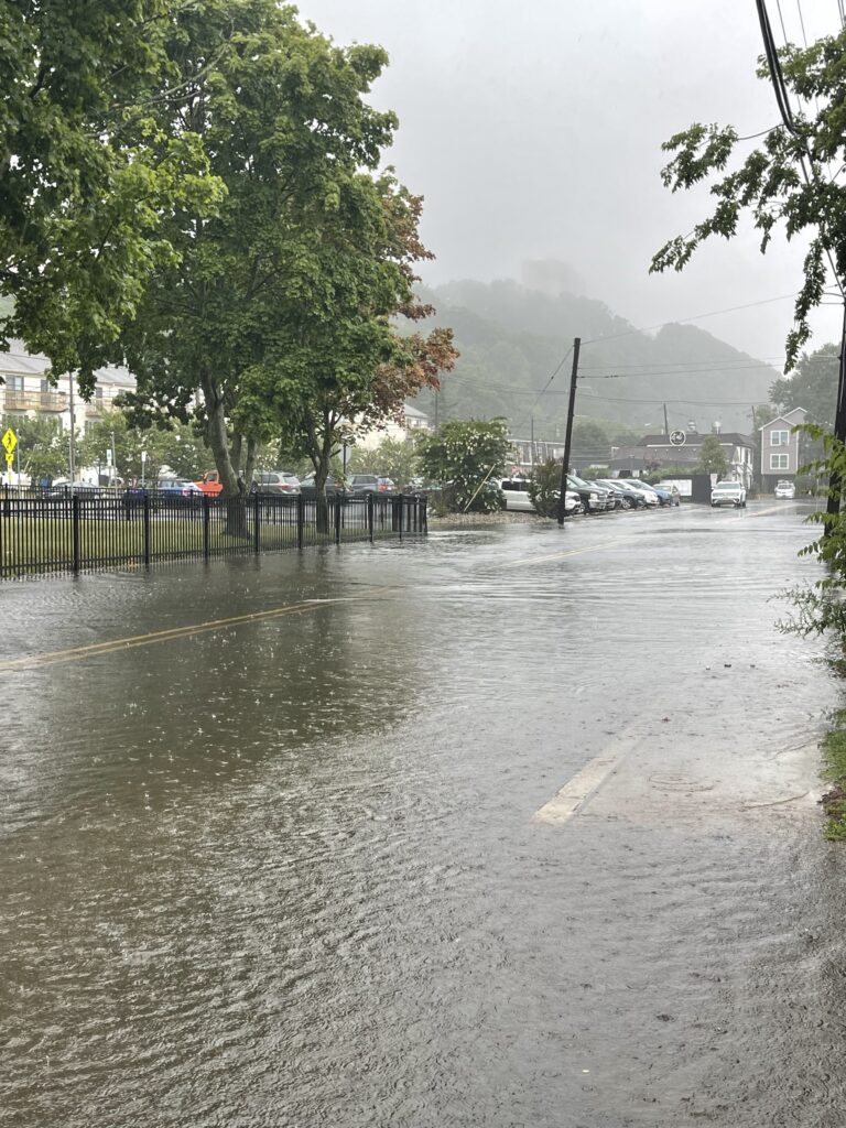
Tremendous flooding hit Monmouth County and parts of Ocean County Monday (July 6) after heavy rain moved through the area. This was not tidal flooding. The water came from rain alone.
Photos from across the region showed flooded roads, high water in neighborhoods and dangerous conditions for drivers. One of the most serious reports came from the BJ’s Wholesale Club in Ocean Township, where part of the roof collapsed. Thankfully, no injuries or deaths were reported, but the situation could have been much worse.
Flooding on Bay Avenue in Highlands (Monmouth County), looking north. Photo via Tony Flores
The National Weather Service received many flooding reports from the area. There were dozens of water rescues after people drove into water that was too deep for their vehicles. Major roads were also closed in several coastal communities. Jersey Shore University Medical Center in Neptune Township had flooding on the first floor and in the emergency room.
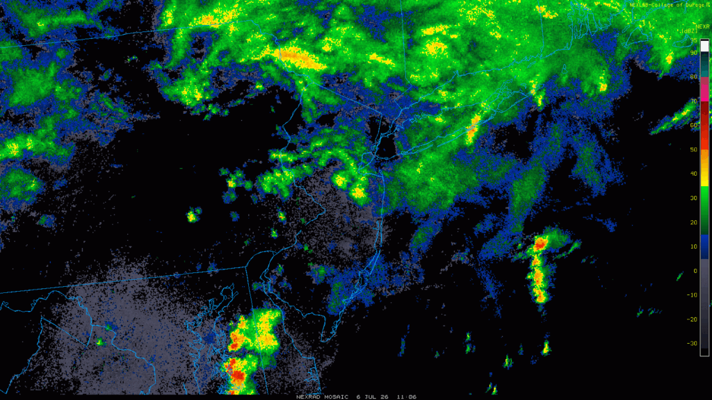
The flooding happened because several thunderstorms moved over the same areas again and again. Meteorologists call this “training.” It is similar to train cars moving over the same track. When storms train over one place, rainfall can pile up quickly.
Radar from Monday’s thunderstorms. Notice the yellows and reds moving north, up the Jersey Shore, with more coming from the west. That combination met up in eastern Monmouth County, where the most significant flooding occurred. (Via College of DuPgage / NOAA)
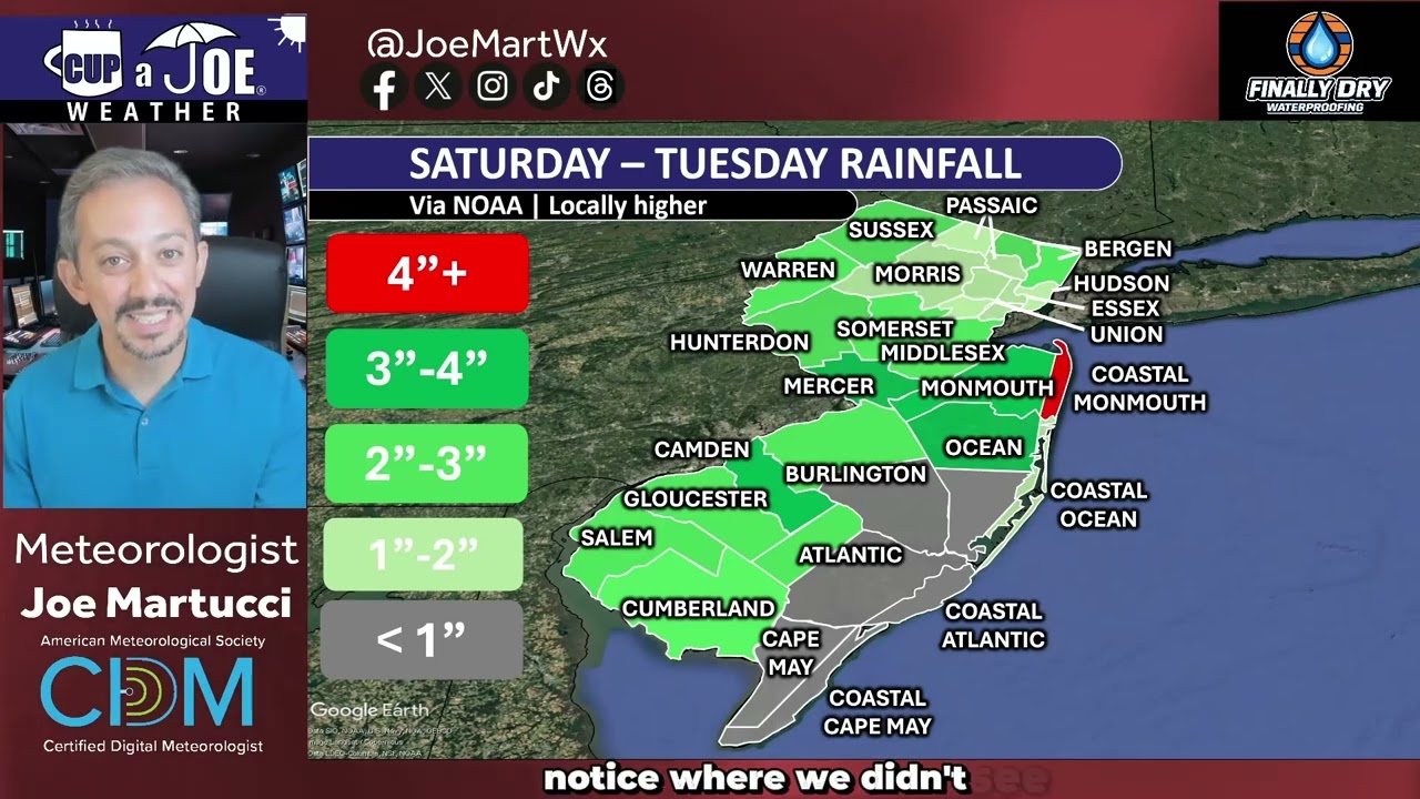
The heaviest rain fell in coastal Monmouth County, where some areas saw more than 4 inches. Inland Monmouth County and northern Ocean County also saw heavy rain, with many places picking up 3 to 4 inches.
Neptune Township had some of the highest rainfall totals, with more than 4.75 inches reported. Allentown, in western Monmouth County, received about 4.5 inches. Jackson Township in Ocean County also saw more than 4 inches of rain.
At one point in Neptune Township, the amount of rain that fell in 30 minutes and in one hour was considered a 1-in-100-year rainfall event. That means this kind of rainfall has about a 1% chance of happening in any given year. That extreme rain helps explain why Neptune, Ocean Township, Deal and nearby communities saw such serious flooding.
The heavy rain was not spread evenly across New Jersey. While parts of Monmouth, Ocean, Camden and Cumberland counties saw very heavy rain, far southeastern New Jersey saw much less. Atlantic City International Airport picked up only 0.14 inches of rain from Saturday to Tuesday.
That sharp difference shows why this storm was so unusual. Some coastal areas saw almost no rain, while nearby communities dealt with flooding, road closures, water rescues and damage from several inches of rain in a short amount of time.
📹TUESDAY’S FORECAST | Today is recovery day from the flooding that gripped Monmouth and northern Ocean counties. Elsewhere, it’s just a gloomy, damp day. Summer comfort returns later this week. Plus, a look at the tropics.
Tired of water in your basement or crawlspace? Trust Finally Dry Waterproofing’s family-owned company to fix it right. We install permanent drainage solutions guaranteed for 2 ownerships with no limit! Get your FREE inspection at finallydrywaterproofing.net.
Flooding developed quickly Monday morning across Monmouth County and northern Ocean County, creating dangerous travel conditions and forcing several road closures.
In Highlands, flooding was reported near Snug Harbor and Bay Avenue. Roads were closed in the Monmouth County Bayshore town because of high water.
Flooding was also reported in several other Monmouth County communities, including Wall, Monmouth Beach, Deal and Neptune Township. Ocean Avenue in Deal had flooding, and Route 71, a major road through the borough, was closed.
There were also water rescues reported in Neptune Township. A water rescue means someone drove into floodwater, got stuck and needed help getting out. This is why drivers should never go through flooded roads.
Jersey Shore University Medical Center in Neptune also had water on the first floor Monday, according to reports. In Ocean Township, the roof of the BJ’s on Route 35 partially collapsed during the storm.
Security camera footage shows the moment the roof collapsed at a BJ's store in Oakhurst, New Jersey. No injuries were reported. pic.twitter.com/1Bqk26n8vi
The past few hours have been dangerous for drivers in Monmouth County and northern Ocean County. If you do not need to travel Monday afternoon, it is best to stay off the roads.
It only takes 6 inches of moving water to knock a person off their feet. One foot of moving water can sweep away a car. About 20 inches of moving water can sweep away larger vehicles, including SUVs and trucks.
Flash flood warnings remained in effect Monday afternoon for parts of Monmouth and northern Ocean counties. Other flash flood warnings were in place from the Trenton area into far western Monmouth County. A flood watch also continued for the rest of the area through Monday evening because more heavy rain was possible.
The good news is that the worst of the rain appears to be over. However, more showers are expected through Monday night. Some of those showers could still be heavy at times, but they should not be as intense as what fell Monday morning.
From Monday afternoon into Tuesday morning, the main concern will be spotty heavy downpours. By sunrise Tuesday, a few showers may develop south of the Atlantic City Expressway. Farther north, especially in northern and eastern Monmouth County, conditions should be mostly dry by Tuesday morning.
Most places will only see a few more tenths of an inch of rain. However, some coastal communities could still pick up another 2 inches if a heavy downpour moves over the same area.
Conditions will improve by Wednesday, with a dry and pleasant day expected. Thursday will be seasonable. By Friday and Saturday, the weather pattern turns more humid, with the chance for scattered thunderstorms.
The end of the week does not look like a washout. Most outdoor plans should be fine, but people should keep an eye on the sky and stay updated on the forecast.
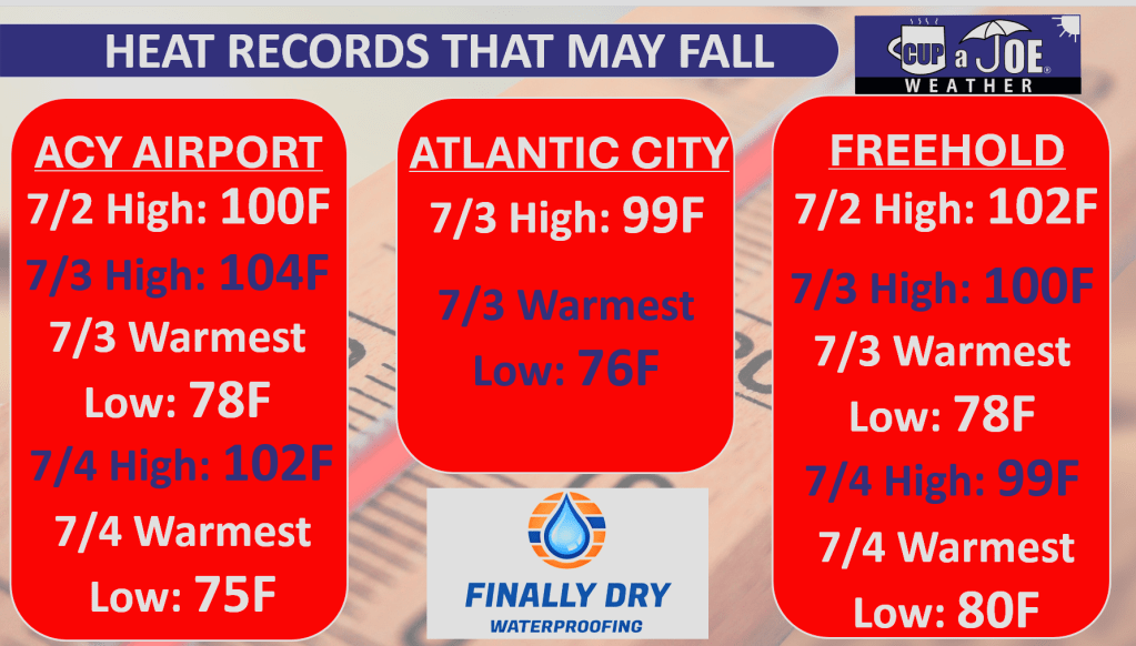
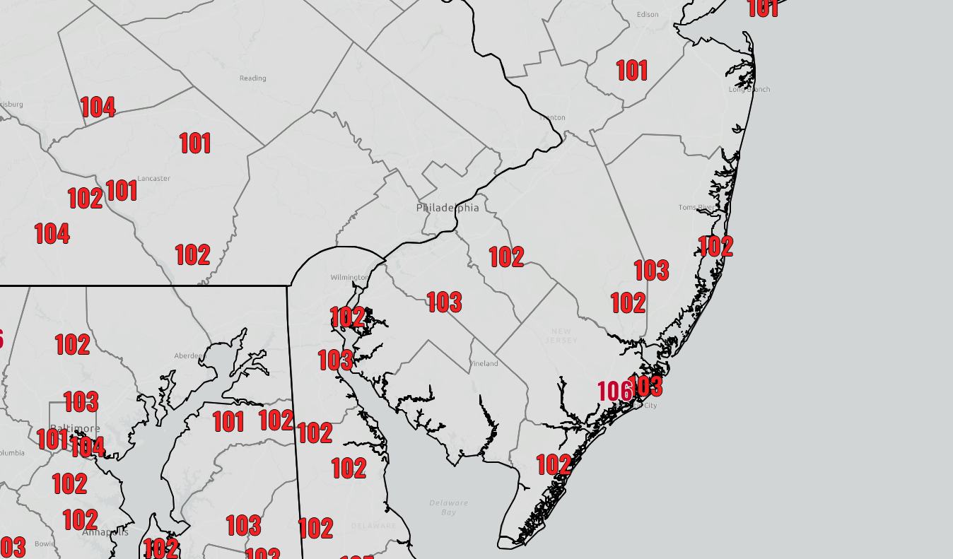
INDEPENDENCE DAY FORECAST | Happy 250! Today is the last day of the extreme heat, but it will take another round of storms tonight to break it. Here are the details! Stay hydrated!
Come visit Headley Family Farm at 120 Province Road in West Creek! It’s where farming the pines meets the Jersey Shore. Get your Jersey Fresh produce here. Open weekends and some weekdays. Call us at 609-848-3763 or follow us on Facebook, too!
🥵FRIDAY’S FORECAST | Dangerous heat continues across the region today with triple-digits inland and 90s at the beaches. Will storms threaten the region? Here’s the latest!
🏈 Your Rutgers tailgate headquarters! Parking at St. George is only 500 yards from SHI Stadium and features 500+ spots, clean restrooms, and quick access to River Road. It’s where Joe parks! Purchase at: www.rutgersparking.com
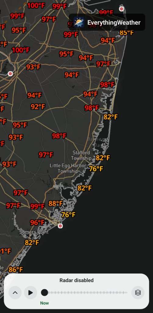
The cooling sea breeze is really doing its thing. It’s 76F in Atlantic City and in Harvey Cedars!
Sweltering inland though… A few spots hit already .
How’re you feeling?
910AM Thursday
Here’s why New Jersey is seeing record breaking heat over the next couple of days.
This satellite image tells the story of why New Jersey is baking under dangerous heat.
First, notice where the clouds are and are not. Across New Jersey, skies are mainly sunny. That sunshine is not an accident. A strong area of high pressure over the Mid-South is keeping rain and clouds away from us.
High pressure systems spin clockwise. You can see that on the satellite image, with clouds wrapping from Texas toward Michigan, then into Maine and down toward Florida. New Jersey is sitting inside the dry, sunny side of that circulation.
Think of the high pressure as stiff-arming the clouds and rain away from the Garden State. With the heat dome overhead, dry air in place, and strong sunshine beating down, the ground heats up even more.
On top of that, winds are coming from the west. During the summer, a west wind can help bring some of our hottest temperatures to the Jersey Shore region.
That combination is why heat warnings are in effect for inland Ocean, Atlantic and Cape May counties, as well as all of Monmouth County. This is life-threatening heat, especially for people without reliable air conditioning, outdoor workers, older adults, young children and anyone with health concerns.
730AM Thursday
🥵THURSDAY’S FORECAST | Our first of 3 days of record threatening heat is today, New Jersey. Stay hydrated, stay in the A/C and stay safe. I’ll tell you where the 4th of July fireworks has the best chance of happening dry, too.
Rent brand-new sedans, box trucks and vans today! Call Just4Wheels at 877-650-3500.
630AM Thursday
HOTTEST STRETCH OF THE 2020s | We’ve talked about it for days and now it’s here. Brutal, record threatening heat for the next 3 days. This is what we’re up against. Good news? It won’t be *all* that humid.
On June 30, 2026 Dave Robinson, the New Jersey State Climatologist since 1991 and Distinguished Professor at Rutgers University, retired.
Dave Robinson is my birthday buddy (May 13th), research advisor (2013), Monthly Weather Roundup co-host, weather dad and friend.
He is New Jersey climate. In the science world, knowing your stuff and communicating that stuff doesn’t always go hand in hand. He mastered both. He’d just ask quickly do a Zoom call for an interview as he would spit off a list of the top 10 most humid years in New Jersey’s history.
“What I find incredibly inspiring about Dave is that he really was the essence of the office for several decades,” John Krasting, the incoming state climatologist said. “I’m going to be inheriting a wonderful program that has developed over the years into one of the leading state climate offices in the nation.”
From left to right: Joe Martucci, Shawnie Martucci, Dr. Missy Holtzer, Dr. Dave Robinson, Christina Marguccio and Nick Marguccio during Dave’s retirement symposium in April 2026 at Rutgers University.
My journey with Dr. Robinson began in 2013, during my last semester at Rutgers, when I wanted to do research for credit. The topic was dew point climatology, looking at moisture in the air across different parts of New Jersey.
That report is still somewhere at the State Climate Office, or maybe at Dave’s home. Either way, it became a valuable learning experience. It also gave me the chance to meet Mat Gerbush, the assistant state climatologist, and a young Dan Zarrow, now Chief Meteorologist for NJ 101.5 and Townsquare New Jersey.
After I graduated, it would be six years before Dave and I connected again.
We were both at the New Jersey Emergency Preparedness Association conference in Atlantic City. He was there to give a talk. I was there to cover it as the new meteorologist for The Press of Atlantic City.
For months, I had wanted to talk with him about New Jersey weather and climate. He had long been such a positive, trusted voice for science in the state. Still, I was nervous. We hadn’t talked in years. Would he remember me?
I’m pretty sure he did.
I walked up to him, we made small talk, and he asked about my career. Then I asked if he would be interested in doing a podcast episode with me for The Press. The show was called Something in the Air, and the idea was to look back at the previous month’s weather and place it in the larger context of climate.
He said yes.
The issue was figuring out how to do it remotely. He was in Piscataway. I was in Galloway. It was 2019: pre-COVID, pre-work-from-home, pre-remote-everything.
We ended up using Stockton University’s TV program, where The Press produced its newsmagazine show, -30-. The first couple of episodes were shaky, but they worked. I can’t find video from those early days.
Then COVID happened.
No more TV studio. Instead, I used a new program called Zoom to interview him. No virtual backgrounds, no polished setup. Just my apartment and his kitchen.
It worked, but it a far cry from today.
There were many early struggles then, mainly my fault. I couldn’t get my external mic to work on Zoom. We’d have weird black spots on the video from the video boxes being the wrong space. I think one time I forgot to hit record. Still, he kept recording with me giving grace (perhaps having the same birthday helped).
Eventually, the Something in the Air podcast turned into the Monthly Weather Roundup. We did it almost every month for years! Two of them, my other weather dad, Jim Eberwine, filled in.
The longest break was after Lee Enterprises laid me off in June 2024. I took the summer off to regroup and when I started Cup A Joe Weather and Drone, the Monthly Weather Roundup came back in October 2024.
The publicity of the episode has only grown since then. We’re back into audio podcasts, we create vertical videos from the episodes and break out parts of the show. Subtitles were added earlier in 2026 to increase your experience. All was good.
When Dave told me he was retiring, I was happy for him. He loved his work. The days (and nights) were long. He has his kids, wife and most importantly, his grandkids. He loves to travel and now he could go during the semester!
Even he doesn’t know how he’ll go from 60 hour work weeks to retirement. A Yankees game the day after his retirement and trip to Europe following that will help a bit. The reality will probably settle in later this summer. He’s also moving on from the Rutgers Global Snow Lab, which he ran for years.
I hope you all enjoyed this iteration of the Monthly Weather Roundup. We documented every month of New Jersey weather for the past 7 years, giving important context that a brief sound bite or quote in an article can’t do.
“People have some level of knowledge, but they often do not appreciate the full impact weather and climate have on every aspect of society. It affects transportation, the economy, tourism, emergency management, agriculture, the environment and daily life,” Robinson said.
Now, I hope his daily life is full of snow for cross-country skiing, sunshine for his biking and time with his family.
The Drought Situation: An Overview
The month of June has brought alarming news regarding drought conditions across New Jersey. As of the end of June, areas stretching from Long Beach Island down to Cape May County are experiencing extreme drought (D3), while much of the state is under severe (D2) and moderate drought (D1) categories. Farmers, like those from Headley Family Farm in Eagleswood, are feeling the impact as irrigation systems struggle to maintain crops amidst low surface water and minimal precipitation.
The next drought monitor report, set to be released on July 2nd, will provide an update on these conditions. Interestingly, while the highlands have seen some recovery with recent rains, the coastal areas remain critically dry. This disparity highlights the need for targeted rainfall to alleviate stress on water resources.
Historical Context: Precipitation Deficits
June’s precipitation levels reflect a troubling trend, with New Jersey averaging below-normal rainfall for the month. This marks the twenty-third out of the last twenty-six months with below-average precipitation, a situation not seen since the mid-1960s. Dr. Robinson notes that this persistent drought is characterized more by its longevity than by extreme dry spells. In the past two years, New Jersey has seen consistent deficits, with precipitation often falling to about 75% of normal levels.
The coastal counties have been particularly hard hit, receiving only a fraction of the expected rainfall. For instance, Cape May recorded just over two inches for June, compared to the average of nearly four inches. This ongoing drought not only threatens crops but also raises concerns about water availability for residents and wildlife.
The Transition of Dr. Dave Robinson
As we reflect on the month’s weather, it’s also a moment to acknowledge Dr. Dave Robinson, who has been New Jersey’s state climatologist since 1991 (which as long as Joe Martucci’s been alive). As he prepares for retirement, he shares his mixed feelings about leaving a position he has held with pride. Robinson emphasizes the importance of proper timing in transitioning from a career, noting that he looks forward to spending more time with family and pursuing personal interests, including his writing projects.
Dr. Robinson also highlights the importance of understanding climate patterns and their implications for agriculture and water resources in New Jersey. His insights serve as a reminder of the impact weather and climate have on our daily lives and the necessity for ongoing monitoring and research.
Looking Ahead: What’s Next for New Jersey Weather?
With the hot summer months ahead, the potential for heatwaves raises further concerns about drought conditions. New Jersey typically experiences its wettest month in July, but the current forecasts suggest that the areas most in need of rain may continue to face challenges. Robinson urges residents to be proactive in water conservation and to stay informed about local restrictions.
As we move into July, the call for rain is more urgent than ever. The combination of high temperatures and low humidity could exacerbate the already dry conditions, leading to increased fire risks during holiday celebrations like Independence Day. Residents should be mindful of fire safety and follow local guidelines to protect their communities.
Conclusion
June has been a month of mixed emotions and pressing challenges for New Jersey. As we bid farewell to Dr. Robinson, we also prepare for the ongoing struggle against drought. Understanding these weather patterns is crucial for adapting to future climate challenges. For now, we hope for a shift in the weather that brings much-needed rain to our parched state.
Frequently Asked Questions
What is the current drought status in New Jersey? As of late June, New Jersey is facing severe drought conditions, particularly in coastal areas.
How does the drought impact local farmers? Farmers are struggling with low surface water and are relying heavily on irrigation to sustain their crops.
Why is Dr. Dave Robinson stepping down? Dr. Robinson is retiring to spend more time with family and pursue personal projects.
WEDNESDAY’S FORECAST | Today’s the warmup day (no pun intended) for what will be our most intense heat in years. 100F+ inland heat is still likely and all-time records are not ruled out either. Hydrate, hydrate, hydrate! I got your forecast.





 INDEPENDENCE DAY FORECAST | Happy 250! Today is the last day of the extreme heat, but it will take another round of storms tonight to break it. Here are the details! Stay hydrated!

 already
  .
.