Stream our 24×7 Jersey Shore Weather Channel: https://www.youtube.com/live/Gn74OsNF4wQ
Jolt your brand with the Shore’s top weather media company. Advertise today! joe@cupajoe.live


Stream our 24×7 Jersey Shore Weather Channel: https://www.youtube.com/live/Gn74OsNF4wQ
Jolt your brand with the Shore’s top weather media company. Advertise today! joe@cupajoe.live
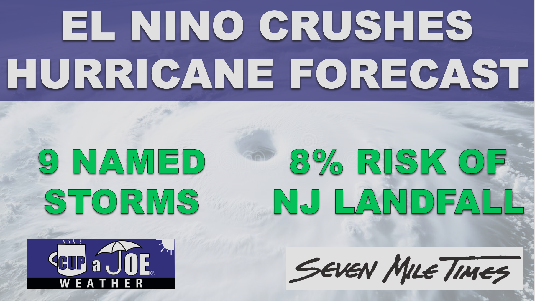
Strengthening El Nino Brings Quiet Hurricane Forecast, but…
By: Joe Martucci, Certified Broadcast and Digital Meteorologist
Owner, Cup A Joe Weather and Drone
A rapidly strengthening El Nino – one that could be the strongest on record – is helping to make the Atlantic hurricane forecast much quieter than usual. That is good news for New Jersey, but it does not mean the coast is in the clear.
I spoke with Levi Silvers, a research scientist at Colorado State University, on our Tidal Flooding Talk podcast from the New Jersey Coastal Coalition. New episodes come out Tuesday evenings.
Silvers said Colorado State University lowered its hurricane forecast again during its July 8 update. The forecast now calls for nine named storms, four hurricanes and one major hurricane (category three, four or five) this season. That is below average in all three categories.
| July 8th CSU Hurricane Forecast | Initial CSU Hurricane Forecast | Average Atlantic Season | |
| Named Storms | 9 | 13 | 14.4 |
| Hurricanes | 4 | 6 | 7.2 |
| Major Hurricanes (Category 3, 4, 5) | 1 | 2 | 3.2 |
Table 1. The Colorado State University Hurricane Forecast at different points of 2026, compared to average.
Colorado State uses the 1991 to 2020 average, the same time period used by NOAA’s National Hurricane Season.
The main reason for the quieter forecast is El Niño in the Pacific Ocean.
El Niño is a large weather pattern that has to do with water temperatures in the Pacific Ocean along the Equator. When the water is colder than average, it’s called La Niña. El Nino happens when it is warmer than average, it’s El Niño.
Figure 1. Sea surface temperatures, compared to average, for July 8, 2026. Note the bright reds off the western coast of South America. Those above average ocean temperatures is El Nino, and helps to reduce the amount of named storms this hurricane season in the Atlantic Ocean. Via TropicalTidbits.
However, its impacts spread far from there. During many El Niño years, stronger wind shear, or change in wind direction with height, develop high above the Atlantic Ocean and Gulf of Mexico.
Wind shear is bad news for tropical storms and hurricanes. Tropical systems need to stand tall and stay organized. When winds change direction with height, storms can get tilted, stretched or torn apart.
Silvers said that is what Colorado State expects this year.
“As things start to form, they tend to get pulled apart,” Silvers said.
Sea surface temperatures are also playing a role. Silvers said the Atlantic Ocean is not as warm as it was in recent years. Warm ocean water is the fuel for tropical storms and hurricanes, needing to be at least 79 degrees for tropical development. When the water is not as warm, storms have less energy to work with.
For New Jersey, the forecast is mostly encouraging.
Colorado State also looks at the chance of a tropical system impacting specific coastal areas. Silvers said New Jersey normally has about a 23% chance of being impacted by a named storm somewhere along the coastline during hurricane season. This year, Colorado State puts that chance at 8%.
That is less than half of the normal risk. Still, 8% is not zero.
He also said the chance of New Jersey being impacted by a hurricane is 2%.
| July 8th CSU 2026 Hurricane Forecast | Average Atlantic Season | |
| Named Storms | 8% | 23% |
| Hurricanes | 2% | 7% |
| Major Hurricanes (Category 3, 4, 5) | Less than 1% | 1% |
Table 2. The likelihood of a tropical system impacting NJ in 2026, compared to average.
That is welcome news, especially for coastal communities that watch every storm during the heart of hurricane season. However, New Jersey does not need a direct hit from a major hurricane to have problems.
A storm passing offshore can still bring coastal flooding, beach erosion, dangerous surf and rip currents. A weaker tropical storm or leftover tropical moisture can also bring heavy rain and freshwater flooding. Sometimes, the worst impacts here come from the tidal flooding not wind. Just last year, Hurricane Erin brought the most severe summertime flooding on record for much of the South Jersey shoreline, but without a drop of rain.
In Avalon, our in-house Tidal Flooding Dashboard through our ShorelySafe program shows that the Aug. 21, 2025 tidal flood was the tenth highest all time. The tide gauge peaked at 7.83 feet above mean lower low water. That’s considered major flood stage by NOAA, sitting right below the flooding experienced on Oct. 27, 2018.
Figure 2. Flooding in Avalon during Hurricane Erin on Aug. 21, 2025. It was the highest summertime tide on record for the Borough. Via Borough of Avalon
The biggest wild card is the Atlantic Ocean itself. Silvers said trade winds could still change in a way that allows parts of the tropical Atlantic to warm quickly. If that happens, storms could have more energy available, even with El Niño creating wind shear.
Right now, though, Silvers said that does not appear likely.
Colorado State will issue another hurricane season update in early August. After that, updates will come more often as forecasters watch conditions closer to the peak of the season.
For New Jersey, the message is simple: this hurricane season looks quieter than usual, but the coast should still stay ready.
It only takes one storm to turn a quiet season into a serious one.
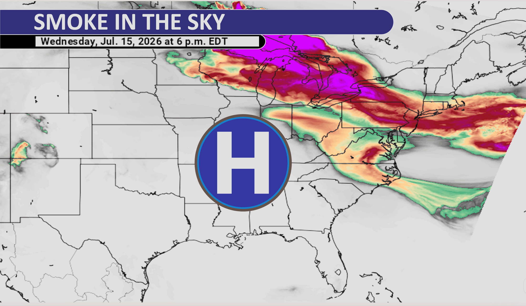
Wildfire smoke from Canada will bring hazy skies and poor air quality to New Jersey this week.
The first round of smoke is expected Tuesday afternoon and evening. A second, stronger round should arrive Wednesday afternoon and continue into the evening. Some people may even notice a campfire-like smell Wednesday.
A high-pressure system over the central United States is creating northwest winds. Those winds are carrying smoke from wildfires in Ontario and other parts of Canada toward New Jersey.
About 800 wildfires were active across Canada as of Tuesday, July 14.
The smoke will arrive as New Jersey also deals with high heat and humidity Wednesday. The combination could produce milky skies, reduced air quality and the smell of smoke across parts of the state.

🌡️TUESDAY’S FORECAST | We have a 5 day heat wave starting Wednesday and even the beaches are gonna be close to 100F tomorrow. Enjoy the summer comfort today!
Tired of water in your basement or crawlspace? Trust Finally Dry Waterproofing’s family-owned company to fix it right. We install permanent drainage solutions guaranteed for 2 ownerships with no limit! Get your FREE inspection at finallydrywaterproofing.net.
Go with Joe to Bermuda: https://cupajoe.live/joe-martucci-cruise-to-bermuda-fall-2027-sign-up/

Summer’s in full swing- and we’re still singing about winning tickets for summer concerts at ParkStage in Freehold! 🎶 🎤 🎶


Enter to win four tickets to either of their next two concerts!
🎵 Brantley Gilbert on Thursday, July 30th
🎵 Jason Isbelle and the 400 Unit on Friday, July 31st
Type ‘Brantley’ or ‘Jason’ in the DM to indicate which concert you want to enter. Type ‘Both’ if you want to enter for both concerts. Enter by July 24 at 5AM to win! 🎟️🎟️🎟️🎟️
Good Luck!

SATURDAY’S FORECAST | It is quiet and muggy as we wake up, but showers and storms will develop this afternoon and evening, especially for southern areas.
Come visit Headley Family Farm at 120 Province Road in West Creek! It’s where farming the pines meets the Jersey Shore. Get your Jersey Fresh produce here. Open weekends and some weekdays. Call us at 609-848-3763 or follow us on Facebook, too!

📹FRIDAY’S FORECAST | Same humidity, higher heat. The inland heat index will reach 100F.
For some, HEAVY downpours happen later today. How’s the weekend?
🏈 Your Rutgers tailgate headquarters! Parking at St. George is only 500 yards from SHI Stadium and features 500+ spots, clean restrooms, and quick access to River Road. It’s where Joe parks! Purchase at: www.rutgersparking.com .

🌦️THURSDAY’S FORECAST | Self-destructive sunshine today. We got from sun to storms. And those storms pose a risk for power outages plus flooding rain too. I’ll tell ya when the window for rain opens and a 50-50 summer weekend ahead.
Why settle for big chains? Choose Just4Wheels’ family-owned locations all across NJ! Rent brand-new sedans, passenger vans, box trucks and more today! Visit www.just4wheels.com or call 877-650-3500.

WEDNESDAY’S FORECAST | It’s not extremely hot, it’s not extremely wet, it’s comfortable across the coastal counties! 70s and 80s for highs. Storms return to the forecast Thursday. Will it be OK for the weekend? Tune in!
Stream our 24×7 Jersey Shore Weather Channel: https://www.youtube.com/live/Gn74OsNF4wQ
Jolt your brand with the Shore’s top weather media company. Advertise today! joe@cupajoe.live

The heat that hit the Jersey Shore from July 1 to July 5 was not normal summer heat.
It was rare, dangerous and even deadly.
In New Jersey, 29 people died during the stretch of extreme heat, according to reports. Heat is often the deadliest type of weather in the United States, and this heat wave showed why.
The biggest number came from Atlantic City International Airport. On the Fourth of July, the airport reached 106 degrees. That tied the hottest temperature ever recorded there.
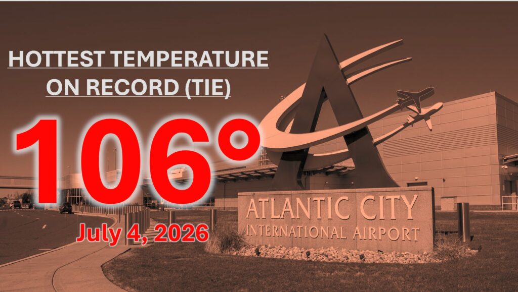
Several daily records were also broken during the heat wave.
On July 2, Millville reached 100 degrees. Atlantic City International Airport hit 103 degrees that same day. More records were broken on July 3 at Atlantic City International Airport, Millville, Atlantic City Marina and Freehold.
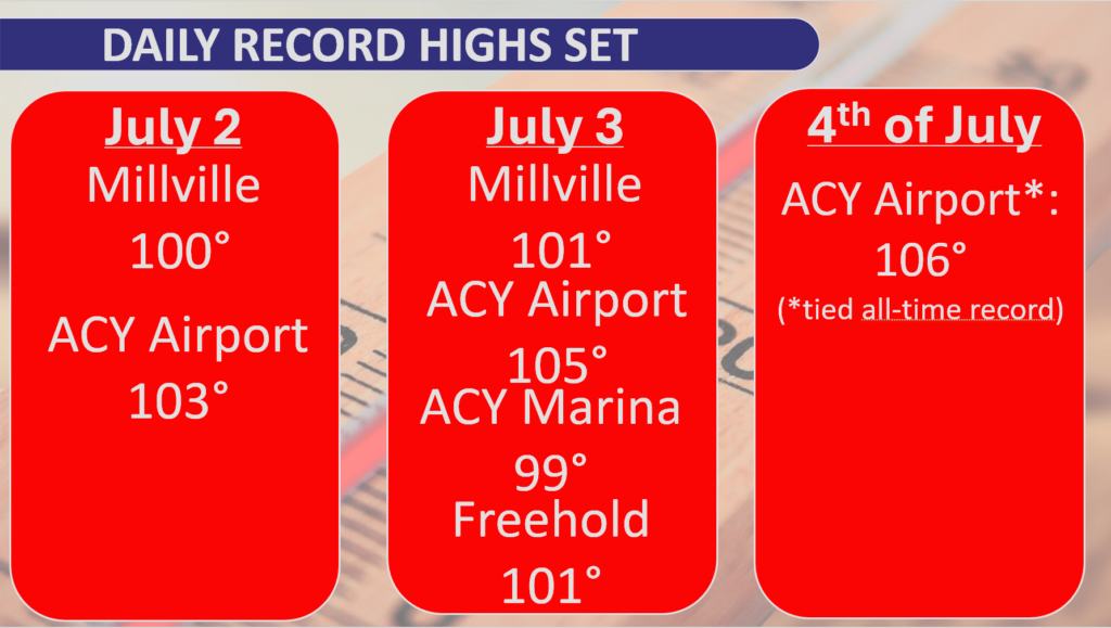
Then came July 4, when Atlantic City International Airport tied its all-time record high of 106 degrees.
The nights were also unusually hot.
For three nights in a row, overnight temperatures stayed near record levels. From the night of July 3 into July 4, Atlantic City International Airport never dropped below 80 degrees. That is one of the warmest nights ever recorded there.
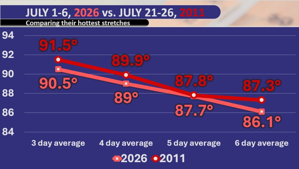
The last heat wave close to this one happened in July 2011. That was also when Atlantic City International Airport reached 106 degrees.
When comparing the July 2026 heat wave to the July 2011 heat wave, this one was close, but just below the 2011 stretch. Still, for inland parts of the coastal counties, this was likely the second or third hottest stretch on record going back to the 1940s.
So why did it get so hot?
A strong area of high pressure was sitting over the Mid-South. High pressure spins clockwise. That helped send hot air from the Gulf region into the Midwest and then toward New Jersey.
By Friday and Saturday, winds turned more from the west and northwest. That kept the air a little less humid than usual. Dew points were mostly in the 60s instead of the very sticky 70s.
That drier air helped temperatures climb even higher.
When the air is very humid, it can be harder for temperatures to rise as much. But when the air is dry, the sun can heat the ground more easily. That is why desert cities like Phoenix can reach the 110s, while a humid city like Miami rarely gets above 99 degrees.
Climate change also played a role.
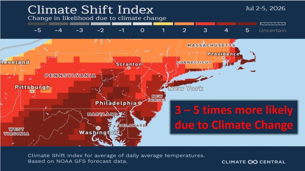
Because of human-caused climate change, this kind of heat from July 2 to July 5 was made about three to five times more likely. That does not mean the heat wave could not have happened without climate change. It means climate change increased the odds.
Think of it like rolling a die. If one side of the die is changed to another six, you can still roll other numbers. But your chances of rolling a six go up.
That is what climate change is doing with extreme heat. It is loading the dice toward hotter weather.
The heat in South Jersey felt more like the desert Southwest. From July 1 to July 5, the average temperature at Atlantic City International Airport was close to what Tucson, Arizona, normally sees during the same time of year.
Along the coast, Atlantic City Marina had temperatures closer to what Honolulu, Hawaii, usually feels in early July.
In other words, New Jersey lived through desert and tropical heat at the same time.
This was not just a hot few days. It was one of the most extreme heat waves on record for the Jersey Shore region.