Category: Uncategorized

  • April Snow at the Jersey Shore: How often does it happen?

    April Snow at the Jersey Shore: How often does it happen?

    By Meteorologist Joe Martucci

    This article appeared in the April 3rd edition of Shore Local Magazine, which you can find here!

    April showers bring May flowers, as the saying goes. But what about April snow showers? Some April snow is common at the Jersey Shore, but don’t expect the plows to pass by the blooming cherry trees.

    Snow is tough to love, especially the older you are. I visited a homeschool group at Lakewood Chapel in Mays Landing on March 26. When I asked who liked snow, most of the children raised their hands, with a few parents agreeing. But most of the parents didn’t like the snow.

    With the arrival of spring, this story plays out often for me, too. April snow especially has a face only Mother Nature could love. (Let me know how you feel about April snow on my social media pages).

    Personally, I love snow until St. Patrick’s Day. Then I’m done with it. However, I could make an exception for record-breaking April snow.

    How often does the Jersey Shore have snow in April?

    For inland parts of the shore counties, 15% of Aprils have had measurable snow, at least 0.1 inches of snow or greater. The most recent time this happened at Atlantic City International Airport was on April 9, 2016. Totals that day, reported via CoCoRaHS, were downright weird.
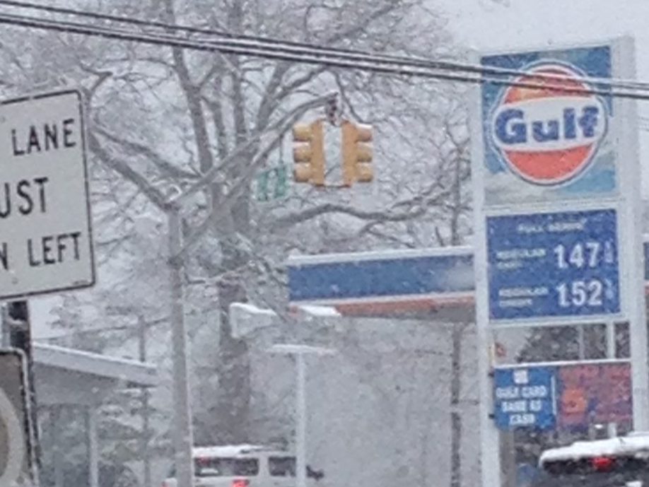
    Snow on April 9, 2016 up the coast in Monmouth County (Via Justin Godynick)

    First, any measurable snow in April is uncommon. But this was a South Jersey snow special. Ocean City reported 3.2 inches of snow. Estell Manor saw up to 2.9 inches of snow, according to the Office of the New Jersey State Climatologist. Central and northern parts of the state barely had accumulation, even on grass.

    Snowfall totals from the April 9, 2016 Snow (Via the Community Collaborative Rain, Hail and Snow Network)

    The Sen. Frank S. Farley Marina in Atlantic City hasn’t kept snow records since 1956. However, looking at the short term, current data in Margate suggests that measurable April snow in the beach towns has a 5-10% chance of occurring in a given year. Longer-term data in Lower Township also supports this probability. For reference, the northern part of the Jersey Shore jumps up to around 20%.

    This all being said, April flurries are common. You can go for a few years in a row with a few festive flakes floating in the spring sky.

    Has it snowed enough to be plowable?

    For the purposes of this question, we’ll assume that 2 inches of snow is plowable.

    Since snow records at Atlantic City Airport began in 1945, there have been only six April days with at least 2 inches of snow or more. In Margate, there has only been one time since records started in 2000 when this has occurred.

    Even in a cooler climate period, the Sen. Frank S. Farley Marina in Atlantic City only had three such days during their 1884-1956 snow record-keeping period. All records come from the National Oceanic and Atmospheric Administration. In other words there has, and continues to be a less than 1% chance the snowplows will come around in any given April at the shore.

    What year produced the most April snow?

    Since measurable April snow is uncommon, and plowable snow is rare, the Aprils with the most snow are largely driven by one day of snow.

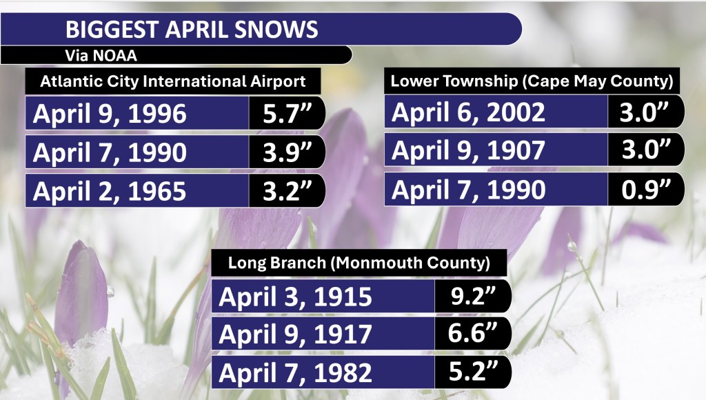
    At ACY Airport, 1996 saw the most April snow – 5.7 inches of snow fell that year. However, all of that fell on April 9.

    Margate’s highest April snow year was 2016 with 2.0 inches. Again, April 9 was the day when all of that fell at once. Another way to look at it is the April with the most days of accumulating snow.

    ACY Airport saw two days of measurable snow in April 1956, 1959 and 1983. Lower Township had two days back in 1907. Meanwhile, Margate only had snow accumulate in April once – in 2016.

    Biggest April snows

    Here’s a look at the three biggest April snow totals up and down the Jersey Shore.

    If you’ve lived in the shore counties your whole life and are over the age of 14, you should remember the 2016 snow.
    May snow?

    The Jersey Shore never had measurable snow in May during its period of record. Non-accumulating flurries are uncommon, but not rare. I remember when flurries flew on Mother’s Day weekend back in 2020.

    Hurricane season forecasts

    On the completely opposite side of the weather spectrum, the first hurricane season forecasts will come out this month.

    It kicks off on April 3 when Colorado State University releases its outlook for the season. Despite the state being landlocked, it was home to William Gray, widely considered the pioneer of this specialized weather field.

    The Weather Channel typically releases its hurricane forecast during the first half of April. So, be on the lookout for that.

    Then, the National Hurricane Center will release its forecast in late May. The Hurricane Center manages all tropical watches, warnings and storm-specific forecasts in the United States.

    As we go deeper into spring, stay tuned for a few hurricane-related articles here.

  • NJ’s drought improves but path to drought-free will get tougher

    NJ’s drought improves but path to drought-free will get tougher

    By Meteorologist Joe Martucci

    This article ran in Shore Local Magazine on March 27th. The original article had data through March 21 (read here). However, this version is updated to the 27th.

    Mother Nature has made up for lost time, bringing plentiful rain to the state since March 5. That’s led to three consecutive weeks of improved drought status, according to the United States Drought Monitor.

    The improved status is clearly visible in the latest update (dated March 20) from the United States Drought Monitor.

    From New Year’s Day through March 4, 3.81 inches of rain fell at Atlantic City International Airport in Egg Harbor Township. The report came from the National Oceanic and Atmospheric Administration. From March 5 until March 21, 5.55 inches of precipitation fell.

    The Sen. Frank S. Farley State Marina in Atlantic City saw a similar increase, recording 5.21 inches of precipitation March 5-21. Before that, it was 3.44 inches since the year began.

    It’s not just Atlantic County. Longtime weather reporting stations in Long Branch (Monmouth County), Trenton (Mercer County), and Philadelphia all saw as much or more precipitation since March 5. This is compared to the previous 64 days of the year.

    The weather pattern favors more storminess through the first week of April. So the shore should continue to see steady or improved drought status. However, improvement for the rest of the spring is considered unlikely. We will say more about that in the moment.

    On March 20 the South Jersey shoreline, from Stafford Township and Long Beach Island on south, improved from extreme drought. This was a level three of four drought. It improved to a severe drought, which is a level two of four. That’s our lowest level since Nov. 5, 2024.

    Inland Atlantic County (west of the Garden State Parkway), was still in extreme drought, though. Those areas join most of Cumberland County, and a small portion of inland Cape May County. This is the only area east of the Mississippi River in significant drought, as my friend and New Jersey State Climatologist Dave Robinson texted me last week.

    Still, New Jersey’s drought is improving. The 7% of the state in extreme drought is the lowest since Oct. 29, when the state was in the midst of its historic driest month on record.

    Drought status between December 10, the peak of the drought, and March 20, in New Jersey (United States Drought Monitor)

    The waning days of March, and the beginning of April bring plenty of opportunities to improve drought even more.

    The Climate Prediction Center, part of NOAA, gives a lean toward wetter conditions around our area through April 4. That’s because the jet stream – the river of air about 30,000 feet high – will be over or around New Jersey during this time. Think of the jet stream as the storm track, with a colder air mass to the north and warmer air mass to the south. This is in part a reaction to the polar vortex entering the Northeast last week, which I talked about on social media if you follow me there.

    We’ll take what we can get. In March, 0.75 inches of rain a week generally keeps us from slipping further into drought. Over an inch, like we’ve seen for most of March, will improve drought’s status.

    However, once we go into April, water usage increases. The sun evaporates more water out of the ground as it goes higher in the sky. We’ll need an inch per week just to keep up, with over 1.25 inches a week to improve drought. These need to be region-wide soakers, too.

    Sure, 3 inches of rain in Linwood from pop-up thunderstorms is great. However, in order for the Kirkwood-Cohansey Aquifer, from which southeastern New Jersey gets its drinking water, and reservoirs for the rest of the state to recharge, we’ll need rain from a coastal storm or a large inland low-pressure system.

    As of March 25, levels in the Manasquan Reservoir were at about 84% of capacity, according to the New Jersey Water Supply Authority. Typically, 97% is the average for March, according to the agency.

    The underlying data still shows there’s work to be done. As of March 23, average stream flows over the past 90 days are still in the “extremely dry” category up and down the Jersey Shore. In the southern part of the shore, it’s been this way for 23-straight weeks.

    I took a deep dive into the Climate Prediction Center’s outlooks. They break it down into three-month periods.

    The way I read it is I should expect a more humid-than-usual summer. That will at least increase the probability of pop-up thunderstorms. That’s good news, but again, we’ll need widespread rainmakers, which are unlikely in our climate once we hit mid-June. Rain storms from tropical cyclones don’t make their way here until late July, usually.

    In a bit of good news, there is a small lean toward wetter weather than usual here. A remnant storm or two would do wonders for us. We failed to get any last fall, which led us into this drought anyway.

    In my opinion, the best case scenario is that drought doesn’t worsen over the next few months. Then we get a tropical cyclone or two to pull us back to normal.

    The worst-case scenario: The extreme drought (level three) expands back to the Jersey Shore. The state would seriously need to consider their first drought emergency since 2002, and the mandatory drought restrictions that come with it, later in the spring.

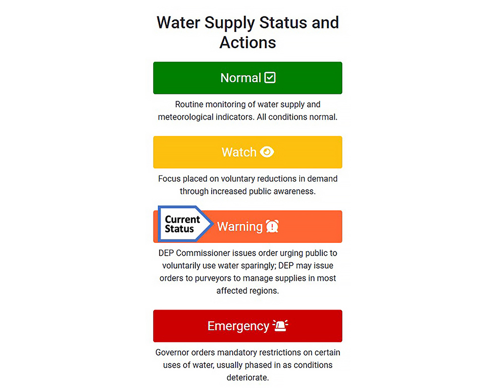
    The NJDEP issued a statewide drought warning last November which called for voluntary water restrictions.

  • We lived through the Jersey Shore’s windiest winter since 2010-2011

    We lived through the Jersey Shore’s windiest winter since 2010-2011

    By Meteorologist Joe Martucci

    This article appeared in Shore Local Magazine on March 20th. Read the story here, also!

    No, it wasn’t just you thinking the wind was howling this winter. This was the windiest winter since 2010-2011, and featured the second highest wind gust on record.

    At Atlantic City International Airport, the average sustained wind speed from December through February (climatological winter) was 9.7 mph, according to the Iowa Environmental Mesonet. During the winter of 2010-2011, that number was 10.3 mph.

    It’s not just the airport. Toms River (8.1 mph) was the windiest since 2010-2011. Meanwhile, Lower Township, at Cape May County Airport, was the breeziest since the winter of 2017-2018 (9.0 mph), according to the Mesonet. The top wind gust all winter was 71 mph at Atlantic City International, which occurred Feb. 16. That was the second strongest gust during climatological winter since records began in 1944.

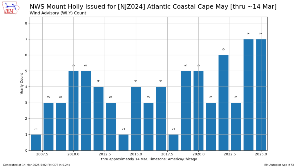
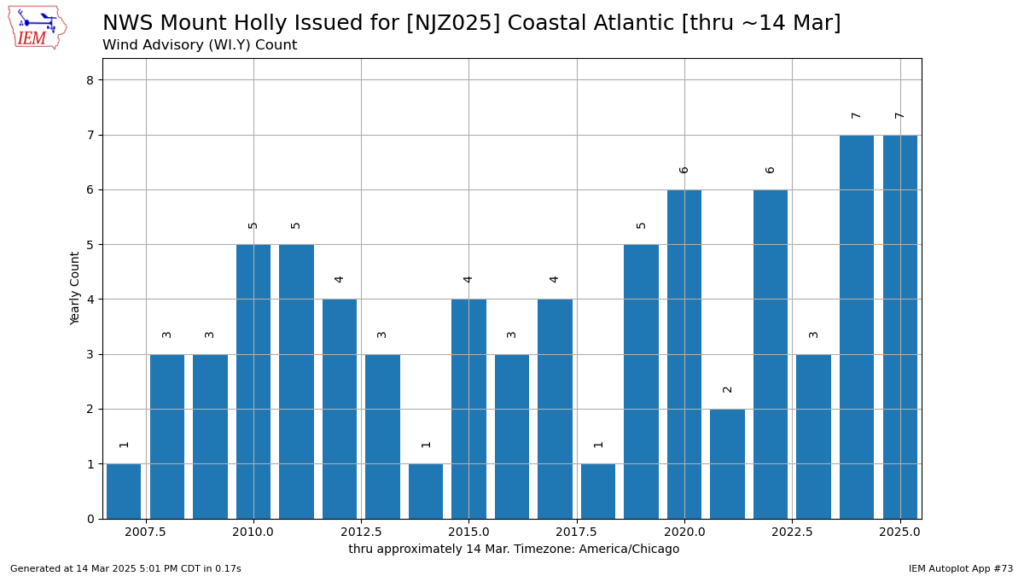
    The breezy weather lasted beyond climatological winter. Atlantic and Cape May counties had the most wind advisories. They either led or tied for the most issued by the National Weather Service this year up to March 14. (A wind advisory is issued when wind gusts are forecast to hit 46 to 57 mph, or steady winds will be 31 to 39 mph).

    The number of wind advisories issued by the National Weather Service for the coastal part of Cape May County (National Weather Service).
    The number of wind advisories issued by the National Weather Service for the coastal part of Atlantic County (National Weather Service).

    Wind speeds this past winter were more significant than in recent years. However, they were still within the normal range for the period of record. Similar to temperature trends, it was ultimately a seasonable winter for wind speeds.

    Since the 1970s, winds have gotten slower at Atlantic City International Airport, according to the Iowa Environmental Mesonet. The winds we felt in the winter of ’24-’25 were calmer than what was normal before the 1980s. Back in the middle of the last century, winter winds usually blew faster than 11 mph. That’s about 20% stronger than the winds we have now.

    A wind speed graph at ACY Airport over time
    Average wind speed, by year, at Atlantic City International Airport (Iowa Environmental Mesonet)

    It’s not just ACY that has lighter winds these days. I checked two other airports with long records. At Monmouth Executive Airport in Wall Township, the winds have been slowing down little by little over the last few decades. But at Millville Municipal Airport, where they started keeping track just a few years after Atlantic City, the winds have dropped significantly since the late 1990s.

    In Millville, the sharp decline can be explained. In 1999, the weather equipment was moved from the eastern side of the airport to its current location on the western side, according to NOAA. There is an area of trees about 350 feet south of there. While they meet the standard practice of being at least 100 feet away from trees, this still likely weakens southerly winds. These winds encounter the anemometer equipment used to measure wind speeds.

    a map of Millville Airport
    The positions of the weather station at Millville Executive Airport. The 3 indicates it’s location up until 1999. It then moved west to its current location, marked by the number 1. (Google)

    At ACY Airport, there’s no clear year in the data that shows the weather equipment moved and caused lower wind speeds. The biggest drop seems to have been in 1978.

    The airport moved its equipment in 1968 and 1995, but the wind speeds didn’t really change much before or after those years. However, there was no location change then, according to NOAA. There was no major equipment change, either. I asked the National Weather Service for an explanation but could not find one. Monmouth Executive Airport’s weather station also doesn’t have any equipment or location explanation for the lower winds.

    There is research supporting the idea. Winds have been getting weaker in recent decades in the Northeast, away from the beach towns.

    “We show that surface wind speeds have declined by 5-15% over almost all continental areas in the northern mid-latitudes, and that strong winds have slowed faster than weak winds,” stated Robert Vautard, research director at the French National Centre for Scientific Research in a 2010 research article. The article looked at the period from 1979 to 2008.

    Vautard argues that a combination of reforestation and urbanization has played a large role in this. To a lesser extent, a weaker jet stream contributed. This jet stream is a river of strong winds about 30,000 feet high that separates two air masses.

    Urbanization makes sense. Atlantic County has grown a lot – 56% more people since 1970, according to the United States Census. Monmouth County, where the executive airport is, grew by 39%.

    The forest idea works, too. Around the late 1970s, when the winds started slowing down, the Pinelands National Reserve was created. This stopped people from building there, so the forest got thicker. Thicker trees block the wind and slow it down. Atlantic City Airport isn’t in the Pinelands, but it’s close enough that it might matter.

    Even so, this winter was pretty windy. There were 11 days when the wind stayed above 15 mph this winter.

    The last time it was windier was back in 1991-1992.

    However, in the 1960s and 1970s winter would have been the calmest season of the whole year. Even in the 2000s, you would consider the season’s breeze average.

    Similar to this past winter’s temperatures, which were the coldest in 10 years, the wind was noteworthy, but in the grand scheme of things, similar to what we used to see. Mother Nature must have had nostalgia for winters past this season.

  • It’s Spring Break: How far south should you go?

    It’s Spring Break: How far south should you go?

    This article initially appeared in Shore Local Magazine on March 13. You can see it here.

    The clocks have turned forward an hour, the buds are on the trees and now, it’s time to pack up and get a glimpse of summer, away from New Jersey. It’s spring break season.

    That may mean a cruise, with dreams of laying on the pool deck with a drink in hand. It may mean cheering on the Philadelphia Phillies at their Spring Training stadium (BayCare Ballpark) in Clearwater (or in my case, Sarasota for the Baltimore Orioles).

    Or, for our college readers, it means a few days you’ll never forget on the beach with your friends, and perhaps your future spouse considering that 1.5 million United States college students travel for spring break annually, according to Michigan State University.

    Count me out, though. The only spring break trip I ever took was north, to Boston, for St. Patrick’s Day.

    On the occasions people tell me they were disappointed in their spring break experience, the weather was to blame: It wasn’t hot enough, it wasn’t dry enough and the water wasn’t comfortable enough.

    So, if and when you decide to pack up and travel south for a spell in March, here’s a look at a few popular destinations and the climate they have to offer.

    Criteria

    For a spring break destination, I’ll assume that you’re looking for a place with average highs between 75 and 85 degrees. You’ll look for places that are largely rain free. Low humidity is a bonus. Mornings should be comfortable – mild enough to stroll around in nothing more than a light layer.

    This is nearly the same criteria I use here at the Jersey Shore for my Shore Summer Weekend Weather Report Card. The data listed below is from the National Oceanic and Atmospheric Administration, unless otherwise specified.

    Myrtle Beach, SC

    “The Golf Capital of the World” is comfortable for golf, but don’t plan on pool or beach time here.

    Afternoon highs in March rise from the low-60s to the upper-60s, on average, as the month goes on. You typically have mornings starting out in the 40s. So, it’s nice. There’s a 31% chance of some rain throughout the month, with a 7% chance of a ruin-your-outdoors-time, half inch of rain.

    Myrtle Beach has a similar climate to New Jersey’s, so in March, expect a fair amount of cloudiness from large-scale storms, like nor’easters.

    Panama City Beach, Fla.

    A classic college spring break destination, Florida’s “Endless Summer” license plate doesn’t extend here. Temperatures are OK for hanging out on the sand. Morning lows start out 50-55 degrees, rising to 70-75 degrees, on average. That being said, there are days where highs will stay in the 60s, even 50s. A solid stretch of very warm weather is unlikely.

    It is drier here, on average, than Myrtle Beach. There’s a 23% chance of rain on any given day in March. However, bigger soakers are more common here than Myrtle Beach.

    Clearwater, Fla.

    Now we’re getting to beach weather, and baseball weather, too. Average morning lows go from the mid-50s at the beginning of the month, to 60 degrees by the end of the month.

    Daytime highs are regularly in the mid to upper-70s; 80s are a homerun at least a few times during the latter half of the month. The weather is nice for watching baseball, and for the sea, 60s occur with some regularity until March 22.

    Rainfall occurs roughly 25% of days in March. Soaking rain over a half inch is uncommon, with a less-than-10% chance each day. Expect lots of sun this time of year.

    Orlando, Fla.

    Spring break with the little ones is extremely comfortable this time of year. Temperatures start out in the 50s during the morning and peak in the upper-70s to around 80 degrees on average. Plus, that swampy, muggy air is still weeks away.

    March is still in the midst of dry season in Central Florida. Like Clearwater, there’s about a 25% chance of rain on any given day. Heavier rains, over a half inch, are uncommon.

    South Florida/Florida Keys

    You can break out those “Endless Summer” Florida license plates here, surfboard in tow.

    Both coasts in South Florida boast average high temperatures in the upper-70s to low-80s in March, rising as the month goes on. The same is true for the Florida Keys.

    Mornings are great for early exercise, or your caffeine boost with friends and family. Lows start out in the low to mid-60s. Similar to Central Florida, most days are without sticky weather, too.

    It’s even drier here than the rest of Florida’s Panhandle. Expect plenty of sunshine in this part of the Sunshine State. From Key Biscayne to Key West, there’s roughly a 20% chance of rain on any given day. Downpours are downright rare.

    Roughly from Jupiter on the East Coast, to Ft. Myers on the West Coast on south is in the Tropical Köppen Climate Zone. That means there’s an average of 64.4 degrees or higher every month of the year, with significant precipitation (at times).

    Daily Chance of Precipitation from February to April for Miami (Red), Clearwater (Green) and Panama City Beach (Purple). Data via WeatherSpark.
    Average March temperature comparison for Florida in Panama City Beach, Clearwater and Miami. Data via WeatherSpark.

    Punta Cana, Dominican Republic

    Our first international destination of the list, Punta Cana is located on the eastern tip of the island nation. It’s firmly in the tropics, meaning March is a beach paradise.

    Morning temperatures start out in the upper-60s to low-70s, with balmy breezes blowing. Afternoon highs reach the mid-80s. It is humid, however it’s not quite the stifling humidity you’ll see later in the year.

    They average seven days with wet weather in March, but soaking rain is rare before March 20. They become more common afterwards.

    Cancun, Mexico

    Perhaps the most notorious spring break spot in North America, Cancun brings the heat during March.

    March temperatures in Cancun are similar to Punta Cana. Mornings start out around 70 degrees and rise to the low and mid-80s during the afternoon, on average, according to WeatherSpark.com. Highs in the 70s and lows in the 60s are common in March, but that’s still fine for time in the water.

    Precipitation occurs three or four days a month, on average. Furthermore, there’s a dip in the number of soaking rains this time of year. It’s rare for long-lasting rain to occur. That being said, it is fairly humid.

    The main difference between Cancun and Punta Cana is the clouds. Average days are cloudy, according to WeatherSpark.com.

    Aruba

    They say Aruba is “one happy island” and with its excellent March weather, it’s easy to see why. With dry conditions, not too much humidity and sunshine, there’s lots of time for the outdoors.

    There’s just a 2-3 percent chance of rainfall on any given day during March, according to WeatherSpark. Cloud cover averages partly sunny during the month, too.

    Temperatures start out in the very balmy upper-70s. Afternoon highs peak in the mid-80s. The humidity is high. However, the island breezes try to mix that out as much as possible.

    Conclusion

    If you’re looking to lay by the beaches, pools and bays for days, you need to be in South Florida, or farther south to enjoy these without worry. However, you can be in Clearwater watching the Phillies or in Orlando and get a stretch of comfortable shorts weather.

    If you are wishing for warmer days but aren’t able to get away for spring break, have no fear; highs reach 75 degrees by March 31, on average, at Atlantic City International Airport, and April 26 at Sen. Frank S. Farley State Marina in Atlantic City.

  • The coldest winter in 10 years just froze N.J.

    The coldest winter in 10 years just froze N.J.

    By Meteorologist Joe Martucci

    This story first appeared in Shore Local magazine on Mar. 6. Read it here!

    Climatological winter – December, January and February – is over, and the latest data shows that this was the coldest since 2014-2015 for the Jersey Shore.

    The average temperature was 34.8 degrees at Atlantic City International Airport in Egg Harbor Township, and 36.4 degrees at the Sen. Frank S. Farley State Marina in Atlantic City.

    What stood out the most to me was how long the cold lasted. December, January and February were all colder than normal, according to the National Oceanic and Atmospheric Administration (NOAA). The only exception was February at the airport, which was exactly average for the season. Note that average here means the 1991-2020 universally used time. We’ll talk more about that later.

    Monthly temperature departure from average

    Here’s the Monthly Temperature Departure from Average in degrees Fahrenheit, according to NOAA:

    December was -1.0 at the airport and -0.9 at the marina.

    January was -3.5 at the airport and -3.7 at the marina.

    February was 0.0 at the airport and -0.2 at the marina.

    It truly felt like a start-to-finish winter at the Jersey Shore. This has become less and less common over the decades.

    While all three months were at or colder than average, that conclusion is based off of the mean temperature from 1991-2020. Looking back at all of recorded history shows that this winter was more in line with an average one than a frigid one.

    Yes it was cold, but…

    Take Atlantic City International Airport. Out of the 82 winters on record, this winter ranked exactly at the halfway point between them all. Taking it a step further, the average temperature for the entire period is 35 degrees, just 0.2 degrees above this past winter’s temperature.

    Go to the beach and we have Atlantic City Marina, one of America’s premiere weather reporting stations. It has had nearly continuous record keeping since 1873 – one of the country’s longest established weather outposts. Plus, situated right at the marina, its data reflects the true impact of the water on the shore’s climate.

    This was in the colder half of the 150 winters on record, but not by much. It was the 68th coldest, putting it in the top 45%. The long-term average is 36.1 degrees, which is actually slightly colder than what we just experienced.

    Neither Atlantic City International Airport nor Atlantic City Marina set any new cold temperature records. The last time either place had record cold, for high or low temperatures, was in 2022, according to the Iowa Environmental Mesonet.

    The only new record was in Estell Manor, Atlantic County. On Feb. 19, the highest temperature of the day was just 30 degrees, the coldest ever for that date. Records there go back to 1966. While it’s not as well-known for climate data as the airport or marina, it still provides useful information.

    Overall, this winter wasn’t extremely cold when looking at all past records. But compared to recent years, it was colder than usual – the coldest since the winter of 2014-2015.

    Frozen waters

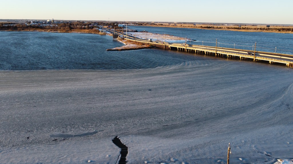
    Ice is visible well off the shore on the Beach Thorofare in Atlantic City during January, just off of West End Avenue. (Photo by Joe Martucci)

    The salty bays had some ice on them from late December to mid-February. In some places, the ice stretched far out into the water.

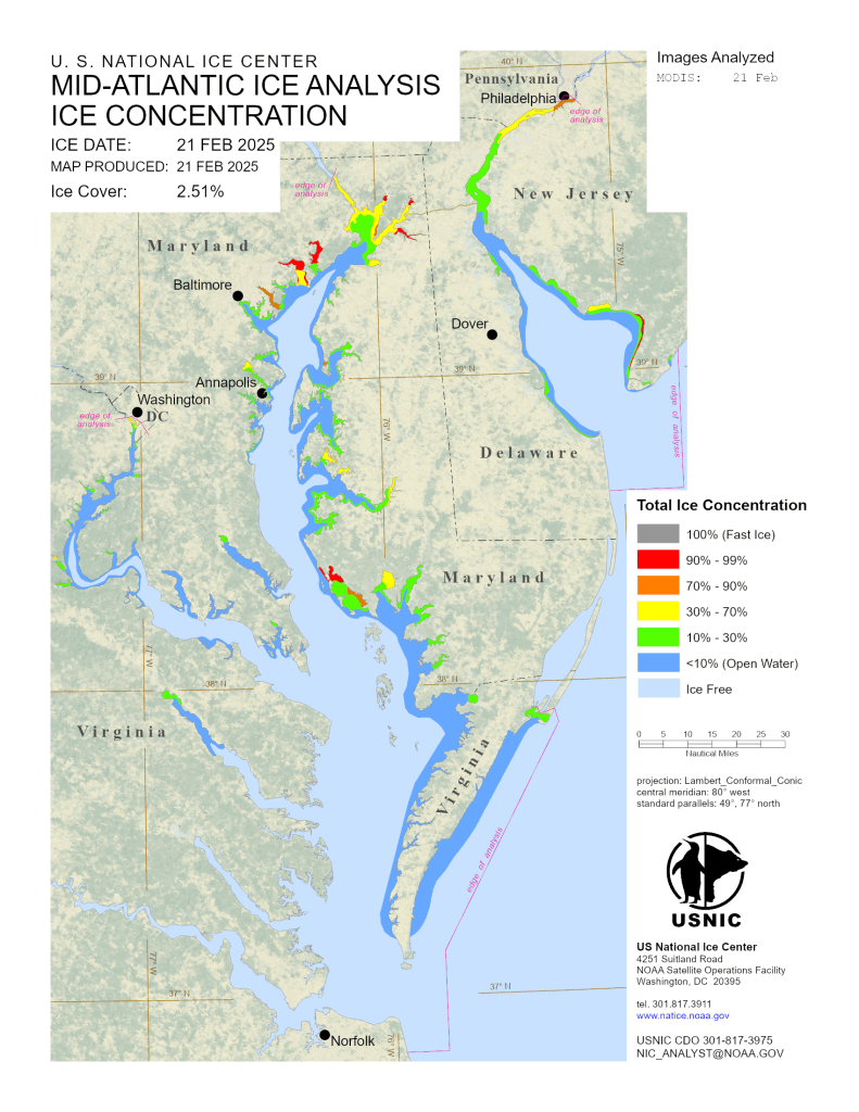
    Ice was especially extensive on Jan. 24. Most of the Delaware Bay had a total ice concentration of 90%, according to the United States National Ice Center. Even on the Atlantic Ocean side, there was some ice in Cape May County.

    The Delaware Bay shoreline, from roughly Del Haven, Middle Township, over to East Point Lighthouse was at least 90% iced over on Feb. 21, according to the United States National Ice Center. At least some ice covered nearly the entire Delaware Bayshore that day, too. That extended up the river to Philadelphia.

    The freshwater ponds were frozen over for a long while this winter. Pictures on social media of people playing pond hockey, skating or even ice sailing were seen up and down the Jersey Shore. Furthermore, the cold reversed the trend of plants and trees budding in mid to late February.

    Why was it so cold?

    The reason for the coldest winter in nearly a decade has to do with two factors: the polar vortex and the cold ocean.

    The polar vortex is a cold dome of low pressure in the stratosphere. It sits over the poles in its resting state. This winter, it stretched down into the northern United States numerous times. As of the end of the month, it occurred 10 times, according to Judah Cohen of Atmospheric and Environmental Research (AER) in Massachusetts. For those keeping score at home, that’s a lot.

    When that happens the jet stream – the river of air about 30,000 feet high that separates colder and warmer air masses – will dive toward the equator about 10 to 14 days after the polar vortex moves in.

    The polar vortex and jet stream can stretch down to the equator anywhere in the Northern Hemisphere it wants. However, this winter, it was locked into the northern tier of the United States, as well as far eastern Russia.

    Typically, stretched polar vortexes bring less bitter cold than a split polar vortex (when the polar vortex breaks into two). However, with it occurring 10 times it brought a persistent cold.

    The second thing that affected the weather was the cold ocean. It made the air chilly at the Jersey Shore. The Atlantic City Marina was much colder than usual compared to Atlantic City International Airport.

    The ocean water was colder than normal this winter. It was 45 degrees in December, 40 degrees in January, and 39 degrees in February, says the National Oceanic and Atmospheric Administration. Also, the bays were super cold, even below 32 degrees for a while.

    The drought continues

    In addition to temperatures, we have to talk about precipitation. We did not get the rain or snow needed to pull us out of drought. In fact, in my winter outlook I said the following:

    “There should also be an average amount of storminess… Drought should recede during the winter, but I don’t believe it’ll be enough to cure our problems as we exit the season. Looking ahead, we’ll need a wetter-than-average spring to end the drought for good. Otherwise, there will be water problems.”

    That was true for New Jersey as a whole. However, for the South Jersey Shore, “extreme drought” lasted all winter long, according to the United States Drought Monitor. That’s the third level with level four being the worst. Statewide, most of the northern half of the state dropped from level two to level one for drought. This change occurred by the Feb. 27 update.

    Precipitation over the three months was between 6.18 inches at Atlantic City Marina and 8.70 inches in Galloway. This is for Atlantic and Cape May counties based on data from the National Oceanic and Atmospheric Administration. That’s 26% to 50% below average.

    Snowfall ranged from a little below average in Atlantic County to a little above average in Cape May County. Margate was the lowest at 10.3 inches. Lower Township was the highest at 17.5 inches. I’ll have a full snow season recap later in the month.

    Looking ahead

    March does not look like a very wintry month. After the frigid cold on March 2-3, temperatures will mostly be at or above average. This trend is expected through the middle of the month. Think highs in the 50s and 60s, cooler at the beaches as the daily, chilling sea breezes return.

    Cohen from AER believes one more shot of colder-than-average temperatures will arrive in the second half of March. If it does, we’re likely talking highs in the 40s and lows in the 20s. That’s more of the typical wintertime cold, nothing exceptional.

    In terms of precipitation, there’s no strong lean toward a wetter- or drier-than-average month. Getting a normal amount of rain would be helpful. March is the wettest month of the year at Atlantic City Marina with 4.27 inches of rain. It’s the second-wettest month at Atlantic City International Airport, with 4.52 inches. That much rain would stop the drought from getting worse, but it wouldn’t make it better.

    By St. Patrick’s Day, we’ll need about an inch of rain each week. This is necessary to make up for the water that dries up from the ground. It’s also for the water that people use. To get ahead, we would need at least 1.25 inches a week.

  • Understanding Snow Forecasts: Meteorology vs. Weather Apps

    Understanding Snow Forecasts: Meteorology vs. Weather Apps

    Originally appearing on Shore Local News on Feb. 27. Visit my friends at Shore Local here!

    By Meteorologist Joe Martucci

    Five to seven days before the New Jersey nor’easter that never was on Feb. 20, I received many messages about it. Here’s three examples (edited for clarity):

    “How much snow are we getting Thursday? People in school are saying 15 inches.”

    “Joe, are we really supposed to get over a foot of snow on Thursday? Apple Weather told me.”

    “Someone said we are getting 15-18 inches of snow…”

    What happened last Thursday? Snowy coatings south of the Cape May Canal with a gentle breeze out of the northeast.

    These three messages were like dozens of others. Messages, comments, and posts to me all circled around the same concept: the generic weather phone app. Using it is fine 75% of the time. However, just like calling a 1-800 number, when you really need an answer, you want a human to help you out.

    This doesn’t mean the nor’easter didn’t happen at all. Norfolk, Va. reported 11 inches of snow, Chincoteague Island, Va. off the Delmarva Peninsula reported 6.5 inches, and the Outer Banks of North Carolina reported 3 to 6 inches of snow according to the National Weather Service.

    Visible satellite over the Mid-Atlantic after the Feb. 19-20, 2025 nor’easter. Note the bright white in eastern Virginia and North Carolina. That is snow cover. New Jersey, meanwhile, had none (NOAA).

    I, and every credible meteorologist I know of in the area, did not start putting out snow forecasts until Monday. That’s about 60 hours before any storm was supposed to come. My forecast, even on Monday, was for a lower impact event. No foot-plus forecasts or historic nor’easter for New Jersey.

    Now this is not because we meteorologists hunkered down in a basement and all decided to withhold the snow forecast from you. It’s because we know how nor’easters work and the limitations of computer modeling.

    Think about this: Meteorologists have to be accurate because they work for the public or their bosses. Phone apps? Not so much. They’re made by companies to make money, not to help people. They just spit out computer guesses with no real risk. That’s why an app might say a foot of snow one day, then an inch the next, and then 6 inches after that.

    Meteorologists, like the ones who work for the government or news outlets, are usually seen as people you can trust.

    A long time ago, our job started because we wanted to keep people safe. When we say it’s going to snow, most folks believe us more than their phone apps. Our weather predictions help people get ready for big storms – like knowing when to leave their homes or stock up on supplies. Take Superstorm Sandy, for example. People listened to us to figure out what to do, not just some computer message.

    Generic phone apps are quick, easy and give you an answer. That’s what we all want in life. I want that in life, too. But as they say, life is not always black or white. It’s just not that easy.

    The reason I waited until Monday to issue a snow forecast was because of computer model limitations and an understanding of how the atmosphere works.

    Weather predictions past 84 hours use global models. These models cover the whole Earth, about 12,430 miles from pole to pole. The distance from Ocean City, NJ, to Norfolk, Va., is just 1.5% of that, so it’s tiny compared to the model.

    Therefore, on Feb. 13, 14, 15 and even 16, it was fair to say that a nor’easter would be around New Jersey on Feb. 20. However, it would have been impossible to pinpoint a snow forecast. Even if the generic weather app were right it would have been pure luck – like throwing a dart in the bullseye blindfolded.

    Secondly, the nor’easter didn’t enter the United States’ West Coast until Sunday night to early Monday. That plays a role. When it enters the country, it can be sampled by the National Weather Service’s twice-daily weather balloon launches for weather data. That data then feeds into the weather computer models.

    Third was that there was going to be plenty of dry air to the north. This was always going to bring a sharp cutoff in snowfall totals. It was why I thought our third “South Jersey Snow Special” was a good possibility on Monday, despite it not working out that way. But again, when the snow map first came out Monday, the highest snowfall forecast was 1.5 to 3 inches of snow for Atlantic and Cape May counties. Places like Medford and Trenton would see no accumulating snow.

    The reality is that 75% of the time, using your generic phone app is fine. If it’s dry, it won’t really matter to us if it’s sunny, or partly sunny, or if it’s 65 degrees or 68 degrees. I get that.

    However, when the specifics of the forecast really matter, that’s when a meteorologist comes in. I used to work at the weather consulting company WeatherWorks in Hackettstown. We worked with movie production companies. They needed accurate cloud cover forecasts. A phone app can’t do that. A meteorologist can.

    The same goes for snow, hurricanes and coastal flooding. It’s going to take longer to get an answer from us than the phone app, but it has a better chance of being the right answer, and giving you the context you need. That’s why many of us still check in with meteorologists daily, even if the next week will be mild and clear.

    Last week I had to call the Internal Revenue Service for something. After dialing the number, I pressed one automated prompt, then another automated prompt that I thought would help me out. It left me without the answer I needed and once the automated prompt ended, the call ended.

    After a few tries of different combinations, I reached a very pleasant man in West Virginia. I explained my problem and he helped me out right away.

    Human knowledge and context, aren’t going away soon.

  • South Jersey: The Unexpected Snow Capital of NJ

    South Jersey: The Unexpected Snow Capital of NJ

    Read the Feb. 20 article in Shore Local News here!

    NOTE: This article came out on Feb. 20 but was written on Feb. 14. As we know, there was no snowy nor’easter in New Jersey this week. That stayed in Virginia. This article is modified to adjust for that.

    With two South Jersey Snow Specials down and another one possibly on the way, our area could beat out the typically snowy, hilly northwest New Jersey for the snowiest place in the Garden State.

    As of this writing, we didn’t know what would happen with a nor’easter anticipated on Feb. 20, but it turns out it brought a record snow to southeastern Virginia. Meanwhile, only Cape May City saw coatings. There was no third South Jersey Snow Special.

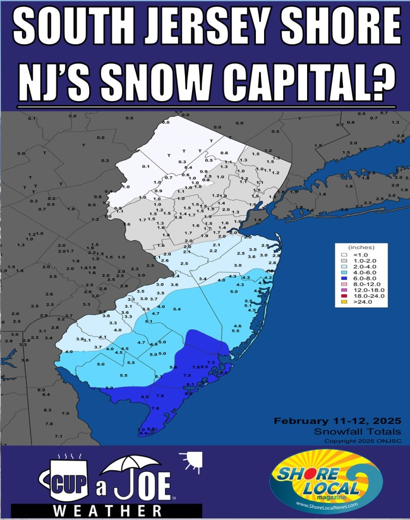
    However, Jan. 6 saw Wildwood Crest’s 8-inch report as the highest snowfall total in the state. 4 to 6 inches of snow fell in places like Ocean City, Somers Point and Margate, too. Meanwhile, once you went north of the White Horse Pike, snowfall totals were generally below 2 inches.

    Then, on Feb. 11-12, it happened again. In an all-snow event, Cape May was in the top spot with 8.8 inches of snow. However, more than 6 inches of snow fell in eastern Atlantic County, as well as all of Cape May County; 8.1 inches were measured by Dan Forshaw in Somers Point, a volunteer weather observer for the Community Collaborative Rain, Hail and Snow Network (CoCoRaHS). In Ocean County, 6 inches fell as reported by another CoCoRaHS spotter.

    It’s rare for the southeastern part of New Jersey to get more snow than the usually snowier and colder northern areas of the state.

    Since the winter of 1939-1940, there have been eight times when either the Cape May area or Atlantic City International Airport got more snow than other major weather stations in New Jersey. These other stations are: Trenton, New Brunswick, Newark, and Belvidere. This information comes from the National Oceanic and Atmospheric Administration, or NOAA.

    Here’s a look at those winters, along with the location of the snowiest place and how much snow they received. All data are measured in inches.

    1939-1940: Cape May area, 28.1.

    1967-1968: AC Airport, 18.5.

    1978-1979: AC Airport, 43.1.

    1988-1989: Cape May (Lower Twp.), 21.2.

    1989-1990: AC Airport, 23.0.

    2009-2010: AC Airport, 58.1.

    2021-2022: AC Airport, 33.3.

    2024-2025 (thru Feb. 15); AC Airport, 13.8.

    If it happened before, then this winter has the possibility of doing it again.

    There are specific reasons why each winter had more snow here than the rest of the state. They can be grouped into a few categories.

    This winter, just like in 2009-2010 and 1988-1989, the storms that make snow are coming from so far south that our area is getting the most of the snow in New Jersey. When you go north, you get too far from where the storms are so places like Belvidere or Newark didn’t get much snow because it was too dry there.

    The winter of 2021-2022 had that as well. A storm on Jan. 3, 2022 brought over 8 inches of snow to the South Jersey shore. Meanwhile, north of Interstate 195, there was no measurable snow.

    However, later in the month, the Blizzard of 2022 happened on Jan. 28-29. The storm track was so far east that the Jersey Shore saw the most precipitation. Twelve to 20 inches of snow fell here, but Atlantic City International Airport only picked up 16 inches of snow. Meanwhile, Trenton and Belvidere saw less than half of that.

    Some were just luck. The winters of 1967-1968, 1978-1979, and 1989-1990 all saw about the same amount of snow throughout the state. However, Atlantic City International Airport or the Cape May area saw just a little more than the others.

    We need to wait and see how much snow we get from the anticipated Feb. 20 nor’easter. I think it’s possible for the South Jersey shore to get more snow than other parts of New Jersey this winter. However, we’ll need one more South Jersey Snow Special to do so.

    Temperatures are expected to be colder than average for our area from Feb. 22 through the middle of March, according to NOAA’s Climate Prediction Center. While that doesn’t guarantee snow, that’s a help.

    On the other hand, the forecasts for the upper-level weather pattern suggest that winter storms will take a more northerly track. It could be that when it’s cold enough for snow, it’s dry, or when a storm arrives, it warms up. That would mean less snow here compared to climatologically snowier spots farther north in the state.

    Plus, as we deal with every year, our snow season is just shorter. Our average last measurable snow in Lower Township is March 2, according to NOAA. At Atlantic City International Airport the average is March 6. Trenton, Newark and Belvidere’s are all at least 12 days later. That gives these locations a longer runway to make up their snow deficit.

    Ultimately, we are progressing well to once again create history in this region of the Garden State, but assistance will be required to achieve this goal.

    If you have a small open space on your property and like weather, please consider joining CoCoRaHS. See https://www.cocorahs.org/application.aspx

    Joe Martucci, a Certified Broadcast Meteorologist and Digital Meteorologist, is the President and Director of Meteorology for Cup A Joe Weather and Drone. You can connect with him at cupajoe.live/.

  • New Jersey’s Dry January: Drought Impact Explained

    New Jersey’s Dry January: Drought Impact Explained

    By Meteorologist Joe Martucci

    Dry January, the annual ritual in which people refrain from drinking alcohol to kick off the new year, extended to Mother Nature as well. However, in her case, the dry January wasn’t about a lack of alcohol, but a lack of precipitation, significantly lowering the chances that we will end the drought by the time spring comes.

    Dry on the coast

    New Jersey’s Precipitation Departure from Jan. 1 to Feb. 6 (NOAA)

    The Coastal Region of New Jersey, roughly anywhere from the Garden State Parkway on east, including most of Cape May County, had the third or fourth driest January on record, according to the Office of the New Jersey State Climatologist.

    Records going back to 1895 show it was among the driest 2-3% of Januarys on record, according to Dave Robinson, the New Jersey state climatologist.

    Snow not enough

    Don’t be fooled by the snow cover on the ground, the cold weather and lack of watering you did in January. This is bad news for New Jersey.

    Every week, January saw either an improvement or no change in its drought status, which is updated by the United States Drought Monitor on Thursdays using data through that Tuesday. That is, on Jan. 30, 15% of the state worsened from a “moderate” drought – a level one of four for drought – to a “severe” drought, a level two.

    The South Jersey shore remained in the driest condition, located in an “extreme” drought at level three of four. More than a third of the state, 34%, is in this classification, which includes all of Cape May and Atlantic counties, as well as most of Cumberland, Burlington and Ocean counties. Our region has remained in this extreme drought from Nov. 12 through the Jan. 30 update.

    While our Feb. 5 status is not known at the time of this writing, there’s no reason to believe our drought status will be better by then. We need around 0.75 inches of rain a week just to stay steady, and more to improve our status. We’re not expected to go much above 0.75 inches by the Thursday update.

    I’ve been saying since our winter forecast was released on Nov. 27 that we won’t have enough precipitation to cure drought by the time the winter season is over. Sadly, that’s proving true.

    Spring is coming

    We have about six more weeks to improve drought fairly easily. Water usage is at an annual minimum and the sun isn’t evaporating much moisture from the ground.

    But six weeks from now it will be late March. Water usage will increase as agriculture begins and sprinkler systems come back online. The sun will be stronger and pull moisture out of the ground through evaporation. By this point, we’ll need about an inch of precipitation a week just to keep our drought status steady, and probably 1.5 inches a week to improve drought. That’s a tall order.

    The Climate Prediction Center forecasts equal chances of precipitation being either below average, near average or above average for February from their mid-January update. Those equal chances extend to their three-month outlook, which covers February through April.

    Sure, it’s possible we wind up on the wet side, but don’t place your bets on it. Even average precipitation during this time will bring harm to the state, let alone below average.

    Forest fire danger

    Prescribed burning will be a challenge to meet the New Jersey Forest Fire Service’s mission to protect “life, property as well as the state’s natural resources from wildfire.” Prescribed burning reduces the risk of future wildfires by skillfully applying fire to reduce the underbrush, which is fire fuel. Typically, this begins in late February and continues through spring.

    Most of the Pine Barrens range from a level five to a level nine out of 10 when it comes to burn probability, as of Jan. 31. I expect that to worsen in the next few weeks.

    If conditions are too dry, it’s hard to conduct prescribed burning, and even skillfully applied fires can spread rapidly. Reduced prescribed burning just means a greater likelihood the inevitable wildfires that do occur this year will be bigger and spread faster.

    Dry streams and wells

    Many of us have well water once you go offshore. With groundwater conditions running “extremely dry,” according to the New Jersey Department of Environmental Protection (NJDEP), expect this to mean either your well will need to be dug deeper, or risk going dry completely and relying on outside sources of water.

    Streamflows have also been suffering under the extremely dry conditions for the past 14 weeks, the NJDEP says. That will impact the amount of oxygen fish and other freshwater marine wildfire can consume. Expect impacts there.

    Water restrictions

    Via the New Jersey Department of Environmental Protection

    This one is a policy decision. I’m not a policymaker, nor do I know everything that goes into the decision. However, currently the state is in a drought warning. The next step would be a drought emergency. The last time that occurred was from March of 2002 until January of 2003, according to the state.

    The current drought is as significant and severe as it was then, so it’s very possible that we will go into an emergency this spring if drought conditions don’t improve. We already have volunteer water restrictions in effect by New Jersey American Water. A drought emergency doesn’t have to mean water restrictions statewide, but in the 2002-2003 emergency it did.

    On June 20, 2002, the state issued mandatory restrictions. They halted commercial power washers, of flushing sewer systems, and mandated odd/even days for watering lawns. Restaurants were told not to serve water unless requested by customers.

    I can’t say for sure, but I bet that kind of restriction will take place if precipitation winds up at or below average over the next three months.

  • Ice is at the Jersey Shore. Here’s how to enjoy safely.

    Ice is at the Jersey Shore. Here’s how to enjoy safely.

    Read it on Shore Local News here!

    By Meteorologist Joe Martucci

    The Jersey Shore has had more ice the past two weeks than at any point since December 2017 – January 2018. More seasonable temperatures this week melted some of that, but a full thaw won’t come soon. That gives us opportunities to enjoy the ice, as long as we keep some important safety tips in mind.

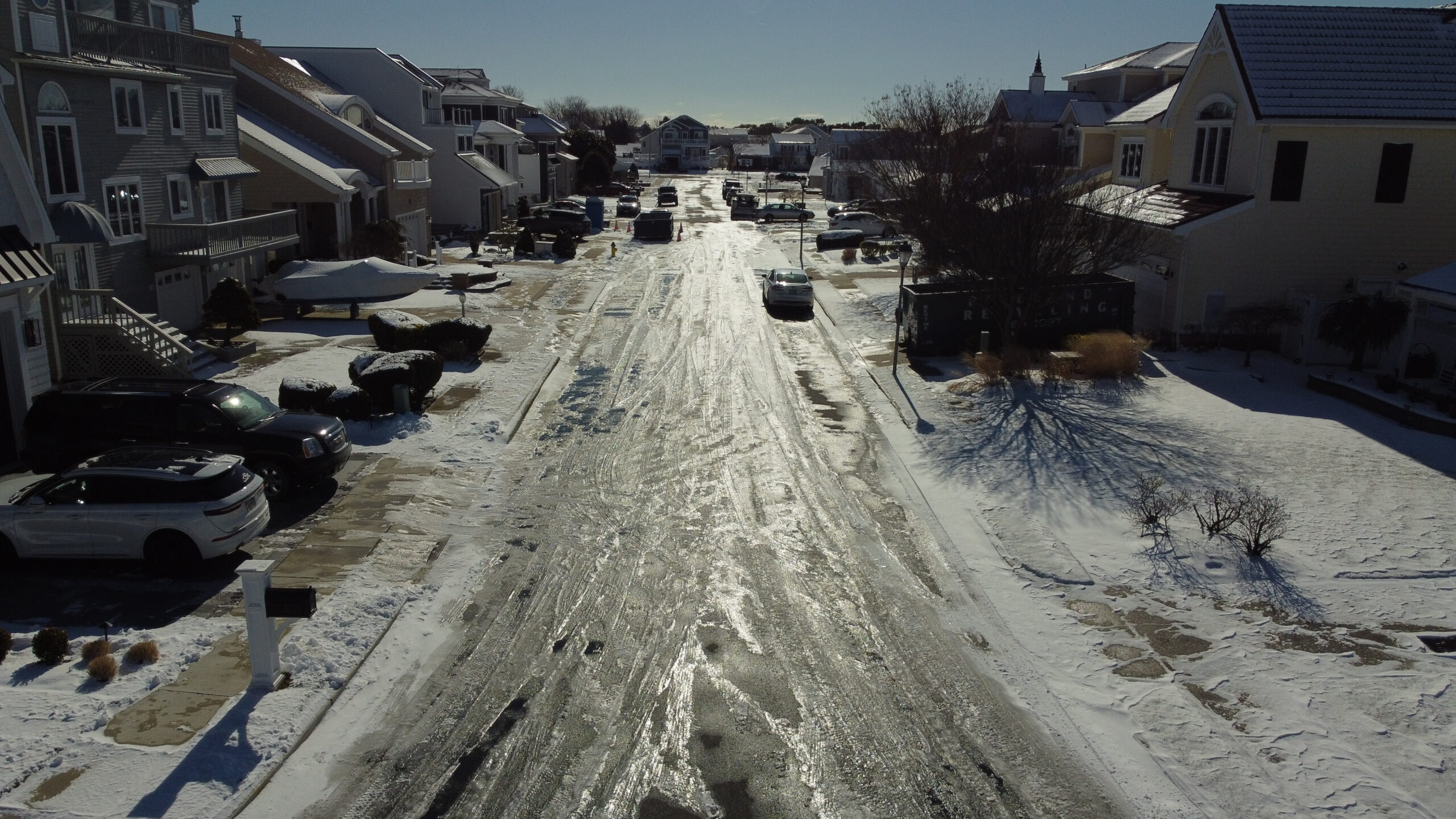
    Once Jan. 4 came, most of our days were spent below freezing. Ice first developed on the freshwater ponds in the first week of January. By Jan. 9, ice had formed on the edges of the saltwater back bays. I captured drone footage of ice on Beach Thorofare in Atlantic City, right off West End Avenue.

    That stayed more or less the same for a while. However, the arctic outbreak last week, caused by the polar vortex, expanded the ice deeper into the back bays. Big bays like the Barnegat and the Delaware, formed ice on them as well.

    Ice provides our cold, barren, Jersey Shore winter with opportunities for outdoor activities. Pond hockey, ice fishing, even just walking on the ice far away from the beaches, give us unique opportunities to enjoy our beautiful environment in a different way. However, especially in salt and tidal water, safety is paramount.

    The first step, before setting foot on the ice, is to check with your local police or fire department about ice conditions. Call their non-emergency phone number. They may even post about it on their website or social media as well.

    Photo credit: Whateveraclife Gaming

    As part of the ice report, they should list how thick the ice is. That’s important. What you can do out on the ice is determined by how thick the ice is.

    Put simply, anything below 4 inches of ice is too thin to be out on. Even your own body weight is too heavy to be supported on that ice.

    For walking, ice fishing or ice skating, ice at least 4 inches thick is mandatory, according to the Minnesota Department of Natural Resources, although if you and three friends are sitting close together ice fishing, that 4-inch ice thickness guidance is not enough, either.

    If you’re itching to take your all-terrain vehicle from the dirt roads to the ice roads, you’ll need at least 7 inches of ice to do it safely. You would struggle to find ice that thick around here. Just for reference, if you want to take a car out, you need at least 9 inches of ice.

    That’s only on new, clear ice. If snow melts then freezes on the ice to create what is called white ice, then the ice is half as strong, which means the recommended thickness should be doubled.

    For rivers, streams and especially bays, the moving water creates uneven ice. But there are ways to even out the area you’re going to utilize on the ice.

    When I used to play hockey on the Rahway River in Union County growing up, we had a pump that would throw water on the ice the day before to smooth over the bumps for the next day’s use. You don’t want to catch an edge and send yourself down to the surface.

    If you must measure the ice yourself, you’ll want an ice auger. That’s a tool with a circular, swirling shaft which, depending on the design, can be used manually or mounted to a drill to easily cut through ice. Make sure you’re standing straight up and then drill straight down. Lift it up once you cut through the ice. Then, with a tape measure, determine the thickness.

    There’s plenty of safety factors to take into consideration, but once you’re out on the ice, there’s almost nothing like it. Breathing in the icy, dry air can be invigorating. And, for a region that is tied to the water, being able to enjoy it when beach season seems far, far away is a joy.

  • Snow and bitter cold grip the Jersey Shore in January

    Snow and bitter cold grip the Jersey Shore in January

    Read it on Shore Local News here also!

    A little snow this past Sunday kicked off a week’s worth of well-below-average temperatures, which we will only get out of this Sunday.

    A coastal storm impacted the Mid-Atlantic on Sunday. This wasn’t a strong coastal storm. There was no coastal flooding, and the winds weren’t all that strong.

    However, it was still a low-pressure system that moved from the Deep South around Virginia Beach, and then just off the Nantucket coast.

    Snowfall totals at the South Jersey Shore were light. Just 0.3 inches fell in Somers Point, and a trace was reported in Ocean City.

    It snowed for several hours Sunday. However, temperatures were above freezing most of the time, which meant much of that snow melted on contact with the ground instead of accumulating.

    Other parts of the state picked up more snow. Western Atlantic County saw 1 to 2 inches, and Northern Ocean County saw about that as well with northwest New Jersey seeing 4 to 8 inches.

    I mentioned in my forecast that what happens after the storm would be more impactful than what happens during it, and surely came true.

    Temperatures crashed into the 20s, turning wet pavements and sidewalks into sheets of ice. That ice still hasn’t melted in spots as temperatures stayed below freezing Monday, Tuesday and Wednesday. At the time of this writing, it looks like temperatures were not going to go above freezing until Friday inland, perhaps just peaking at 33 degrees in the beach towns Thursday.

    Either way, it’s been frigid. Atlantic City International Airport had a high temperature of 29 degrees Monday. On Tuesday, both ACY Airport and Sen. Frank S. Farley State Marina reached just 20 degrees for the high.

    Tuesday was the coldest day since Dec. 24, 2022. It was 21-23 degrees below average – as cold as a typical Jan. 21 day in Caribou, Maine, in the far northern reaches of our northernmost state.

    Morning lows were very cold as well. However, without a snowpack to accelerate the cooling at night, it hasn’t been exceptional. Lows generally remained 7-12 degrees inland, and 10-15 degrees at the shore.

    This polar plunge was the result of the polar vortex. About two weeks ago, the polar vortex in the stratosphere, which is 8 to 31 miles above the surface, entered the Northeast, causing the jet stream in the troposphere, which is about 20,000 to 30,000 feet high, to become very wavy, moving in a more south-to-north fashion. The jet stream is the river of air that separates two air masses. In this case, it was mild air to the south and true polar air to the north.

    Once Sunday’s storm passed, that jet stream dipped down into the Gulf Coast. Since we’re far north of that, we had a near uninterrupted path to the polar air.

    Now as cold as it’s been, we didn’t break any cold temperature records. At the Atlantic City Marina, we needed to have highs in the 10s, with lows in the lower single digits. At Atlantic City International Airport, the lows needed to be below zero.

    Getting below zero is tough and getting tougher. The last time the airport was below zero was Jan. 7, 2018, according to the National Oceanic and Atmospheric Administration. It’s been three years since we last set a minimum daily temperature record. However, we’ve set roughly two dozen maximum temperature records since.

    The bitter cold will end this weekend. Temperatures will rise to seasonable levels Sunday, with highs in the 40s. It will feel like New Orleans compared to where we’ve been. However, maybe I’m speaking too soon, since that city just saw its biggest snowfall in recorded history on Tuesday.