
It’s been one of the coldest starts to December on record at the Jersey Shore. However, a thaw is here, leaving our chances of a white Christmas at near zero.
This article first appeared in Shore Local News on Dec. 18
The Climate Prediction Centerhttps://www.cpc.ncep.noaa.gov/, part of the National Oceanic and Atmospheric Administration (NOAA) is leaning toward above average temperatures for the days around Dec. 25. It’s not just here either. The center is leaning toward most of the Lower 48 being milder than average, with the best chances of warmth in the Deep South and Southern Rocky Mountains.

I know some of us can’t stand the snow, but I believe most of us agree that snow during the holidays is nice to see, for at least a little bit. But our frigid weather came too early.
At Atlantic City International Airport, the likelihood of an official white Christmas — at least 1 inch of snow on the ground — is 6%. There’s also a 6% chance of any snow at all falling on Christmas.
Farther south, Lower Township has a 5% chance of a “technical” white Christmas, with the probability of snow falling on Dec. 25 at 3%.
Up the coast is where the best chance of a Jersey Shore white Christmas can be found. Long Branch has a 15% chance of at least 1 inch of snow on the ground, and a 7% chance that Dec. 25 will have at least some snowfall throughout the holiday.
Our last official white Christmas at the Jersey Shore was in 2009. Do you remember that one? I was a freshman at Rutgers University then. I still remember waking up at my parents’ house in Central Jersey and seeing how bright Christmas morning was with the sun reflecting off the snow.
We got darn close last year, though. A cold front brought snow showers on Dec. 24, 2024. However, only a trace, or unmeasurable amount of snow was recorded. Your grass or car may have been dusted with snow, but Christmas Day, it was gone.
The big feature in our weather forecast next week will be a thicker-than-usual atmosphere over the Northeast. Called a ridge, this thicker atmosphere can hold more heat in. On the surface, high pressure should more or less hang out near Bermuda. That means a milder wind out of the south most days, including Christmas.
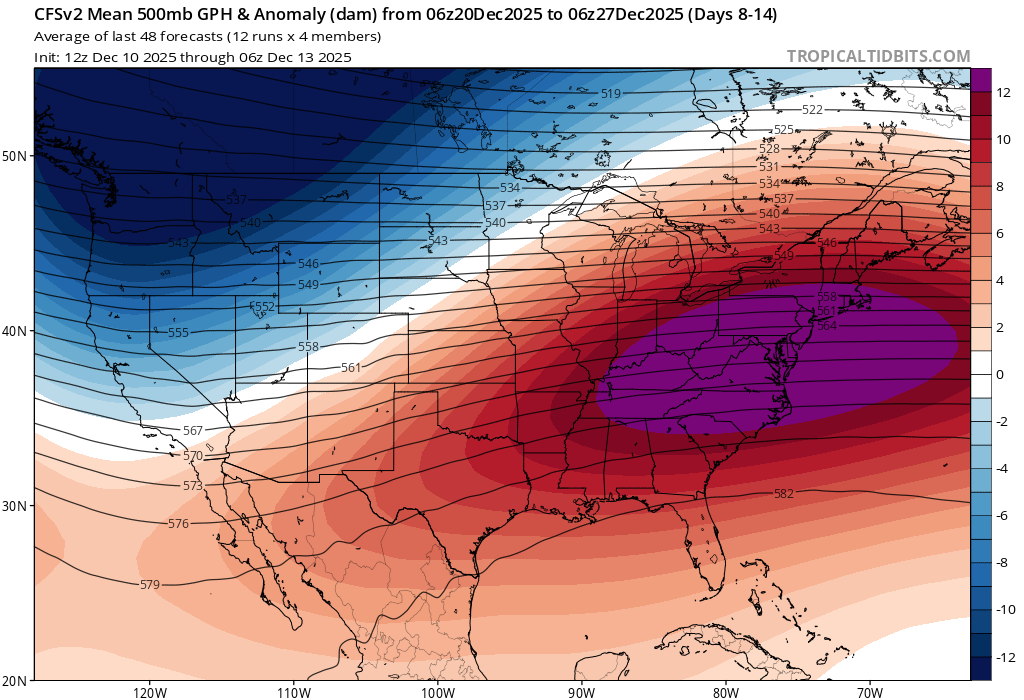
While winter time Bermuda highs don’t bring hazy, hot and humid weather like they do during the summer, they do keep the Snow Miser out.
Highs around 50 degrees seem like a good bet to make as I write this 7 day before the holiday. I feel pretty confident that the beaches will be above freezing Christmas morning, too. A little precipitation is possible but this would very much likely be rain, not snow.
We’ll take it, the New Jersey Department of Environmental Protection has us in a drought warning – but anything that does fall wouldn’t ruin travel plans, though.
Traveling across the United States next week looks fairly good, too.
Then, a round of snow, caused by an atmospheric river slamming into the West Coast, will pass through northern California and the Pacific Northwest Dec. 21-22. It then moves through the most northern tier of states as snow. That means Montana, North Dakota, northern Minnesota, Wisconsin and northern Michigan are the areas that would see snow.
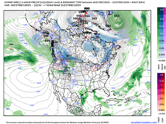
Those airports can manage this kind of snow, though. If you’re going there next week, that’s awesome. I’d like to check out those areas.
If you like the thaw, I have good news. The polar vortex should be back at its home at the North Pole through the end of the month, at least. So, a long-lasting cold shot like we just had early in the month, won’t happen again until mid-January at the earliest.
Joe Martucci, a certified broadcast meteorologist and digital meteorologist, is also the president and director of meteorology for Cup A Joe Weather and Drone. You can connect with him at www.cupajoe.live.
Leave a Reply