7 to 9 rounds of tidal flooding are possible through Sunday.
Beach wind gusts could reach 40–50 mph in South Jersey.
Dangerous surf and rip currents will make swimming and boating risky.
A long-lasting nor’easter will make for a rough week along the Jersey Shore, even though much of the area will see very little rain after Tuesday.
The biggest concern will be repeated tidal flooding. Minor flooding is expected Tuesday evening, followed by more significant flooding Wednesday through Friday. Atlantic and Cape May counties could even approach major flood stage later in the week, especially around the Friday evening high tide. A full Harvest Moon on Saturday will also help raise normal tide levels.
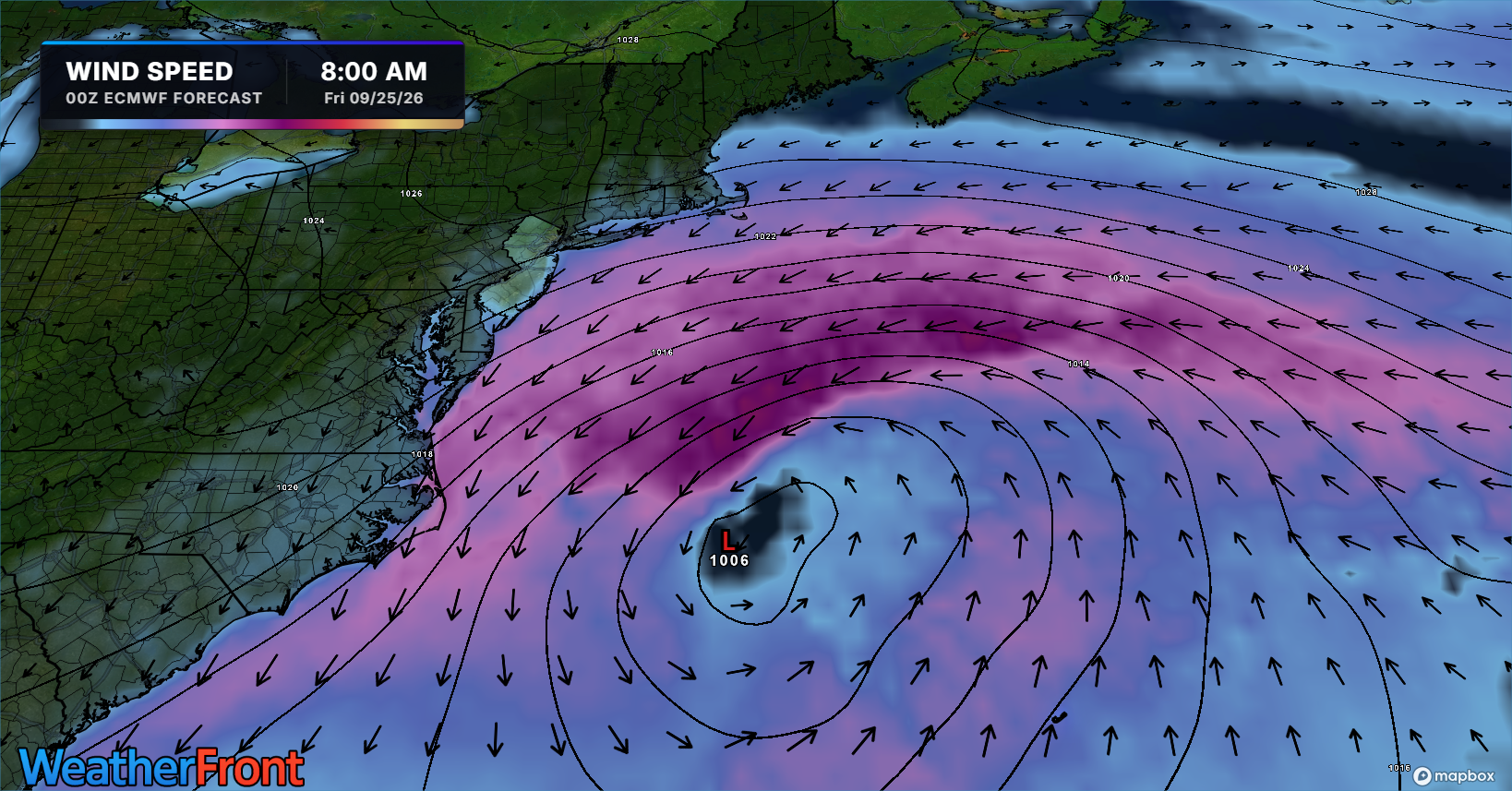
Strong northeast winds will continue pushing ocean water toward the coast. Gusts could reach 40 to 50 mph along the beaches of Atlantic and Cape May counties, with gusts around 35 to 40 mph farther north. Those winds will also create high surf and dangerous rip currents.
Tuesday will be the main rainy day. Wednesday through Friday should be mostly dry, aside from a few possible sprinkles. Inland areas will mainly deal with gusty winds and a raw feel.
Conditions should begin improving Saturday as winds turn more northerly. However, some tidal flooding could continue into the weekend, and Sunday’s weather will depend on how quickly the coastal storm moves away.
Tired of water in your basement or crawlspace? Trust Finally Dry Waterproofing’s family-owned company to fix it right. We install permanent drainage solutions guaranteed for 2 ownerships with no limit! Get your FREE inspection at finallydrywaterproofing.net.
The Jersey Shore is expected to see its first nor’easter of the cool season beginning Tuesday, with impacts potentially lasting through the weekend.
A strengthening low-pressure system moving up the East Coast is expected to produce persistent northeast winds for several days. While the exact track remains uncertain, rounds of tidal flooding are expected, especially around the Wednesday, Thursday and Friday high tides.
Beach erosion and gusty onshore winds are also expected. Recent beach replenishment projects could help limit some erosion impacts.
The biggest uncertainties involve the severity and frequency of coastal flooding and how much rain falls. Some periods could feature only scattered showers, while one or two days could turn much wetter.
More specific flooding and rainfall details should become clearer as the storm approaches.
SPONSOR:NJ beaches generate billions in revenue, supporting thousands of jobs and businesses. If they erode, our economy collapses. Federal beach funding was cut in 2025. Only the American Coastal Coalition fights 24/7 in DC to restore it. Protect your beach and business. Join today: americancoastalcoalition.org
🥳SATURDAY’S FORECAST | Some parts of the Jersey Shore will be totally dry until Sunday night! Yes, I said it. Either way, enjoy what we got today, it’ll be the nicest day up and down the coast until at least…. next Sunday?
Come visit Headley Family Farm at 120 Province Road in West Creek! It’s where farming the pines meets the Jersey Shore. Get your Jersey Fresh produce here. Open weekends and some weekdays. Call us at 609-848-3763 or follow us on Facebook, too!
😎FRIDAY’S FORECAST | This weekend is dry until Sunday. Sunday is not all bad though! Depending on where you are, you’ll be dry all day long.
Beach weather’s coming to an end, though. Next week looks… yucky.
🏈 Your Rutgers tailgate headquarters! Parking at St. George is only 500 yards from SHI Stadium and features 500+ spots, clean restrooms, and quick access to River Road. It’s where Joe parks! Purchase at: www.rutgersparking.com.
The Jersey Shore is reaching a noticeable seasonal milestone Thursday evening as daylight continues its rapid September decline.
September 17 marks the final sunset at or after 7 p.m. for the beaches of Monmouth and Ocean counties. Just one month ago, there was still plenty of daylight at 7 p.m. By mid-October, it will already be dark by that time.
Atlantic and Cape May counties have a little more time. Their final 7 p.m. sunsets will arrive this weekend.
The quickly changing sunset times are part of the Jersey Shore’s fastest loss of daylight of the year. Around the September equinox, the region loses more than 2.5 minutes of daylight each day.
It’s not just the amount of daylight that is changing. The sun itself is also noticeably lower in the sky.
On September 17, the sun’s peak angle over the Jersey Shore is about 21 degrees lower than it was on the summer solstice in June. That lower sun angle means less direct sunlight, longer shadows and earlier sunsets.
And with leaves beginning to change, the signs of fall are becoming harder to miss.
Why settle for big chains? Choose Just4Wheels’ family-owned locations all across NJ! Rent brand-new sedans, passenger vans, box trucks and more today! Visit www.just4wheels.com or call 877-650-3500.
NOTE: This story was originally published on April 4. It was updated on Sept. 16 to account for the “super” El Nino declared by NOAA.
Goodbye La Niña and hello El Niño – a “super” El Niño.
A “super” or very strong El Nino became official on Sept. 14, 2026 per NOAA’s update. This shift in the Earth’s long-term weather patterns will define how we experience the upcoming hurricane season, as well as the snow and cold of next winter.
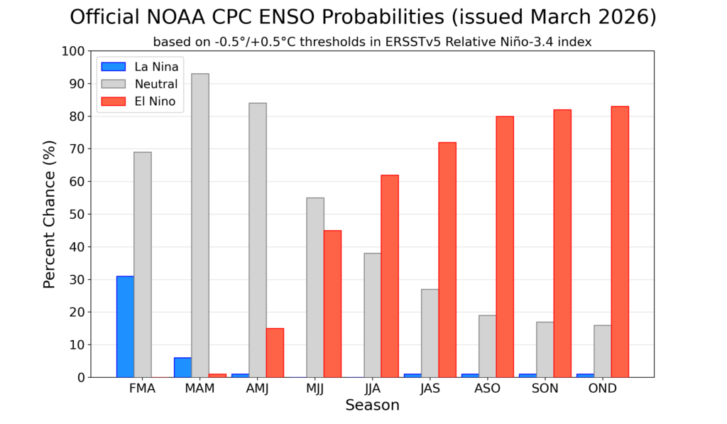
Forecasters from the National Oceanic and Atmospheric Administration give El Niño a greater-than-60% chance of developing during the summer. By the fall, during the peak of hurricane season, it’s an 80% chance.
By July, the chances of an El Nino developing are over 50% (via NOAA)
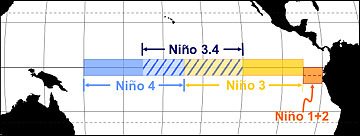
El Niño or La Niña is part of the El Niño Southern Oscillation (ENSO). This refers to the water temperatures off the Equatorial Pacific Ocean, from roughly Peru westward 7,000 miles. When water temperatures are warmer than average, it’s El Niño. When it’s cooler than average, it’s La Niña.
Via NOAA
Meteorologists break this down into four different zones within the ENSO region. I won’t explain it much here, but where those warmer temperatures are this summer and beyond will make a slight difference in what our long-term forecast will be.
Since the summer of 2024, we have been in La Niña. That typically means milder winters. However, both the 2024-2025 winter, and this past winter, were colder than average.
The frozen tundra of snow and ice we experienced for weeks this past winter bucked the La Niña trend, too. For hurricane season, 2024 was more active than usual, while 2025 was about average. That checks out with a La Niña pattern.
Let’s look at what El Niño will mean for both the 2026 hurricane season, and the 2026-2027 winter, plus what a “super” El Niño could mean for New Jersey.
Quieter hurricane season likely
When El Niño is present, hurricane activity in the Atlantic Hurricane Basin goes down; it’s that simple. The Atlantic Hurricane Basin averages 14 named storms – seven hurricanes including three major hurricanes (Category 3, 4 or 5) per season, per Colorado State University. Since 1990, there have been 11 hurricane seasons with El Niño. Seven were less active, while two were about average and two were more active.
More than likely, this hurricane season will be as active or less active than average. With a 24% chance of the eye of a tropical storm or hurricane being within 50 miles of the Jersey Shore, that number should be lower as well. Hurricane season officially runs from June 1 to Nov. 30.
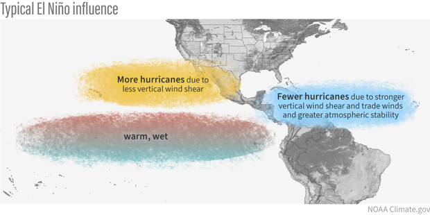
During El Niño, there is stronger windshear in the tropical Atlantic Ocean. Windshear is a change of wind direction or speed as you go up from the surface. This, in short, rips apart developing cyclones.
Winter temperatures
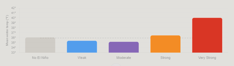
The stronger the El Niño, the warmer the temperatures. By itself, El Niño doesn’t mean much for our temperatures during the winter. Since ENSO records began in the 1950s, winters with El Niño end up about average at Atlantic City International Airport and the Sen. Frank S. Farley State Marina in Atlantic City.
However, when you look at the intensity of the El Niño, the pattern becomes clear.
Very Strong: 4.0 degrees warmer than average
Strong: 0.5 degrees warmer than average
Moderate: 0.7 degrees colder than average
Weak: 0.5 degrees colder than average.
Mean temperature between December and February for Atlantic City International Airport and Sen. Frank S. Farley State Marina in Atlantic City, based on the intensity of the El Nino (graphic is from Claude Artificial Intelligence, via NOAA data).
The stronger the El Niño, the warmer the temperatures. That’s because the Pacific jet stream – the river of air about 30,000 feet high that separates two airmasses – pushes into the Northeast. That means more opportunities for us to be south of the jet stream, taking in milder air.
Winter snow: One clear signal
Like winter temperatures, using El Niño alone doesn’t produce a big trend in what snow could look like for a winter. Generally, it’s a little less snowy than average. However, when you look at the type of El Niño, there is a trend that screams off the chart.
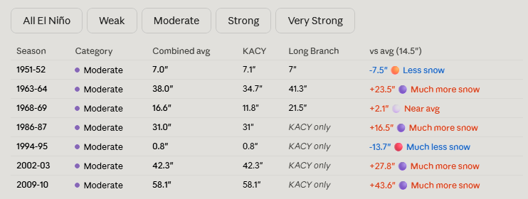
When El Niño is in a moderate phase, it’s 13 inches snowier than average. For the South Jersey shore, that’s 25 to 30 inches of snow. Farther up the coast, that’s roughly 30 to 35 inches of snow.
Here’s the snow breakdown for Atlantic City International Airport and Long Branch, by El Niño phase.
Weak: 3.5 inches below average
Moderate: 13.2 inches above average
Strong: 3.4 inches below average
Very strong: 0.2 inches above average
Winter snowfall totals for the Jersey Shore, based on the intensity of the El Nino (graphic is from Claude Artificial Intelligence, via NOAA data)
The last two moderate El Niño winters were 2009-’10 and 2002-’03. Both brought plenty of snow, and winter storms. That included:
On Feb. 5-7, 2010, over 20 inches of snow fell roughly south of the Atlantic City Expressway. Meanwhile, New York City experienced less than 4 inches of snow.
A few days later, the Feb. 9-11 winter storm brought over half a foot of snow to the shore.
The Feb, 16-18, 2003, winter storm, known as the President’s Day II or PDII storm, dropped over 18 inches of snow on much of the Jersey Shore and ranks as the sixth strongest winter storm on NOAA’s Northeast Snowfall Impact Scale.
Moderate El Niños sit in a weather sweet spot for winter storms in New Jersey. They enhance the jet stream’s pattern in a way that funnels nor’easters up the coast without warming the region enough to flip precipitation to rain.
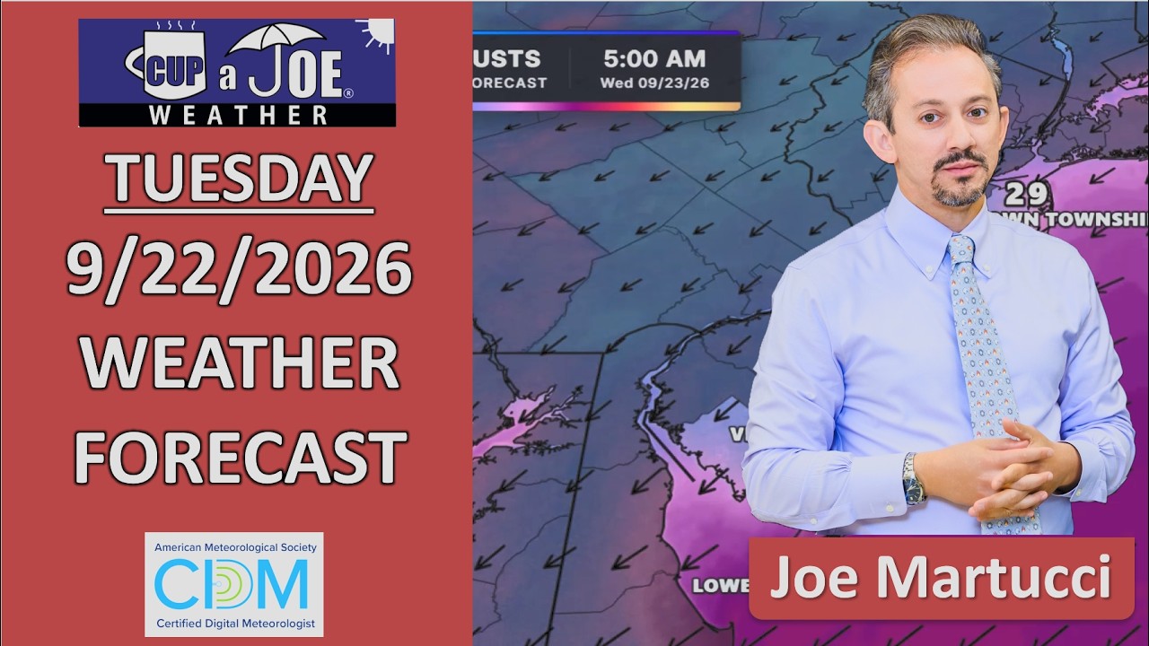
😎TUESDAY’S FORECAST | For the first time in NINE weeks, we have a dry workweek. Some think that means a boring weather video, but not here at the Jersey Shore. There are a few exciting things to talk about!
Tired of water in your basement or crawlspace? Trust Finally Dry Waterproofing family-owned company to fix it right. We install permanent drainage solutions guaranteed for 2 ownerships with no limit! Get your FREE inspection at finallydrywaterproofing.net .