Tag: meteorology

  • September’s Relentless Flooding: What It Means for NJ

    September’s Relentless Flooding: What It Means for NJ

    LISTEN TO THE SHOW HERE

    September gave New Jersey a warm start, a welcome break from drought and a coastal storm that kept coming back for more.

    In our monthly weather roundup, I joined Dr. John Krasting, New Jersey State Climatologist, to unpack a month that went from beach weather to flooded streets. We also looked at what a powerful El Niño could mean for the months ahead.

    A nor’easter that wouldn’t quit

    The September nor’easter’s biggest story wasn’t just how high the water rose. It was how long the flooding lasted.

    Dr. Krasting reported 12 high tide cycles with at least minor flooding at Atlantic City and Cape May during the September 22–30 period. Those were flooding tides across that stretch, rather than 12 straight flooded high tides.

    He said that kind of repeated flooding hadn’t been seen there since the December 1992 nor’easter.

    I saw the impacts firsthand in Highlands on Saturday morning. In the lower part of town, floodwater reached several blocks inland. Water spilled over the bulkhead and rose above my knee-high boots.

    Strong winds pushed water toward shore for days. High tides and heavy rain added to the trouble. Dr. Krasting explained that when several sources of flooding overlap, the impacts become harder to measure and compare.

    The wind was fierce, too. Surf City recorded a peak gust of 74 mph, while Harvey Cedars reached 69 mph.

    Although the storm’s turn toward New Jersey brought comparisons to Sandy, Dr. Krasting stressed that Sandy was a much larger storm. Similar tracks do not mean similar impacts.

    Rain brought some good news

    September’s rain also helped ease New Jersey’s long drought.

    Preliminary statewide rainfall totaled 6.16 inches, about two inches above normal. If those numbers hold, September would rank as the state’s 17th wettest.

    It also marked the third straight month with above-average rainfall.

    Dr. Krasting reported that New Jersey had left drought status on the U.S. Drought Monitor, though some areas remained abnormally dry. The state’s drought warning had also been lifted.

    Still, water underground remained low in parts of the coastal region. Recovery takes time, even after several wet months.

    Warm nights stood out

    September’s preliminary statewide average temperature was 68.2 degrees, about 1.3 degrees above normal.

    The warm nights were especially notable. Some locations stayed in the mid-70s overnight early in the month. Before the nor’easter arrived, much of September offered the warm weather many Shore residents call “local summer.”

    What about winter?

    Our discussion also covered a strong El Niño, a pattern involving unusually warm water in the tropical Pacific.

    Dr. Krasting explained that it can strengthen a major storm track, potentially bringing more coastal storms and precipitation.

    That does not guarantee a snowy winter. Temperatures and the timing of cold air still matter.

    After September’s repeated flooding, the question heading into winter is whether future storms will bring those same ingredients together again.
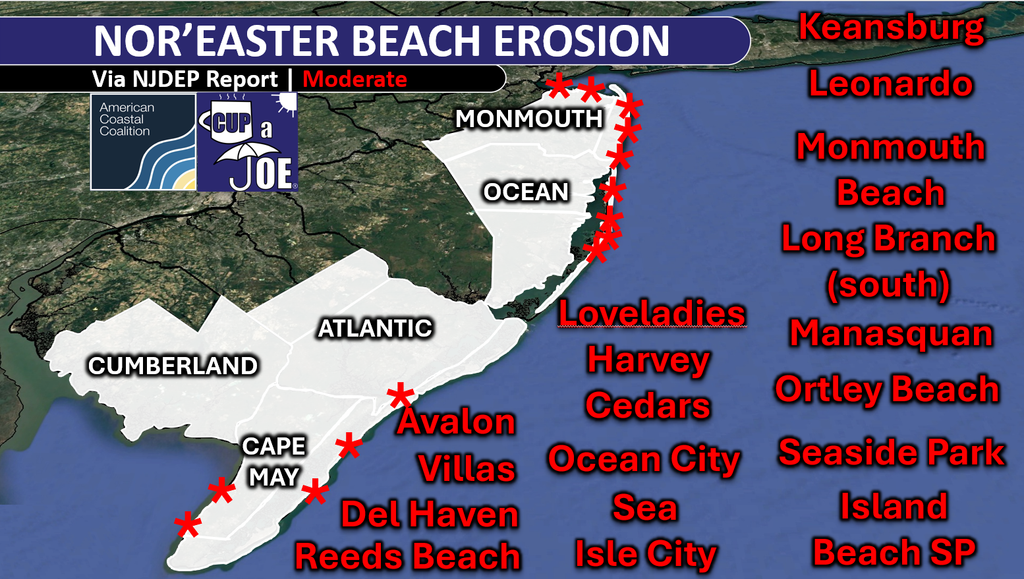
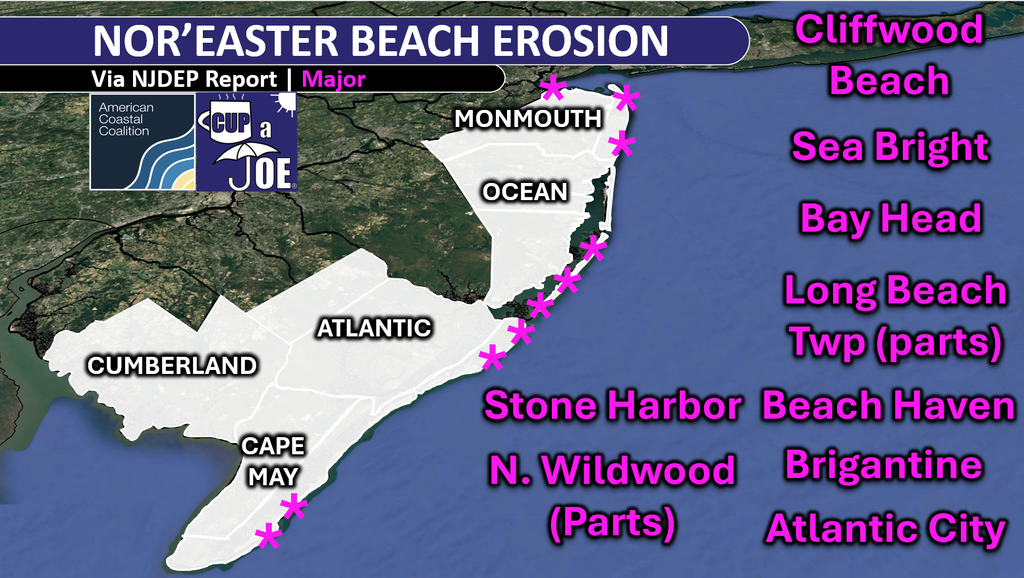
  • NJDEP Post Nor’easter Report: 10 beaches had “major” erosion.

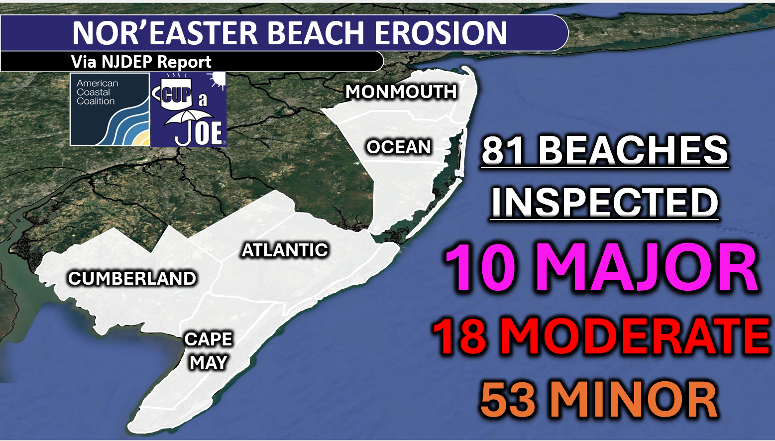
    NJDEP Post Nor’easter Report: 10 beaches had “major” erosion.

    The NJDEP went to every beach in NJ and here’s what they found.

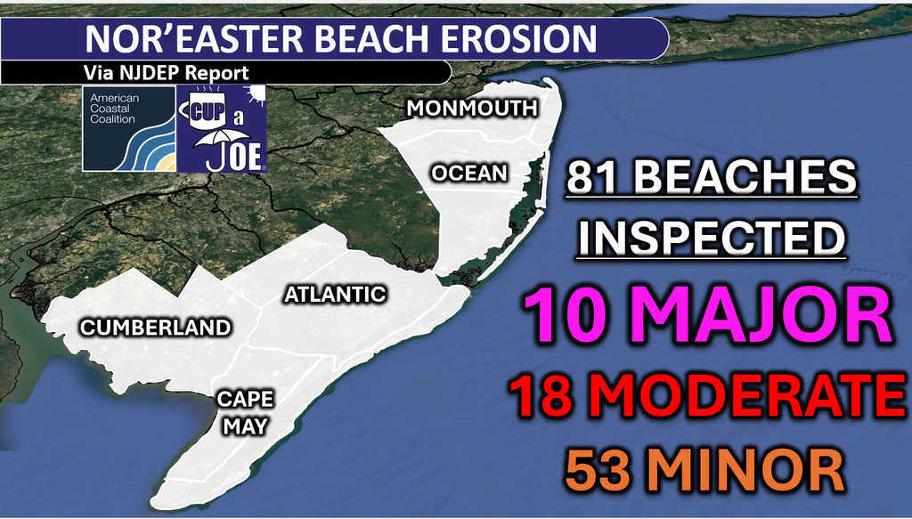
    10 beaches with major erosion, 18 beaches with moderate erosion, 53 beaches with minor erosion.

    Honestly, I thought it’d be worse. The multiple high tides with over 3 feet of storm surge can create major scarping (cliffs of sand) quickly. Cumberland County fared the best. This wasn’t a Delaware Bay storm this time.

    Still, it was significant, and early. Keep in mind that nor’easter season doesn’t traditionally begin until Mid-October. With a very strong to record El Nino, more of this is certainly possible.

    The nor’easter brought up to 12 consecutive tides with tidal flooding, and beach erosion, to the Jersey Shore. Nearly every station that faces that Atlantic Ocean had six consecutive high tides with flooding.

    Furthermore, tides gauges had one of their highest tides on record that Saturday morning (9/26). That included Atlantic City, where the 12th highest tide since 1911. That’s the 12th highest out of over 80,000 high tides.

    Strong winds Friday night and Sunday morning also helped to erode beaches. Gusts topped 60 mph in Avalon (Cape May County), Ship Bottom (67 mph), Harvey Cedars (69 mph), Island Beach State Park (70 mph) and Surf City (74 mph).

    Read their full report here. How’d you make out?

  • Your Jersey Shore Weekend Weather Forecast (10/3 to 10/4)

    Your Jersey Shore Weekend Weather Forecast (10/3 to 10/4)

    More seasonable temps

    Rain comes at the worst time Sunday.

    First frost in the Pine Barrens??

    Come visit Headley Family Farm at 120 Province Road in West Creek! It’s where farming the pines meets the Jersey Shore. Get your Jersey Fresh produce here. Open weekends and some weekdays. Call us at 609-848-3763 or follow on Facebook, too!

  • Rutgers vs. Indiana Football Weather Forecast (10/3/2026)

    56-35-3 on clear days with highs in the 70s.

    85-52-3 during clear October games. (via our Rutgers football weather archive)

    It’s a blackout beauty. Let’s shock the world. Go RU .

    🏈 Your Rutgers tailgate headquarters! Parking at St. George is only 500 yards from SHI Stadium and features 500+ spots, clean restrooms, and quick access to River Road. It’s where Joe parks! Purchase at: www.rutgersparking.com.

  • Nor’easter is OFFICIALLY OVER! Locals’ Summer weather returns to NJ

    😎WEDNESDAY’S FORECAST | I’m officially declaring the nor’easter over. We have a tiny bit of tidal flooding in the nooks and crannies of the back bays. That’s it though.

    Enjoy the sunshine and enjoy the 70s! BIG changes next week.

    For the latest and greatest interviews with artists, authors and entrepreneurs—as well as thoughtfully curated lists of favorites that are never bought and paid for–visit jennypennywriting.com!

  • Strange political bedfellows federal flood insurance fight | Tidal Flooding Talk

    Strange political bedfellows federal flood insurance fight | Tidal Flooding Talk

    LISTEN TO THE PODCAST HERE

    A fight over flood insurance is putting the Trump administration at odds with Republican officials. For Jersey Shore homeowners, the debate comes down to a familiar concern: How much more will protecting your home cost?

    On this episode of Tidal Flooding Talk, meteorologist Joe Martucci welcomes POLITICO reporter Tom Frank to explain the politics behind rising flood insurance bills.

    At the center is FEMA’s Risk Rating 2.0, a pricing system designed to make insurance costs better reflect each property’s flood risk. Frank explains that the federal flood insurance program has long charged some homeowners less than what was needed to cover their risk. Major disasters have exposed that gap, forcing the program to borrow money.

    But bringing prices closer to the actual risk creates another problem: Coverage becomes harder for some families to afford.

    That tension sparked a lawsuit from Republican attorneys general during the Biden administration. According to Frank, the Trump administration inherited the case and continued defending the system, putting it on the opposite side of fellow Republicans seeking relief from rising costs.

    The dispute shows why flood insurance politics can be more complicated than red versus blue.

    “The split is geographic,” Frank says.

    Lawmakers representing coastal states often want the same thing: affordable coverage for their residents. That can put Republicans from Florida and Louisiana alongside Democrats from New York and New Jersey.

    The broader question is who should pay. Should homeowners shoulder more of the cost of living in places that flood? Or should the federal government spread more of that burden across taxpayers to keep coverage affordable?

    Frank also discusses FEMA’s flood map updates. When maps place additional homes in high-risk areas, some owners with mortgages can face a requirement to buy flood insurance. That adds another expense to already tight household budgets.

    Meanwhile, the water does not wait for a political agreement. Coastal storms, heavy rain and overflowing rivers can damage homes regardless of party affiliation. Frank also reminds viewers that standard homeowners insurance generally does not cover flood damage.

    For the Jersey Shore, this debate reaches well beyond Washington. It touches the cost of owning a home, recovering from storms and remaining in a coastal community.

    Watch the full conversation on Tidal Flooding Talk, presented by the New Jersey Coastal Coalition.

  • Cup A Joe Weather Interviewed across America during 2026 NJ nor’easter

    Cup A Joe Weather Interviewed across America during 2026 NJ nor’easter

    The Jersey Shore was the focus point for this September 2026 nor’easter that will be remember for years in the region. Leading up to and during the storm, regional and national news outlets turned to Cup A Joe Weather and Drone.

    We shared our intense local reporting and tidal flooding expertise to hundreds of thousands of people.

    On TV and Streaming

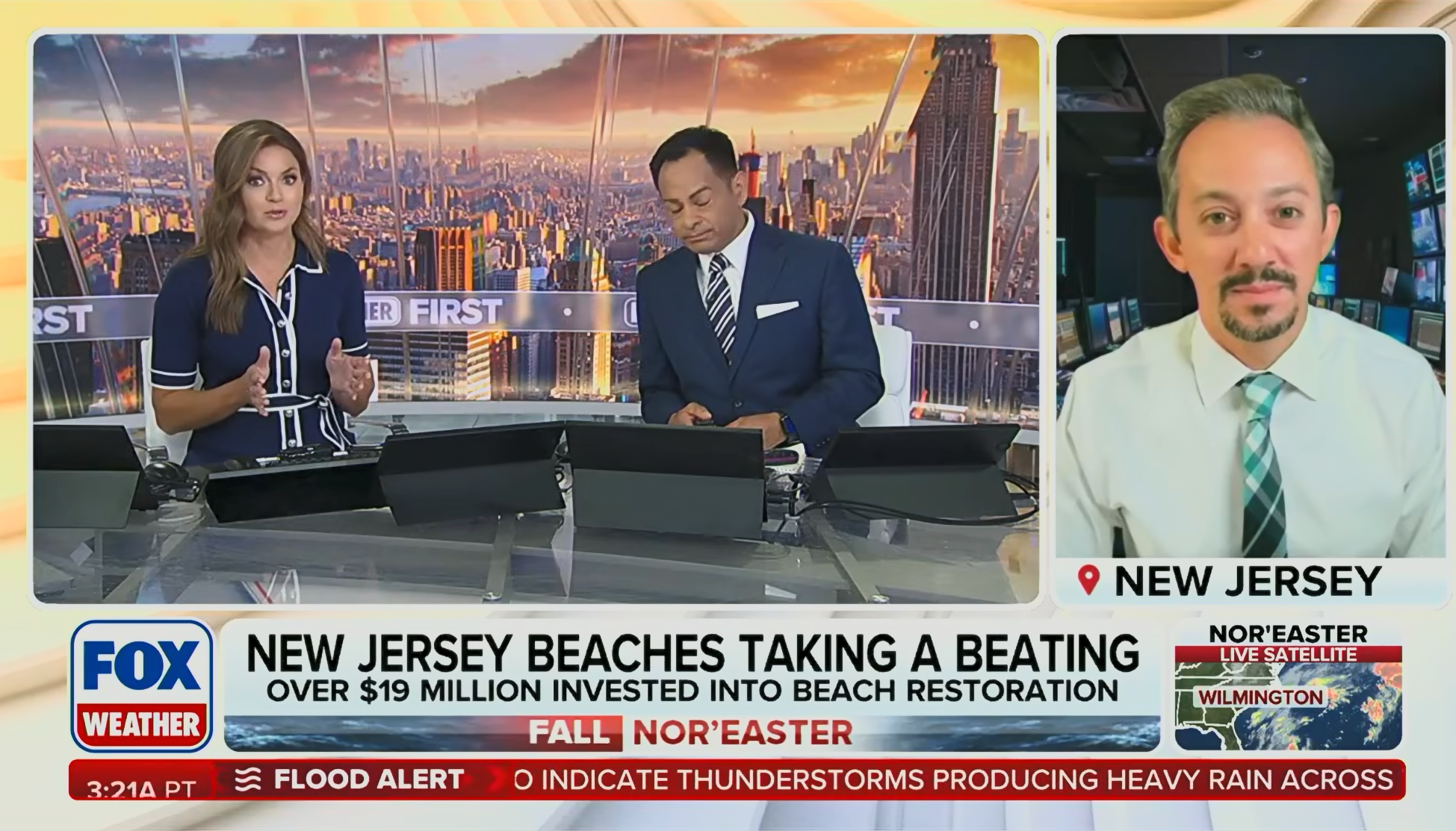
    9/24/2026 615AM: Interview on FOX Weather with Britta Merwin and Craig Herrera

    9/25/2026 645AM: Interview on FOX Weather with Britta Merwin and Craig Herrera

    9/25/2026 10AM: Interview with WNYW-TV’s (Fox 5 New York) Dan Bowen

    9/25/2026 730PM: Interview with LiveNow from FOX on location in Sea Bright with Anna Marsick

    9/27/2026 530PM: Interview on LiveNOW from FOX with Andy Mac

    Quoted in Articles

    AXIOS Philadelphia’s Mike D’Onofrio quoted Meteorologist Joe Martucci in his story titled Nor’easter arrives in the Philly region

    Joe Martucci quoted in AXIOS Philadelphia.

    The Cape May County Herald talked to PJ Hondros, Vice President, ShorelySafe, about the tidal flooding seen in the county with the nor’easter.

    ShorelySafe provided shore-smart tidal flooding and weather solutions to your municipality, county or community.

    On the Radio

    Chaz and AJ in the morning in Connecticut and Long Island saw the flooding in Cape May. They called on Meteorologist Joe Martucci to update listeners in southern New England about what the weekend brought to the area.

    The interview can be heard from 0:00 to 10:15. Chaz and AJ said Joe talks a lot. Joe said his job is to talk! 😂

    Chaz and AJ are heard on 99.1 WPLR in New Haven, CT.

  • Sunday Evening NJ Nor’easter Update: It’s almost over

    Sunday Evening NJ Nor’easter Update: It’s almost over

    🌀SUNDAY EVENING VIDEO UPDATE | The tide’s rising again, the rain is coming down (at least in Monmouth-Ocean) and this storm ain’t done yet.

    The good news is we’re almost done with it. Tune in…

    ShorelySafe® helps organizations forecast tidal flooding 84 hours ahead, reduce flood risk and lower insurance costs with property-level flood intelligence.

    Request a meeting: www.shorelysafe.live

  • Why the September 2026 nor’easter made a landfall in New Jersey

    Why the September 2026 nor’easter made a landfall in New Jersey

    Powerful Nor’easter Makes Landfall at the Jersey Shore

    A powerful nor’easter made landfall along the Jersey Shore Sunday morning, bringing major tidal flooding, strong winds and widespread power outages to parts of the coast.

    The center of the storm moved ashore near Barnegat Inlet, between Barnegat Light and Island Beach State Park. Around the center, conditions briefly became calmer, with an eye-like feature showing up near parts of Ocean County.

    The biggest impacts were focused along the coast rather than inland New Jersey. Monmouth and Ocean counties dealt with the strongest onshore winds, significant tidal flooding and thousands of power outages. During the late morning, about 25,000 customers were without power in Monmouth County and roughly 36,000 were out in Ocean County.

    Conditions were different farther south. Atlantic and Cape May counties still experienced gusty winds and flooding, but winds became more offshore there. That helped keep wind impacts and water levels lower than farther north.

    Flooding remained a concern around Barnegat Bay, where water drains more slowly than along the open coast. Areas including Toms River, Waretown, Forked River, Lacey and Manahawkin could continue seeing lingering water even after the storm begins pulling away.

    Another round of heavier rain was also possible Sunday evening before the nor’easter gradually winds down.

    Know More

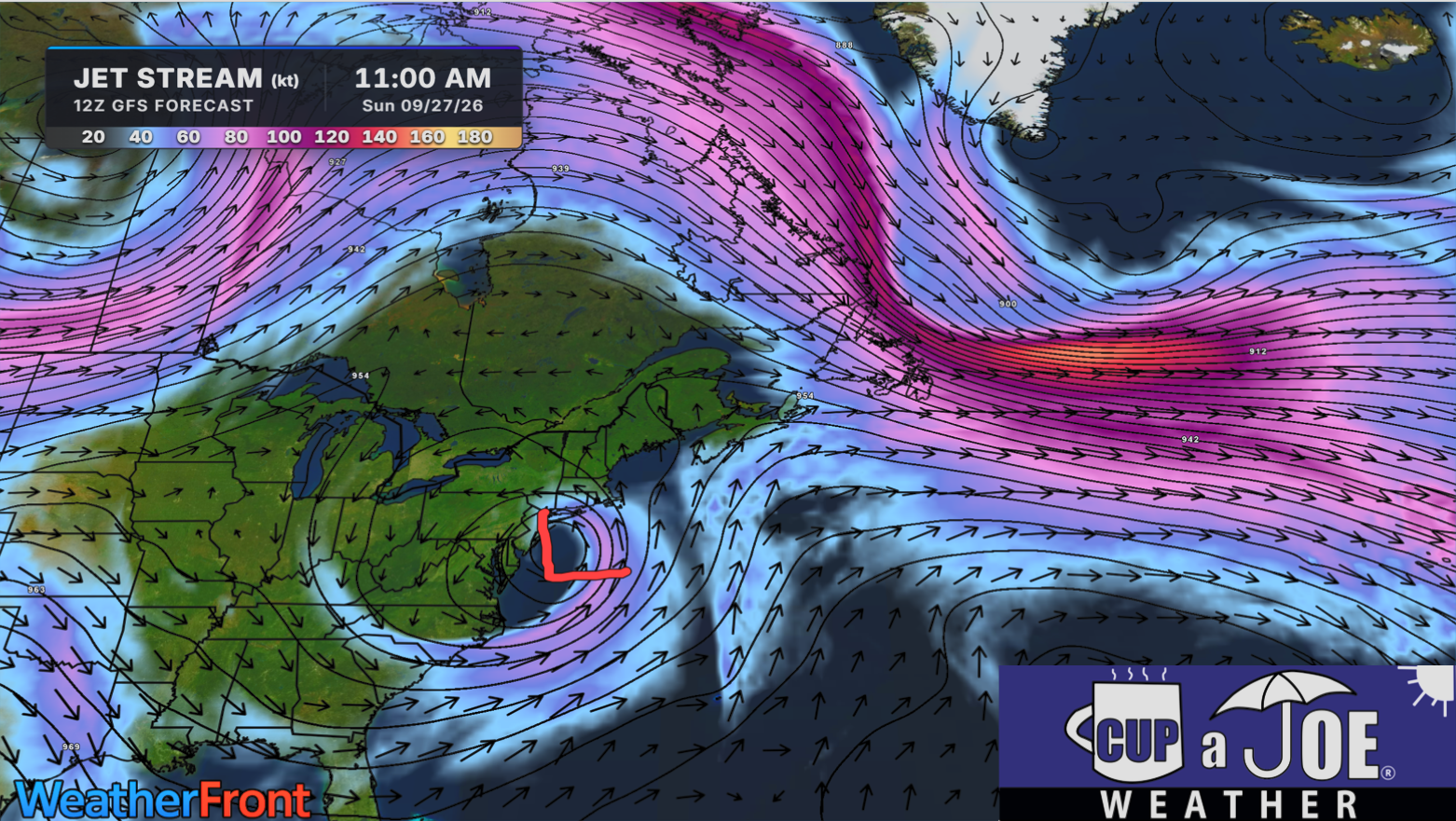
    The biggest reason this nor’easter lingered for days can be found high above the surface, at the jet stream level.

    Normally, storm systems get caught in the faster west-to-east flow of the jet stream and are pushed along. This time, the main, faster jet stream was displaced well to the north of New Jersey. Another branch of stronger upper-level winds was farther south.

    In between them, a piece of upper-level energy broke away from the main flow. Meteorologists call this a closed low or cutoff low.

    Think of it like a leaf breaking away from a fast-moving river and getting caught in a slow eddy. Instead of quickly moving east, this system was largely separated from the faster atmospheric winds that normally steer storms.

    That allowed the low-pressure system to meander and circle around the Mid-Atlantic for several days.

    The cutoff low was also unusually strong. As the surface low followed the circulation around it, the storm strengthened and eventually moved into New Jersey Sunday morning. Its slow movement helped prolong the northeast and east winds along the coast, allowing water to repeatedly pile into the Jersey Shore and back bays.

    That persistence matters with tidal flooding. One high tide can cause problems, but several tidal cycles with sustained onshore flow can keep adding water faster than some bays can drain it.

    Barnegat Bay is especially vulnerable to this. Water enters through relatively limited inlets and can take time to escape. That allowed elevated water levels to linger around places such as Waretown, Forked River, Toms River and Manahawkin even as conditions began changing elsewhere.

    The pattern finally starts breaking down when the closed low gets close enough to the main jet stream to become absorbed back into the faster flow. In this case, that process is expected around Tuesday.

    Once that happens, the atmospheric “traffic jam” breaks. The storm gets picked up by the jet stream and accelerates away from the region.

    So while the surface storm produced the wind, rain and flooding people experienced, the unusual jet-stream setup is a major reason New Jersey dealt with the nor’easter for so long.

  • The 2 ways Superstorm Sandy and the 2026 Nor’easter are the same

    The 2 ways Superstorm Sandy and the 2026 Nor’easter are the same

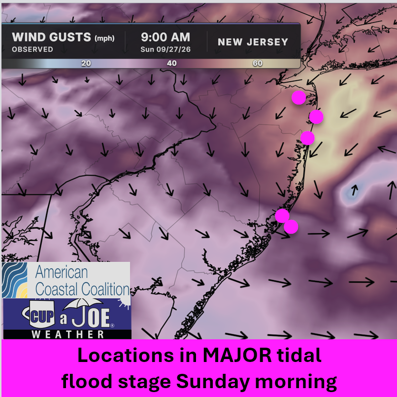
    1045AM SUNDAY FLOODING UPDATE | I’m getting reports of flooding nearly as bad as Saturday morning today. Major stage is gripping Keansburg, Sea Bright, Shark River Hills, etc.

    Why? The track of the storm and the direction of the wind.

    This is where we can bring Superstorm Sandy into play. Anywhere NORTH of where these make landfall had onshore winds, pushing the tide higher.

    Winds are from the northeast in Monmouth and Ocean Counties.

    South of there, they’re offshore winds. Cape May and Atlantic Counties are in moderate stage flooding.

    This is why miles matter in a storm track. Had this storm been 70 miles further south, all of the Jersey Shore would be in major flood stage.

    NJ beaches generate billions in revenue, supporting thousands of jobs and businesses. If they erode, our economy collapses. Federal beach funding was cut in 2025. Only the American Coastal Coalition fights 24/7 in DC to restore it. Protect your beach and business. Join today: americancoastalcoalition.org