If your phone suddenly sounded a loud emergency alert Thursday afternoon, you were in the path of a dangerous flash flooding threat in Monmouth County.
The National Weather Service issued a Flash Flood Warning at 2:18 p.m. Thursday, Aug. 27, after thunderstorms dumped between 1.5 and 2.5 inches of rain across parts of the area. Around 3:15 p.m., rainfall totals had climbed to between 2.5 and 3.5 inches in some locations, with flash flooding reported in Keyport and Holmdel.
That’s when the loud message was received on many smartphones. That’s called a Wireless Emergency Alert, or WEA. These alerts are distributed through the federal Integrated Public Alert and Warning System, known as IPAWS.
But not every weather warning triggers a Wireless Emergency Alert.
For severe thunderstorms, the National Weather Service uses three damage-threat categories: base, considerable and destructive. Only a destructive Severe Thunderstorm Warning automatically triggers a WEA. That designation requires winds of at least 80 mph and/or hail at least 2.75 inches in diameter, roughly baseball-sized.
Flash Flood Warnings also use escalating damage-threat categories. Wireless Emergency Alerts are generally triggered when the threat reaches the considerable or catastrophic level.
In other words, the loud alert is generally reserved for weather situations the National Weather Service considers especially dangerous and requiring immediate action.
Wireless Emergency Alerts are also used for threats beyond weather, including AMBER Alerts, certain public safety emergencies and national emergency messages. NOAA Weather Radio, meanwhile, remains a separate system that can broadcast a broader range of National Weather Service watches, warnings and other hazard information.
Thursday’s flooding showed why the higher-level alerts exist: several inches of rain fell in a short period, roads flooded and portions of Route 36 were forced to close.
🌦️FRIDAY’S FORECAST | Sun n’ showers today… sun n’ no showers for your weekend! We got a good one ahead, Jersey Shore.
🏈 Your Rutgers tailgate headquarters! Parking at St. George is only 500 yards from SHI Stadium and features 500+ spots, clean restrooms, and quick access to River Road. It’s where Joe parks! Purchase at: www.rutgersparking.com.
Note: The time of the partial eclipse in the video is supposed to be 10:33 p.m., not 9:33 p.m. Our apologies.
New Jerseyans who stay up late Thursday night could see the Moon turn a dramatic reddish-orange — if the clouds cooperate.
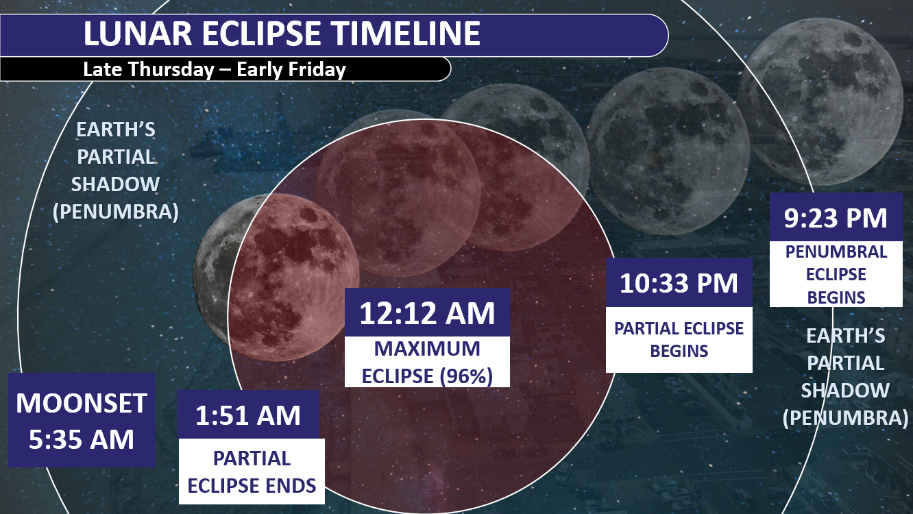
A deep partial lunar eclipse will take place Thursday night into early Friday morning, with 96.2% of the Moon’s visible surface covered by the darkest part of Earth’s shadow at its peak. That puts this eclipse exceptionally close to becoming a total lunar eclipse.
The eclipse begins subtly at 9:23 p.m. Thursday, when the Moon enters Earth’s penumbra, or faint outer shadow. At first, the difference may be difficult to notice.
The show becomes much more obvious beginning around 10:33 p.m., when the Moon starts moving into Earth’s umbra, its darker central shadow. From there, an increasingly large portion of the Moon will darken and take on shades of red, orange or copper.
Maximum eclipse arrives at approximately 12:12 a.m. Friday, when roughly 96% of the lunar disk will be immersed in the umbra. Only a thin portion of the Moon will remain brightly illuminated.
The reddish color happens because sunlight passing through Earth’s atmosphere is filtered before reaching the Moon. Blue and violet wavelengths scatter more readily, while more red and orange light makes it through the atmosphere and reaches the lunar surface.
The Moon will then gradually move out of the shadow. The partial eclipse ends around 1:51 a.m., while the final, much more subtle penumbral phase continues until about 3:01 a.m.
Will NJ actually see the lunar eclipse?
That’s the bigger question.
Unfortunately, the weather may not cooperate. A warm front moving through the region Thursday is bringing widespread showers and thunderstorms, along with plenty of cloud cover. The National Weather Service in Mount Holly says the warm front will be followed closely by a cold front Friday, keeping the region unsettled.
That means many parts of New Jersey could have clouds blocking the Moon during at least portions of the eclipse. However, any breaks in the clouds around midnight could provide a window to see the eclipse near its peak.
Unlike a solar eclipse, no special eclipse glasses are needed to safely look at a lunar eclipse.
And if the clouds win Thursday night, New Jersey will get another shot at an even bigger event in a few years: the next total lunar eclipse visible from the Garden State is June 26, 2029.
Why settle for big chains? Choose Just Four Wheels Car, Truck and Van Rental family-owned locations all across NJ! Rent brand-new sedans, passenger vans, box trucks and more today! Visit www.just4wheels.com or call 877-650-3500.
The Jersey Shore is entering its driest stretch of the year. At Atlantic City International Airport, the driest 30-day period runs from August 23 through September 21, with rain falling on roughly one in four days.
The chance drops to just 14% on September 5. Long Branch’s driest stretch runs from August 16 through September 14.
Weaker cold fronts, fewer thunderstorms and a jet stream positioned north of New Jersey limit rainfall. Nor’easter season has not started, leaving tropical systems as the region’s primary rain source.
I start my weekday mornings with Monmouth365 for my Monmouth County weather (from us!), local news, events, business updates, and positive stories from across the community. 📰 Subscribe free: www.monmouth365.beehiiv.com/subscribe?ref=5lTZKBW9hL
Weather warnings work best when they tell people what could happen in their own community—and when officials are honest about what forecasters still do not know.
That is the message from emergency manager Ashley Morris, who joined meteorologist Joe Martucci for a conversation about flash flooding, disaster planning and the complicated choices officials face when dangerous weather threatens.
Morris has understood the power of weather since childhood. At 7 years old, she would go outside during thunderstorms, count the seconds after seeing lightning and record what she observed in a lightning journal. That early interest eventually led her to study atmospheric science at Texas Tech University before earning a master’s degree focused on geography and natural hazards.
She once expected to work for the National Weather Service. Instead, she found emergency management and a way to combine her interest in weather with her passion for public safety.
Today, Morris believes effective weather communication begins with being visible and available to residents. Officials can build trust through social media, community presentations and other forms of regular outreach, she said. But the information must also be local enough to matter.
A statewide forecast may not answer the questions residents have about their town, neighborhood or daily work. In the Texas Hill Country, for example, Morris communicates with ranchers and other residents whose plans may depend on whether conditions are safe for cutting hay or conducting a prescribed burn.
“People are very interested” in what will happen specifically where they live, Morris said.
Clear communication also means avoiding technical jargon and resisting the urge to present every storm as the worst-case scenario. Emergency managers must prepare for the worst, Morris said, but repeatedly emphasizing extreme outcomes can exhaust residents and damage their trust.
“If I’m always messaging the worst-case scenario for every single storm, then that’s obviously going to burn them out,” she said.
Flash flooding makes that balance especially difficult. Forecasters may know the atmosphere can produce pockets of 5, 7 or even 10 inches of rain without knowing exactly where those totals will occur. Morris said residents and public-safety leaders deserve to hear both parts of that message: a serious threat is possible, but its precise location remains uncertain.
“We have no idea how to tell you where,” she said. “But it’s important to know that over the next 12 hours, it is possible and that we need to just be prepared to take action.”
Preparation begins well before the first raindrop. Morris reviews weather data each week and starts sending situation reports about three days before a concerning event. Those updates go to city and county elected officials, department leaders, first-response chiefs and others who may need time to act.
Public works crews may clear drains. Fire departments may consider adding staff for water rescues. If the threat grows, Morris can organize a briefing where agency leaders share concerns, plans and resource needs. An emergency operations center may then open to monitor forecasts, dispatch traffic and rescue calls while agencies coordinate in one room.
Morris said that process was used ahead of a July 16 flood affecting her river basin.
Her experience also shapes her argument for stronger local emergency-management offices. In some communities, the emergency manager is part time or responsible for several unrelated duties. Morris said trained, adequately staffed offices can prepare contracts, track supplies, organize damage assessments and keep the records needed to seek federal reimbursement after a disaster.
Even donated materials and volunteer hours may help offset a community’s share of certain disaster costs when they are properly documented, she said. Emergency-management staff can also pursue mitigation funding intended to reduce future losses.
The goal is not simply to respond faster. It is to save lives, protect public money and help communities recover.
Morris now chairs the American Meteorological Society’s Committee on Emergency Management, where she works to strengthen the connection between meteorologists and emergency managers. She said emergency managers need better weather training, while meteorologists need a fuller understanding of the staffing, political and operational challenges behind public-safety decisions.
That cooperation could produce better warnings, clearer action points and fewer weather-related deaths.
Still, Morris sees major holes in the recovery system. One became especially clear after recent Central Texas floods: damaged private roads and driveways can be essential in rural communities, yet they may be difficult to insure or repair through existing disaster-aid programs.
For Morris, the challenge shows why emergency management cannot begin when disaster strikes. It requires trusted communication, trained professionals and sustained investment long before the water starts rising.
TUESDAY’S FORECAST | We’ve entered our driest time of the year, on average. So will Mother Nature cooperate at the Jersey Shore? Mostly.
Tired of water in your basement or crawlspace? TrustFinally Dry Waterproofingg’s family-owned company to fix it right. We install permanent drainage solutions guaranteed for 2 ownerships with no limit! Get your FREE inspection at finallydrywaterproofing.net .
🥳SATURDAY’S FORECAST | Sorry for not showing my face in the video. My right eye is not looking good. I’ll spare you.
On the bright side, this weekend is NOT a washout. In fact, 90% of your daytime Sunday will be dry!
Come visit Headley Family Farm at 120 Province Road in West Creek! It’s where farming the pines meets the Jersey Shore. Get your Jersey Fresh produce here. Open weekends and some weekdays. Call us at 609-848-3763 or follow us on Facebook, too!
📽️FRIDAY’S FORECAST | The flooding rain and severe weather is gone today, but not for long. I got your weekend weather details on another flooding threat, here. Tune in!
🏈 Your Rutgers tailgate headquarters! Parking at St. George is only 500 yards from SHI Stadium and features 500+ spots, clean restrooms, and quick access to River Road. It’s where Joe parks! Purchase at: www.rutgersparking.com.