
Thanksgiving morning’s high tide will be the Jersey Shore’s biggest weather problem of the week.
The Cup A Joe Weather Team expects at least moderate tidal flooding at the Jersey Shore on Nov. 26. Heavy rain and strong winds could also slow holiday travel. Wednesday is the day to travel on trains or planes.
If you’re heading to or from a beach town, aim to make the trip by Wednesday evening. During Thursday morning’s high tide, water will cover low roads and cut off some routes between Shore neighborhoods and the mainland.
At a minimum, tidal flooding will look similar to the Columbus Day nor’easter just last year in 2025. That will be water in some unraised homes and businesses. Up to 18″ of water will be on the lowest lying areas, with a few inches of water in places that don’t typically get it dozens of times a year.
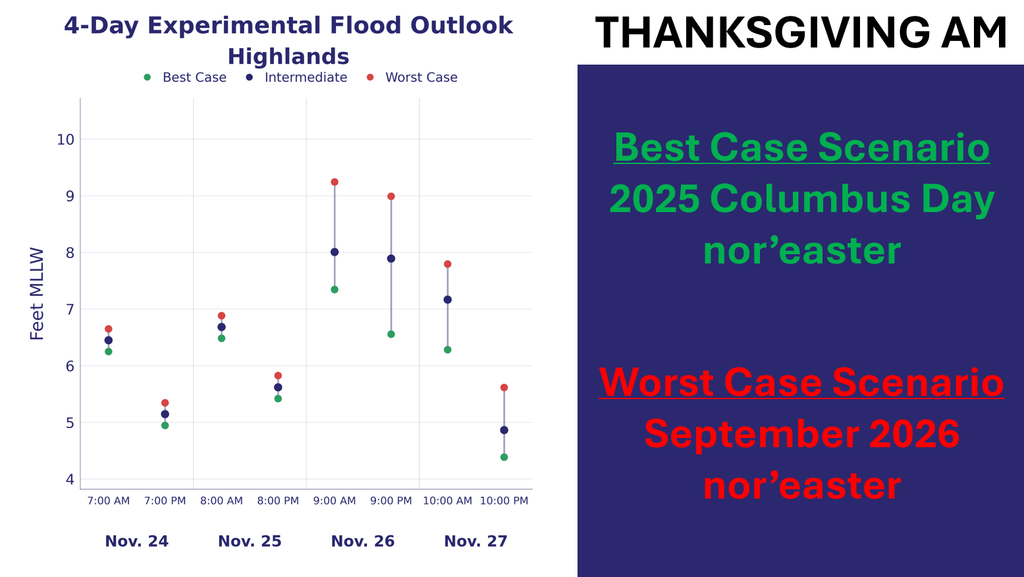
Heavy rain and strong winds could also delay flights Thursday. How hard it rains and how strong the winds get will depend on the storm’s track and strength. It’s still too early to say whether gusts will cause power outages. Cup A Joe Weather plans to share a first look Monday and a more detailed tidal flooding forecast Tuesday.
Friday looks mostly dry but windy, and flooding could return at high tide even after the rain ends. Saturday looks dry.
Before Thanksgiving, a smaller storm will pass offshore Sunday night. Monmouth and Ocean counties have the best chance of rain between 5 and 10 p.m., but most places will get less than half an inch. Gusts could top 30 mph, and rough surf could erode some beaches.
Monday morning’s high tide could bring minor flooding to a few spots in Cape May County and around Barnegat Bay. Inland, temperatures should climb well into the 60s Monday before a cold front moves through that night. Tuesday will feel much colder, with a brisk northwest wind and highs near 50.
Know More
For Thanksgiving, a blocking high to the north and a low approaching from the south could sustain northeast winds across a long fetch, the distance wind blows over water in roughly the same direction. Persistent onshore flow can raise water levels above the predicted astronomical tide. That extra water is storm surge. Add it to the astronomical tide and you get the storm tide.
One reasonable ShorelySafe high-end historical comparison is the January 2016 blizzard. NOAA’s Cape May gauge at the ferry terminal reached 9.0 feet above mean lower low water during that storm. Flood thresholds vary by gauge. At moderate stage, many roads can become impassable and vulnerable buildings can sustain damage.
Sunday morning’s dense fog in parts of Monmouth and Ocean counties was advection fog. When warm, moist air crosses cooler water, the air can cool to its dew point. If the incoming dew point is above the sea surface temperature and the air spends enough time over the water, tiny droplets can form. Onshore winds can then carry that fog inland.


