
A coastal storm is threatening on Thanksgiving that would make your turkey time brined in significant salt water from tidal flooding.
The combination of the king tide and a very strong signal for onshore winds has us tracking the tidal flooding siutation closely, both at Cup A Joe Weather and for our ShorelySafe flood and weather consulting towns.
Wednesday brings a king tide, NOAA’s term for an unusually high tide. Around a full or new moon, the sun, moon and Earth line up. The pull of the sun and moon combines to produce higher high tides. When the moon is closer to Earth, its pull is stronger, and the tide can rise even higher.
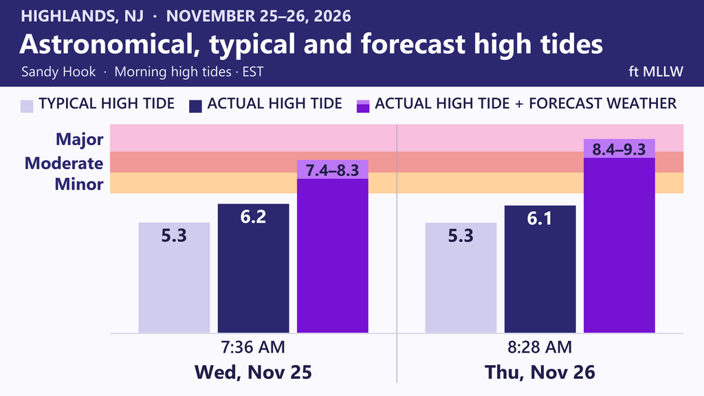
At Sandy Hook, Wednesday’s astronomical high tide alone will be within three inches of flood stage. The astronomical tide is the water level expected from the pull of the moon and sun, before wind or other weather effects come into play.
September’s nor’easter shows how much water a storm can add. On the morning of Sept. 26, 2026, the astronomical high tide in Atlantic City was about 4.8 feet. The tide gauge measured about 7.8 feet, roughly 3 feet higher. The Jersey Shore all saw a similar rise.
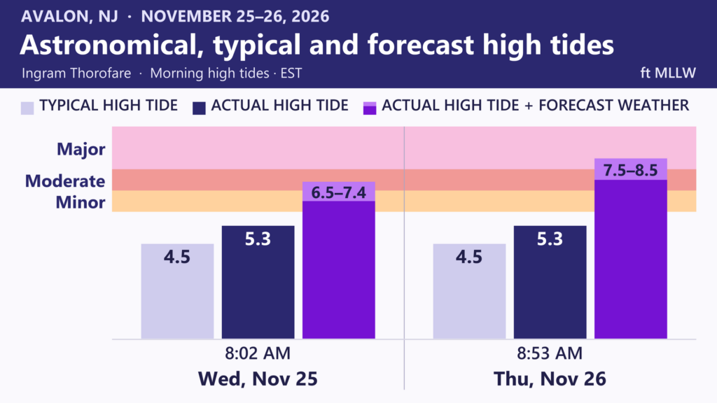
On Thanksgiving, tides will still be running nearly as high as Wednesday as a coastal storm approaches from the south.
However, a familiar set up will occur. Drying high pressure will be situated in Eastern Canada. This will block the coastal low pressure system from moving out to sea quickly.
The result are onshore winds for the Jersey Shore. That will pile water from the ocean into the bays and tidal rivers, which then threaten to flood land.
It’s too early to tell just how much tidal flooding there will be, let alone rain or wind. Even if there is no rain, tidal flooding still is a threat every morning from Nov. 25, through Thanksgiving and into Black Friday.
In fact, our in-house flood forecast is showing a reasonable best case scenario as a moderate stage tidal flood Thanksgiving morning, the kind that happens four or five times a year. Driving around the barrier islands will be difficult with water on the roads. Water would get into unraised, susceptible buildings and plenty of garages.
A reasonable worst case scenario is a repeat of the September nor’easter. The major stage tidal flooding is only see a couple of times a decade.
If your street usually floods, move your car to higher ground before high tide. If you’re visiting family, check the tide time for their town and leave extra time for a detour.
Our winter forecast expects well above average tidal flooding, with another significant flood like September well within possibility.
On Monday you can expect to hear from us as to whether rain and strong winds will accompany the tidal flooding. Expect an exact tidal flood forecast for Thanksgiving morning Tuesday.


