Why settle for big chains? Choose Just4Wheels’ family-owned locations all across NJ! Rent brand-new sedans, passenger vans, box trucks and more today! Visit www.just4wheels.com or call 877-650-3500.
NOTE: This story was originally published on April 4. It was updated on Sept. 16 to account for the “super” El Nino declared by NOAA.
Goodbye La Niña and hello El Niño – a “super” El Niño.
A “super” or very strong El Nino became official on Sept. 14, 2026 per NOAA’s update. This shift in the Earth’s long-term weather patterns will define how we experience the upcoming hurricane season, as well as the snow and cold of next winter.
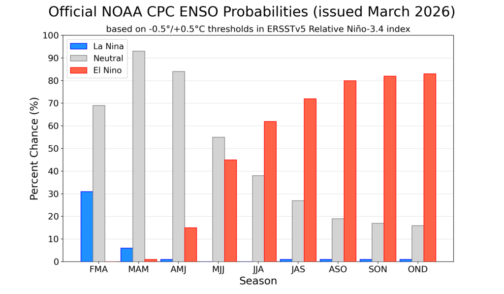
Forecasters from the National Oceanic and Atmospheric Administration give El Niño a greater-than-60% chance of developing during the summer. By the fall, during the peak of hurricane season, it’s an 80% chance.
By July, the chances of an El Nino developing are over 50% (via NOAA)
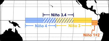
El Niño or La Niña is part of the El Niño Southern Oscillation (ENSO). This refers to the water temperatures off the Equatorial Pacific Ocean, from roughly Peru westward 7,000 miles. When water temperatures are warmer than average, it’s El Niño. When it’s cooler than average, it’s La Niña.
Via NOAA
Meteorologists break this down into four different zones within the ENSO region. I won’t explain it much here, but where those warmer temperatures are this summer and beyond will make a slight difference in what our long-term forecast will be.
Since the summer of 2024, we have been in La Niña. That typically means milder winters. However, both the 2024-2025 winter, and this past winter, were colder than average.
The frozen tundra of snow and ice we experienced for weeks this past winter bucked the La Niña trend, too. For hurricane season, 2024 was more active than usual, while 2025 was about average. That checks out with a La Niña pattern.
Let’s look at what El Niño will mean for both the 2026 hurricane season, and the 2026-2027 winter, plus what a “super” El Niño could mean for New Jersey.
Quieter hurricane season likely
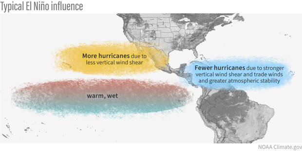
When El Niño is present, hurricane activity in the Atlantic Hurricane Basin goes down; it’s that simple. The Atlantic Hurricane Basin averages 14 named storms – seven hurricanes including three major hurricanes (Category 3, 4 or 5) per season, per Colorado State University. Since 1990, there have been 11 hurricane seasons with El Niño. Seven were less active, while two were about average and two were more active.
More than likely, this hurricane season will be as active or less active than average. With a 24% chance of the eye of a tropical storm or hurricane being within 50 miles of the Jersey Shore, that number should be lower as well. Hurricane season officially runs from June 1 to Nov. 30.
During El Niño, there is stronger windshear in the tropical Atlantic Ocean. Windshear is a change of wind direction or speed as you go up from the surface. This, in short, rips apart developing cyclones.
Winter temperatures
The stronger the El Niño, the warmer the temperatures. By itself, El Niño doesn’t mean much for our temperatures during the winter. Since ENSO records began in the 1950s, winters with El Niño end up about average at Atlantic City International Airport and the Sen. Frank S. Farley State Marina in Atlantic City.
However, when you look at the intensity of the El Niño, the pattern becomes clear.
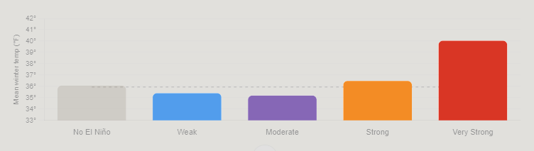
Very Strong: 4.0 degrees warmer than average
Strong: 0.5 degrees warmer than average
Moderate: 0.7 degrees colder than average
Weak: 0.5 degrees colder than average.
Mean temperature between December and February for Atlantic City International Airport and Sen. Frank S. Farley State Marina in Atlantic City, based on the intensity of the El Nino (graphic is from Claude Artificial Intelligence, via NOAA data).
The stronger the El Niño, the warmer the temperatures. That’s because the Pacific jet stream – the river of air about 30,000 feet high that separates two airmasses – pushes into the Northeast. That means more opportunities for us to be south of the jet stream, taking in milder air.
Winter snow: One clear signal
Like winter temperatures, using El Niño alone doesn’t produce a big trend in what snow could look like for a winter. Generally, it’s a little less snowy than average. However, when you look at the type of El Niño, there is a trend that screams off the chart.
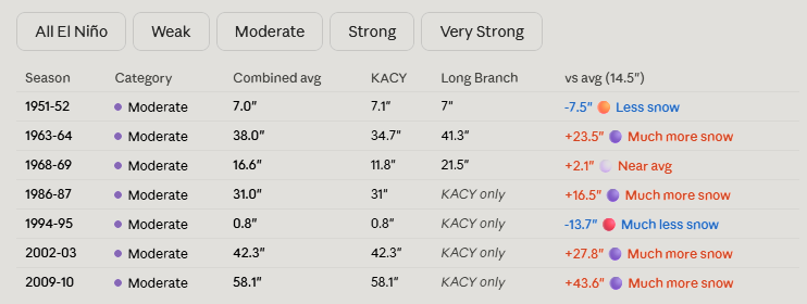
When El Niño is in a moderate phase, it’s 13 inches snowier than average. For the South Jersey shore, that’s 25 to 30 inches of snow. Farther up the coast, that’s roughly 30 to 35 inches of snow.
Here’s the snow breakdown for Atlantic City International Airport and Long Branch, by El Niño phase.
Weak: 3.5 inches below average
Moderate: 13.2 inches above average
Strong: 3.4 inches below average
Very strong: 0.2 inches above average
Winter snowfall totals for the Jersey Shore, based on the intensity of the El Nino (graphic is from Claude Artificial Intelligence, via NOAA data)
The last two moderate El Niño winters were 2009-’10 and 2002-’03. Both brought plenty of snow, and winter storms. That included:
On Feb. 5-7, 2010, over 20 inches of snow fell roughly south of the Atlantic City Expressway. Meanwhile, New York City experienced less than 4 inches of snow.
A few days later, the Feb. 9-11 winter storm brought over half a foot of snow to the shore.
The Feb, 16-18, 2003, winter storm, known as the President’s Day II or PDII storm, dropped over 18 inches of snow on much of the Jersey Shore and ranks as the sixth strongest winter storm on NOAA’s Northeast Snowfall Impact Scale.
Moderate El Niños sit in a weather sweet spot for winter storms in New Jersey. They enhance the jet stream’s pattern in a way that funnels nor’easters up the coast without warming the region enough to flip precipitation to rain.
😎TUESDAY’S FORECAST | For the first time in NINE weeks, we have a dry workweek. Some think that means a boring weather video, but not here at the Jersey Shore. There are a few exciting things to talk about!
Tired of water in your basement or crawlspace? Trust Finally Dry Waterproofing family-owned company to fix it right. We install permanent drainage solutions guaranteed for 2 ownerships with no limit! Get your FREE inspection at finallydrywaterproofing.net .
FRIDAY’S FORECAST| It’s a somber start to Sept. 11. However, like the American spirit afterwards, it will be bright after these AM showers.
🏈 Your Rutgers tailgate headquarters! Parking at St. George is only 500 yards from SHI Stadium and features 500+ spots, clean restrooms, and quick access to River Road. It’s where Joe parks! Purchase at: www.rutgersparking.com .
The 2026 summer weekend weather season at the Jersey Shore had plenty of ups and downs. It started with a major weather setback, improved through the heart of summer, and ended on a much stronger note.
Memorial Day weekend received an F, with rain, chilly temperatures and highs only in the low 60s at times. The weather slowly improved through June and July. The first A came from June 12-15, while the Fourth of July weekend earned a B despite hot, humid and stormy conditions.
The second half of summer was much better. From late July into August, most weekends earned grades in the B range or higher. Overall, the summer finished with three A’s, four B+’s, six B’s, one C+, one C and the Memorial Day F.
Labor Day weekend provided the strong finish the summer needed. Saturday and Monday earned A’s, while Friday and Sunday received B+ grades. That gave Labor Day weekend a 3.75 GPA, or an A.
After all of that, the 2026 summer finished with a 3.0 GPA, tying 2021. The best year remains 2019, which finished with a 3.4 GPA.
🥵THURSDAY’S FORECAST | Summertime heat and humidity for today! This typically only happens only once or twice after Labor Day.
Rain? Ehh. It’s mostly dry this week and through the weekend.
Why settle for big chains? Choose Just4Wheels’ family-owned locations all across NJ! Rent brand-new sedans, passenger vans, box trucks and more today! Visit www.just4wheels.com or call 877-650-3500.
The federal flood insurance fight | Tidal Flooding Talk (9/29/2026)
What happens beneath the ocean during storms? | Tidal Flooding Talk (9/22/2026)
NASA Scientist Explains the Strange Tides of Other Worlds | TFT 9/15/2026
How Flood Rules Help Protect Shore Homes | TFT 9/8/2026
The Uncomfortable Truth About Louisiana’s Disappearing Coast
For Jersey Shore homeowners, flood safety often starts long before the water rises.
On the latest episode of Tidal Flooding Talk, New Jersey zoning officer and floodplain administrator Roger McLarnon explained how local zoning, construction rules and floodplain regulations work together to reduce storm damage and prevent costly mistakes.
McLarnon, who also works in Ventnor and Somers Point, said one of the biggest problems officials encounter is homeowners doing work without the proper permits. That can become especially expensive when a project violates zoning requirements or creates problems with floodplain compliance.
“Before you build it, it’s easy to deal with,” McLarnon said during the podcast. Once work is complete, correcting the problem can be far more difficult.
A major focus of the discussion was what can — and cannot — be done below a home’s design flood elevation. McLarnon said FEMA rules generally limit those lower areas to parking, storage and entryways. Converting that space into bedrooms, bathrooms, kitchens or other living areas can create serious compliance problems and leave expensive improvements exposed to flood damage.
The episode also highlighted the value of planning for future flood risk instead of simply meeting today’s minimum standards. McLarnon said Margate and Ventnor have worked to align zoning and floodplain rules so homeowners are less likely to get caught between competing requirements.
That coordination matters because zoning approval and floodplain development approval can both be required before a construction permit is issued. Palma Shiles, who works in Margate’s construction office and co-hosts the podcast, said having those reviews work together can help property owners avoid paying to redraw plans multiple times.
McLarnon also discussed how seemingly similar neighboring properties can have very different legal circumstances. In some cases, an improvement next door may be grandfathered in. In others, it may have been completed without a permit at all.
The larger message was simple: ask questions before building.
McLarnon said his goal is not just to enforce rules, but to help property owners find a legal path forward. His interest in floodplain management comes partly from growing up in Ocean City and watching major coastal storms, flooding and waves damage homes.
He said that experience shaped how he views the job today.
The goal, he said, is to make sure that after a major storm, residents still “have a home to come back to.”
That is the heart of floodplain management: not just paperwork and permits, but reducing the chance that one storm becomes a life-changing loss.
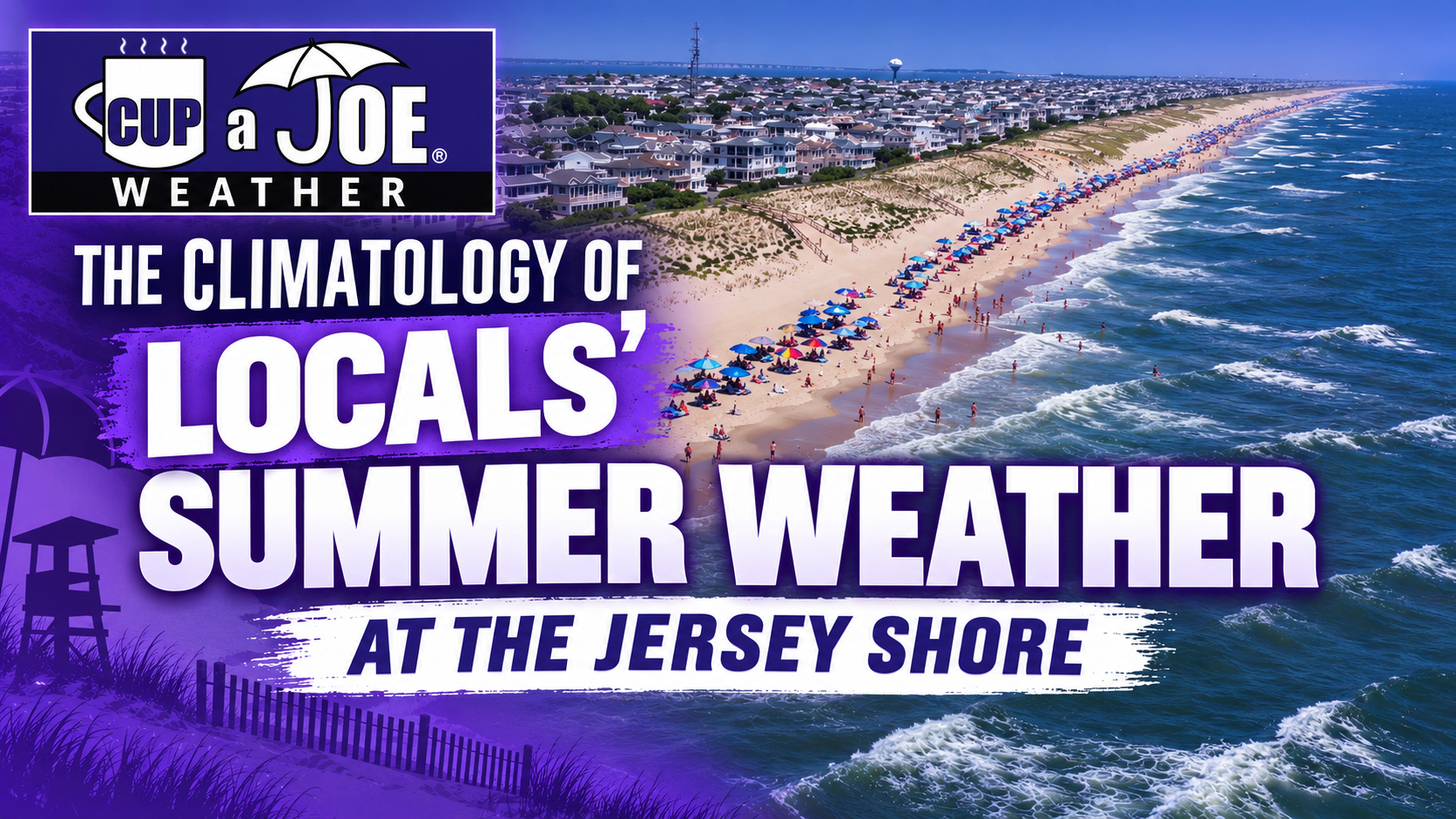
Locals’ Summer. Warm days, pleasant water and sunshine that isn’t burning.
We know it, we love it and it provides a nice extended boost to the shore economy. Now, with help from large-language models, we now know how long Locals’ Summer lasts, according to the weather data.
A review of post-Labor Day temperatures and rainfall in Atlantic City and Long Branch shows that plenty of warm days typically remain. Long Branch averages about six days reaching at least 80 degrees after the holiday, while Atlantic City averages three. Both locations average double-digit totals of days with highs of 75 degrees or warmer.
Each community holds onto summer differently. Long Branch behaves more like a mainland station because it does not have a bay or river directly to its west. That allows temperatures to climb more easily during the day. Atlantic City’s barrier-island location limits some daytime warmth as surrounding waters cool in October, but the water also helps the city remain milder at night.
History shows that locals’ summer can last well into autumn. The standout year was 1941, when 13 post-Labor Day days were both dry and at least 75 degrees. From Oct. 1 through Oct. 8, the average high was at least 81 degrees. The running average high did not fall below 75 until Oct. 24, providing roughly seven weeks of consistently warm weather.
The best odds for a dry day of at least 75 degrees continue through much of September. Around Sept. 25 or 26, the daily chance slips to 25% or lower. Even then, beach-worthy warmth remains possible.
The strongest proof comes from the latest Locals’ Summer days in the database. Depending on the location, both 2022 and 2024 delivered dry weather and temperatures in the 80s on Nov. 7.
The numbers carry an encouraging message: Summer does not suddenly disappear after Labor Day. At the Jersey Shore, warm sunshine can provide an encore lasting weeks—and sometimes months—beyond the traditional season.
☀️FRIDAY’S FORECAST | You know what they say: Memorial Day Weekend we shiver, Fourth of July we sweat (and boy did we) and Labor Day weekend we shine.
We got that shine for most of our holiday weekend!
🏈 Your Rutgers tailgate headquarters! Parking at St. George is only 500 yards from SHI Stadium and features 500+ spots, clean restrooms, and quick access to River Road. It’s where Joe parks! Purchase at: www.rutgersparking.com.