This article initally appeared in Shore Local magazine on Dec. 30, 2025
A variety of weather and near weather events grace my Jersey Shore top 10 events of 2025 list. However, there are two notable absences.
Snow did not make my list, at least not directly. The snow on Dec. 14 did peak at the Jersey Shore, but the highest totals were only in northern Ocean and Monmouth County. Feb. 11-12 was the opposite. Atlantic and Cape May counties picked up five to nine inches of snow. The northern part of the shore had less, while typically snowy Sussex County barely had a flake. There was no unifying Jersey Shore storm like the blizzard of 2022.
Also absent is yearly warmth. For the first time since 2014, the Jersey Shore will fall outside of the top 20 for hottest years since reliable records began in 1895, according to Dave Robinson, the New Jersey State Climatologist, while also my “weather dad” and May 13 birthday buddy.
However, a stretch of extremely hot days did make the top 10, so did muggy weather, severe weather, frigid weather, nor’easters, tropical systems, among other things.
Note that the data below is from the National Oceanic and Atmospheric Administration, unless written otherwise.
Let’s get into it.
10) Fortescue’s stifling high dew point on July 25
Fortescue juts out into the Delaware Bay in Cumberland County, allowing the sometimes very warm water to come onto the marshy land. Bay waters in the 80s paired with a very sultry wind from the Deep South brought the dew point to an astounding 88 degrees at 4 and 5 p.m. that day. That makes for extremely uncomfortable heat indices:
2 p.m.: 106 degrees
3 p.m.: 112 degrees
4 p.m.: 121 degrees
5 p.m.: 118 degrees
6 p.m.: 120 degrees
7 p.m.: 118 degrees
8 p.m.: 109 degrees,
9 p.m.: 97 degrees.
A heat index of 109 degrees at 8 p.m. here is rare. A 121-degree heat index maybe happens three times a year in New Jersey, and it’s only for one town.
Most places in New Jersey never experienced a dew point that high in their record. So, while this only happened in one small community, its impact is might enough to be number 10.
9) Severe heat to severe weather on July 25
Inland high temperatures were as high as 100 degrees (Toms River) with everyone else in the mid to upper 90s. Couple that with high dew points and it was sweltering in the sun.
As is often the case, though, big-time heat means big time thunderstorms.
During the evening, a cold front pushed in from the northwest. The result was a line of thunderstorms that brought many downed trees and powerlines to Ocean and Monmouth counties. Beach Haven, in Long Beach Island had a waterspout. Further north, Seaside Park registered a wind gust of 66 mph.
8) White Christmas drought continues
For the fifteenth year in a row, most of the Jersey Shore went without a White Christmas, the longest on record. Officially, a definition of a White Christmas is at least one inch or snow on the ground Christmas morning. Here were the last White Christmases, by location.
Atlantic City International Airport: 2009
Long Branch, Monmouth County: 2009
Lower Township, Cape May County: 2000
Well inland parts of the northern coastal counties did have a White Christmas in 2024 but for most of our area, it’s been a while. Sorry, Santa.
7) Impressive late winter cold
February 18-20 was the latest three-day streak of sub-freezing temperatures in decades.
At Atlantic City International Airport, Sen. Frank S. Farley State Marina in Atlantic City and Lower Township, the last time this happened this late or later in winter was in 1993.
ACY airport and Long Branch were below 30 degrees all three days. That hasn’t happened since 1980, at the very end of February and beginning of March.
6) June 21-25 Heat Wave
We just went from one of the latest cold snaps on record to one of the earliest streaks of 100-degree heat.
At Atlantic City International Airport, the temperature hit a hot 102 degrees on two days in a row, June 24 and June 25. The last time the airport had two days in a row reaching 100 degrees or higher was during the big heat wave in July 2011. These 100-degree days were the third earliest on record. When looking only at days that reached 102 degrees, they were the second earliest.
Of course, those two days broke the daily records for June 24 and 25. The airport also set a daily record on June 23 with 98 degrees.
Even the beaches felt the heat. At the Atlantic City Marina, June 23 was the first day of 90 degrees since 2022, reaching 93 degrees and breaking a daily record. Two days later, it tied another record high at 95 degrees.
During the six-day heat wave from June 21 to 26, both the airport and the marina set records for the warmest low temperatures at night.
5) October 12-13 Nor’easter
This is the first of two big tidal flooding events of the year.
Powerful onshore winds stacked the bays, bringing flooding conditions to five consecutive high tides. In the back bays, the constant onshore wind prevented the salt water from fully draining out before the next high tide.
Waretown, Ocean County, reported its highest tide on record. That being said, records only go back to 2018. Several gauges reported top 10 tidal heights since at least the year 2000. Numerous roads were closed due to tidal flooding and places that do not usually have tidal flooding did.
The most northern Jersey Shore town, Sea Bright, had 18 occupants removed from 12 flooded vehicles on Ocean Avenue, the only main road in town.
Atlantic City, Harvey Cedars, Little Egg Harbor and Seaside Heights had gusts over 50 mph on both Oct. 12 and 13. Sea Girt gusted to 51 mph on Oct. 13. Even Oct. 13 gusted over 40 mph in a few beach towns.
Six of the 81 beaches inspected by the New Jersey Department of Environmental Protection had major erosion. Another eight had moderate erosion.
4) Whipping Winter Winds
I cheated for this one, but since the strongest winds were after December 2024, I’ll count it for 2025.
The average December-March wind speed at Atlantic City International Airport and Ocean County airport was the highest since the winter of 2010-2011. Lower Township had the breeziest wind since 2017-2018.
Bad hair days and frigid faces were common all winter long. January 2025 had 16 days with gusts over 40 mph somewhere within the New Jersey Weather Network stations, run by Robinson and the state climate office. That was a record high for the network
The winter also was the most or was tied for the greatest number of wind advisory for 46-57 mph wind gusts for Atlantic and Cape May counties since we started keeping track in 2006.
A few days were extremely windy.
Feb. 16-17: ACY Airport had the second highest wintertime gust on record, since 1943. It clocked in at 71 mph. Most shore counties gusted over 45 mph. Over 200,000 thousand people were without power throughout the state.
March 5-7: Winds gusted over 50 mph in Fortescue and Woodbine, with many others in the 40s.
People have asked me for years if it’s been windier at the Jersey Shore in recent years. While it’s a hard sell after this winter, the answer is still no, it’s not gotten windier.
3) Hurricane Erin August 20-22
This is probably the most significant hurricane with virtually no meaningful rainfall in the shore’s history. Hurricane Erin’s eye always stayed at least 400 miles away. Yet, the following happened Let’s go through the stats:
The highest summertime tide on record for Atlantic City, Absecon, Sea Isle City, Stone Harbor, Cape May (bayside).
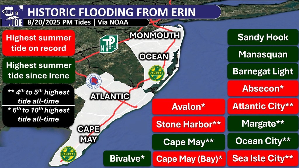
The highest summertime tide since Tropical Storm Irene in 2011 for virtually every other tidal station on the Jersey Shore.
Closed beaches on Aug. 20, 21 and 22. 50 water rescues due to tidal flooding in Margate.
Water rescues on the Black Horse Pike and White Horse Pike between Atlantic City and the mainland.
Ocean wave heights of 10 to 15 feet.
Wave periods at an extremely long 15 seconds or more.
Nine beaches had moderate beach or dune erosion.
Thankfully, no deaths from the high surf and rip currents occurred.
While many of us typically associate hurricane season in New Jersey in September and October, this was a good reminder that hurricane season runs during our busiest time of the year at the coast, the summer.
2) The April Jones Road Fire

The Jones Road Fire, which was first spotted at 9:45 a.m. on April 22, was the fourteenth largest fire in the state’s period of record. It swallowed up 23 square miles in Ocean County, or a little over 15,000 acres, according to the NJDEP.
It started on April 22, 2025, from a bonfire that two teenagers did not put out all the way. Dry weather, strong winds, and low humidity helped the fire spread quickly.
Thousands of people had to leave their homes for safety, the Garden State Parkway closed, and smoke made the air bad even in New York City.
One commercial building and some outbuildings were destroyed, but no homes were lost and no one was hurt. Firefighters worked hard and stopped the fire completely on May 12, 2025.
From Jan. 1 to April 25, 662 wildfires occurred in New Jersey.
Last year through April 25, about half as many wildfires occurred.
The difference was drought. When the Jones Road Fire began, that area was in a transitionary state between drought and no drought, known as abnormally dry conditions, according to the United States Drought Monitor.
1) Drought
The Jones Road Fire was caused, in part by the drought. The first four months of 2025 continued the significant drought that ramped up severely during the driest Fall on record in 2024.
Voluntary water restrictions were in place. New Jersey American Water urged customers to reduce water usage.
The United States Drought Monitor had at least part of the Jersey Shore in one of the four stages of drought until May 20. An ‘extreme drought,’ the second highest level of drought gripped Ocean County south to Cape May until early March.
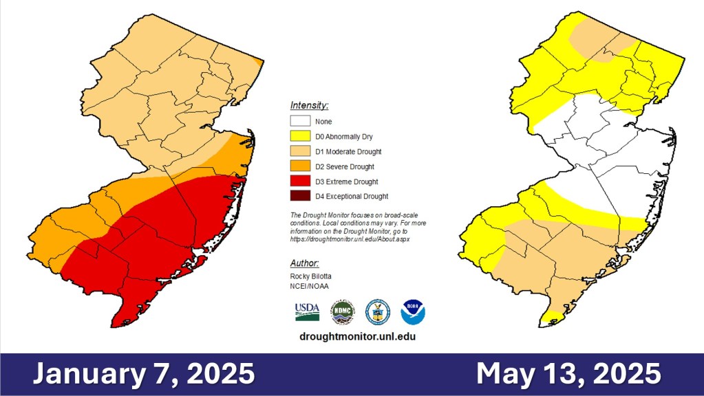
Groundwater from the Kirkwood-Cohansey aquifer in the southern half of the shore counties was ‘extremely dry” through May. Streamflows at the Jersey Shore were ‘extremely dry’ for 32 weeks in a row to start off the year.
The NJDEP continued the Drought Warning in the state on June 11. Even then, Cape May, Atlantic and most of Ocean counties were downgraded just to a Drought Watch, instead of normal conditions like the rest of the state.
The fifth wettest May on record dating back to 1895 busted the drought. However, it was only temporary.
A Drought Warning returned to the state on Dec. 5. Voluntary water restrictions are in place. Extremely dry streamflows and groundwaters returned during the Fall for most of the Jersey Shore. Most of Cape May County joins the western half of the state in drought according to the United States Drought Monitor.
More than likely, December will wind up drier than average across the coastal counties. That puts a lot of pressure on January and February to have more precipitation than average.
If not, more fires like the Jones Road one threatens going into Spring.
Finally…
Dave Robinson, the state climatologist, and I will compare our top weather events of the year during our Monthly Weather Roundup. Look for that on the Cup A Joe Weather and Drone website as well as social media channels on Dec. 30.
He put the October nor’easter above Hurricane Erin, but our number one and two events are the same. What do you think of the list? Leave me a note.
Have a fun, safe New Year. Looking forward to sharing more with you on Shore Local in 2026.
Leave a Reply