
A strong El Niño will shape New Jersey’s winter, but that doesn’t give us a simple answer about snow.
I spoke with Dr. John Krasting, New Jersey State Climatologist, about what this Pacific Ocean weather pattern could mean for the Jersey Shore.
El Niño happens when water in the tropical Pacific stays warmer than usual. That warmth can change the jet stream, the fast-moving air that helps steer storms.
During El Niño winters, a stronger southern jet stream can bring more rain and coastal storms toward New Jersey. However, every El Niño is different. Some winters have been warm and fairly dry, with one major snowstorm standing out.
My research on very strong El Niño events points toward milder winters at the Jersey Shore. That could favor rain over snow during many storms.
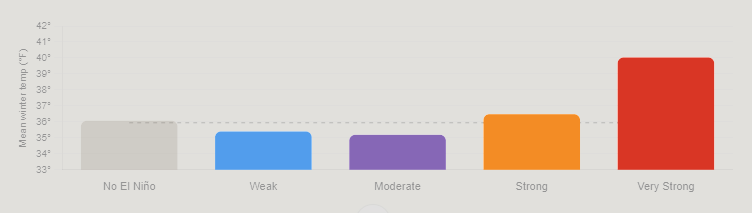
Still, a mild winter can deliver a big snowfall. We would need cold air and the right storm track to come together.
High pressure to our north could also slow storms down. That makes coastal flooding another concern to watch as winter approaches.


