
New Jersey’s weather from Thanksgiving to near Christmas could have a wildcard this year, and it starts miles above the North Pole.
In the video, I explain the likely earliest disruption of the polar vortex. This sudden stratospheric warming event would shape our weather during the holidays. But before you picture snow covering the Parkway, there are a few pieces to understand.
The stratospheric polar vortex is a ring of strong winds surrounding bitterly cold Arctic air, roughly 10 to 30 miles above Earth. It sits well above the jet stream that helps steer our daily weather. The two can influence each other, but they are separate features.
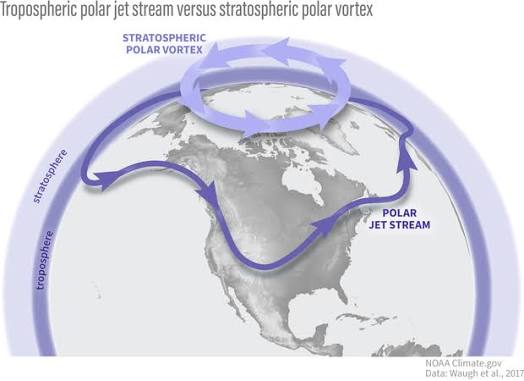
Sometimes, waves of energy from the atmosphere below disturb that ring. The winds weaken as the polar stratosphere warms quickly. During a major sudden stratospheric warming (SSW), those winds reverse direction. Changes in the weather closer to the ground can follow over the next several weeks, though the results vary.
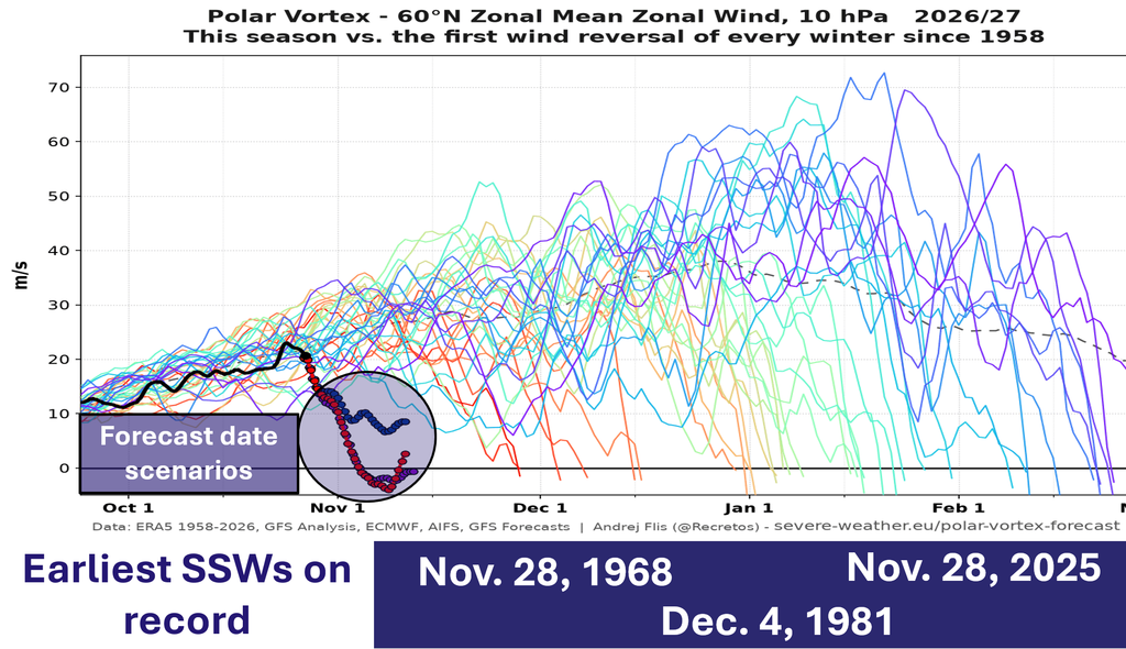
This is forecast to happen between Halloween and Nov. 10. It doesn’t matter when. This would be the earliest SSW on record, and it’s not particularly close.
For New Jersey, that raises questions about cold air and future storm tracks. It does not give us a snowstorm date. A disruption high above the Arctic does not automatically send its effects straight to our state.
Meanwhile, El Niño is part of the picture. NOAA’s October 8 update confirmed a strengthening El Niño and favored strong to very strong conditions lasting into early 2027. That is a seasonal influence, not a promise about any single storm.
For snow lovers from Sussex County to Cape May, the key is whether moisture arrives while the air is cold enough. Temperatures through the atmosphere matter: a warm layer can melt falling snow before it reaches your driveway.
Along the Jersey Shore, keep tidal flooding in the conversation. Persistent onshore winds, waves and high tides can flood coastal communities even without snow. A dry backyard does not always mean a dry road near the bay.
I’m watching whether the disruption develops, whether its influence reaches the lower atmosphere, and where cold air settles.
WeatherFront is your one-stop shop for weather data. Experience the game-changing user interface on iOS, Android, or web today at www.weatherfront.com
Know More: Watch the coupling, then the storm track
The key diagnostic for a major sudden stratospheric warming is the daily mean zonal wind at 60°N and 10 hPa reversing from westerly to easterly. NOAA’s SSW compendium applies that criterion during November through March. A stretched or split vortex on a map, by itself, does not establish a major warming.
Next comes downward coupling. Does the stratospheric disturbance influence circulation in the troposphere? NOAA notes that a disrupted vortex can be followed by a wavier jet stream, but the surface response varies. The stratospheric vortex itself does not descend onto New Jersey.
For NJ forecasting, my next checks are Atlantic blocking, the Pacific pattern, cold-air placement and individual storm tracks. Even with a favorable large-scale setup, precipitation type still depends on the temperature profile. Shore impacts also require a separate look at onshore wind duration and tide timing.
Treat Thanksgiving into December as a window to monitor, rather than a verified period of major storms.


